Map showing zones of "geoglyph" fossilised agricultural systems.
 Hillforts in Bolivia compared to hillforts in Peru and England
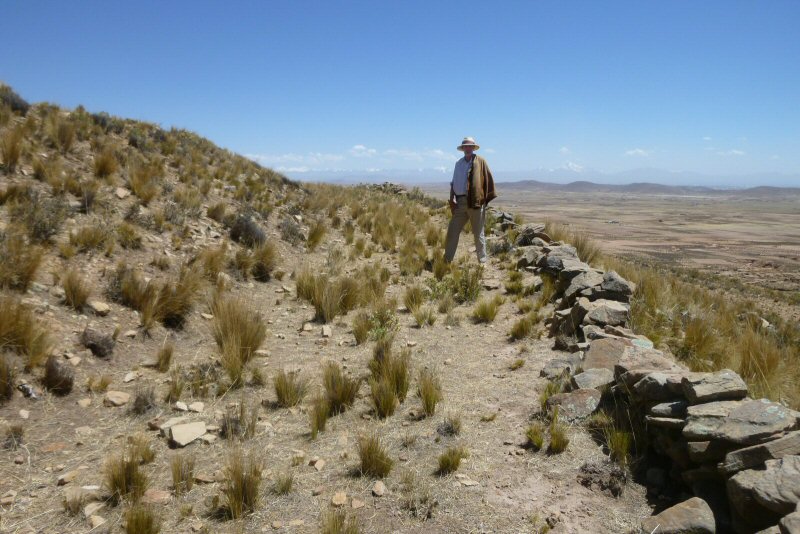
Satellite imagery of areas of the Bolivian Altiplano north east and south east of Tiwanaku shows an extensive system of fossilised agriculture destroyed by earthquakes. These formations are often accompanied by hilltops surrounded by concentric rings which appear to be remains of concentric irrigation canals. In some cases, the hilltops may have been used as defensive fortifications and this page shows examples of three formations similar to hilltop fortresses such as also seen at Chankillo in Peru, also Shropshire and Dorset, in England.
Map showing zones of "geoglyph" fossilised agricultural systems.

Above, this hillfort at
Chankillo
in Peru dating to 300 BC has a very distinctive ovaloid form
and a length of about 990ft which is 900 Sumerian feet or 600 Sumerian cubits... or 360 Sumerian yards of 33.0"

Above, the hillfort at Chankillo in Peru has a breadth of approximately 770ft which is
700 Sumerian feet.

Above, this inner compound at the Chankillo hillfort
has a diameter of about 165ft which is 100 Sumerian cubits of 19.8".
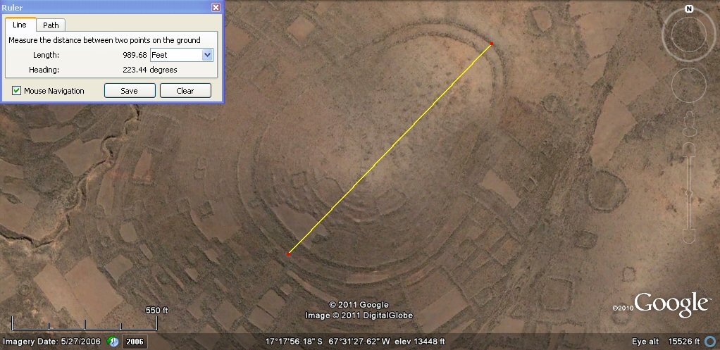
Above, this hillfort near SicaSica on the Bolivian
altiplano has the same distinctive shape as the Chankillo hillfort and an identical length of
about 990ft which is 900 Sumerian feet or 600 Sumerian cubits... or 360 Sumerian yards.

Above, the hillfort at SicaSica has a breadth of approximately 770ft which is
700 Sumerian feet, about the same as the site in Chankillo, Peru.


Above, left, site at Chankillo, Peru. Right, site at SicaSica, Bolivia.

Above, left, site at Chankillo, Peru. Right, site at SicaSica, Bolivia when rotated in paintshop to similar alignment.
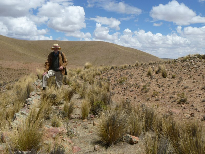
Above, remains of outer wall at SicaSica, Bolivia.
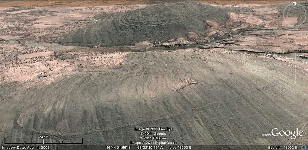
Above, 105 d and e oblique view showing remains of
concentric rings near Viacha, Bolivian Altiplano. -
At first it is difficut to tell whether the rings are remains of concentric irrigation channels or defensive works such as hill forts.
The ring in the foreground could have been irrigation canal or part of hillfort, but the concentric rings in the background site
are more similar to those of a hill fort.
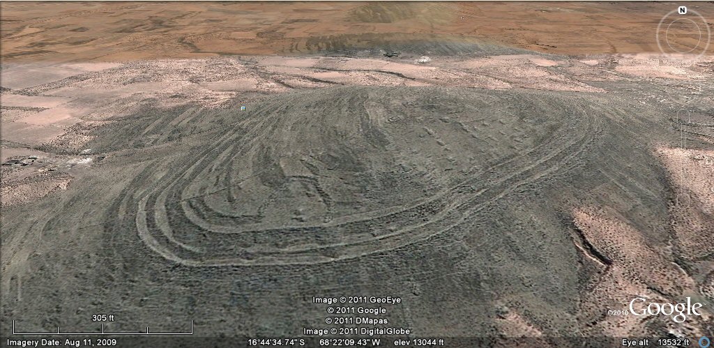
Above, 105e this set of concentric rings looks like it would have had a good capacity for
retaining water but the site has all the characteristics of a hillfort!
Above, the rings in the photo were two concentric terraces/pathways faced with walls on the outside.
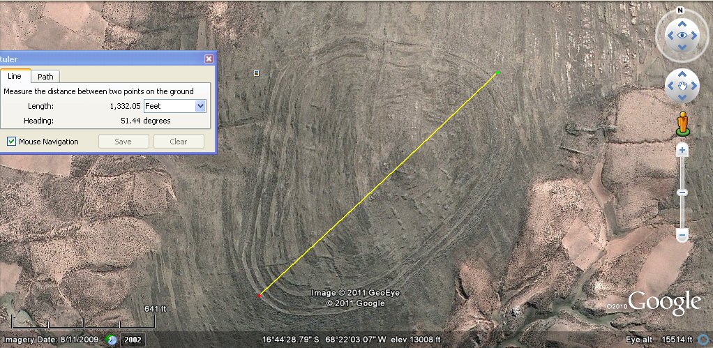
Above, 105e the overall length of the site is about 1332ft which is 1200 Sumerian feet
or 800 Sumerian cubits
or 480 Sumerian yards.

Above, 105e the overall width is about 990ft which is 900 Sumerian feet or 600 Sumerian cubits or 360 Sumerian yards of 33.0".

Above, left, site at Chankillo, Peru. Site at SicaSica,
site at Viacha, Bolivia
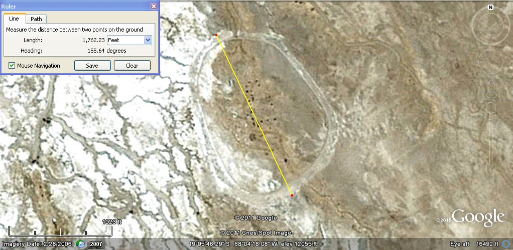
Above, this site near the village of Chipaya can hardly be called a "hillfort" since it is in the middle of the vast
Salar de Coipasa, yet it has similar characteristics to the "hillforts" of Chankillo and SicaSica, with
the same ovaloid shape but is even larger being around
1760ft long which is 1600 Sumerian feet.

Above, the inner length of the site is about
1540ft long. which is 1400 Sumerian feet or double the breadth of the sites at SicaSica and Chankillo.

Above, the width of the Chipaya site is about 1320ft
which is 1200 Sumerian feet or 800 sumerian cubits or 480 Sumerian yards....
the same as the length of the site at Viacha.

Above, oblique view of the site at Chipaya looking south towards the Salar de Coipasa.
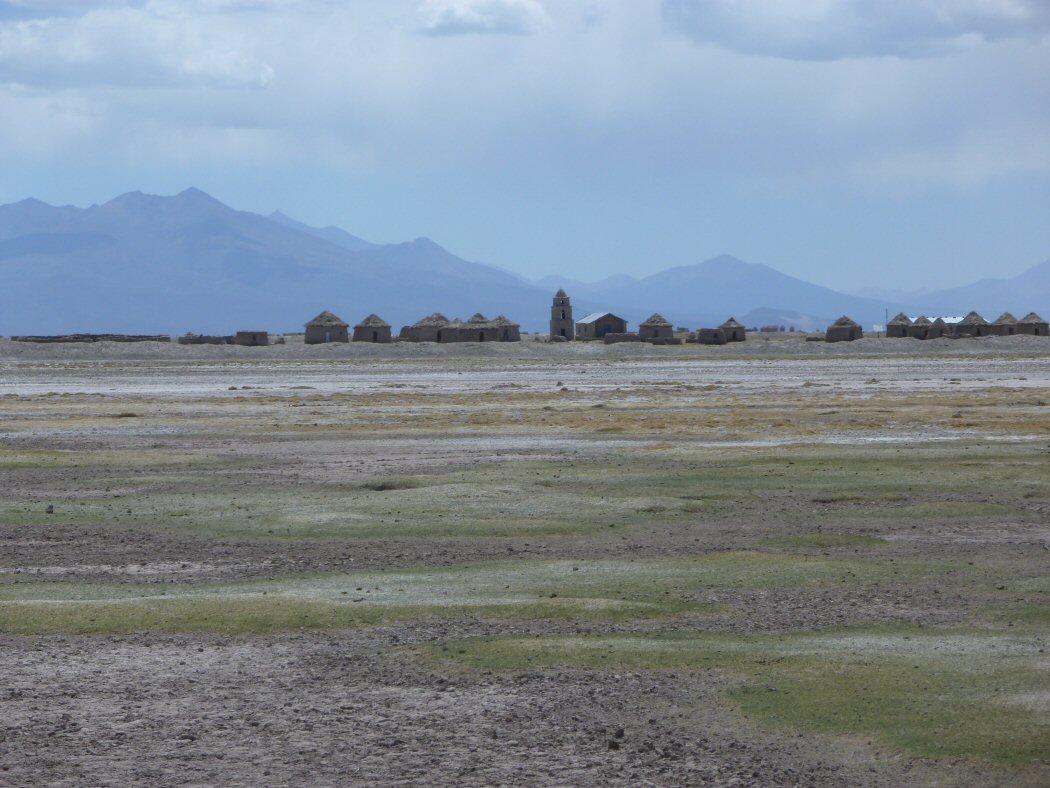
Above, ground view of the site at Chipaya. It is occupied by a modern village who apparantly engaged contractors to build the ring wall around it, it is not known whether they followed an older route...

Above, left, site at Chankillo, Peru. Right, site at Chipaya, Bolivia when rotated
and mirrored in paintshop
gives a more direct comparison with the site at Chankillo in Peru, showing the same geometry in layout.

These sites such as Chankillo although sometimes described as hillforts,
are also sometimes thought perhaps to have been observatories.
The ovaloid shape is also reminiscent of the
flattened circles and egg shapes found by prof A. Thom in "Megalithic sites in Britain". Prof Thom also put forward the use of the "megalithic yard" of 32.64" as the standard
unit used in the construction of the stone circles and many were thought to have been designed using whole numbers and Pythagorean 3,4,5 triangles.
We can note that the Chipaya formation when converted into Sumerian feet has an overall length of 1600 Sumerian feet
for the outer ring and an overall width of 1200 Sumerian feet, which if contained in a rectangular box would have a diagonal by Pythagoras of 2,000
Sumerian feet with the rectangle also aligned to the solstices. In Sumerian yards of 33.0" the figures would be 480, 640 and 800 for
the diagonal but the resolution of the imagery does not allow us to tell whether in fact Sumerian yards of 33.0"
or megalithic yards of 32.64"
were used, although Sumerian units are consistent with other sites
found throughout the country.

Above, illustration showing how the site could be enclosed in a rectangle of 1600 x 1200 Sumerian cubits,
aligned to the solstices and composed of 3,4.5 triangles. It is noticeable the width of the
inner ovaloid ring is 1,000 Sumerian feet along the central axis of
the solstice which would also be 400 Sumerian yards of 33.0" or 200 double
yards of 100 Sumerian shusi - twice the length of the platform at
Puma Punku in Tiwanaku.


Above, illustration showing how
egg shaped megalitic rings
were created and right, stone ring at
Kerry Pole, Wales

Above, left, site at Chankillo, Peru. Site at Sicasica,
site at Chipaya, site at Viacha, Bolivia

Above, the little known megalithic ring at
Wandlebury
near Cambridge, England, also described
as an iron age hillfort measures about
1054ft overall
and is said to date to around 500BC. A large country house was at one time built within the grounds.

Above, the megalithic ring at
Avebury in Wiltshire, England
is so large that a village has been built within its banks.
With an overall width of about 1374ft, it is said to be
the largest henge type stone circle in Europe and to date to around 600BC. It is about the same size as the site at Chipaya, in Bolivia although circular instead of oval.

Above, this little known megalithic ring at Viacha in Bolivia has a diameter of around 3000ft,
about three times larger than that at Avebury. Little is known about it. The inner ring has a diameter of
about 1857ft. Within
that there is a volcanic mound about 915ft in diameter in the centre
which supports two apparantly man-made circular platforms carved from the natural rock,
the central one about 117ft in diameter and the other about 110ft in diameter. The centremost cone or "pyramid"
is said to have been covered at one time with stones, but these were removed and broken up as ballast
for the nearby railway (same as happened with many of the ancient stones from Tiwanaku).
The fortification walls seen on the west side were built at a later period and were used during the
Battle of Ingavi when Bolivia
was engaged in a war with Peru.

Above, this iron age hillfort at Caer Caradoc in Shropshire, England has a length of about 1100ft or 1,000
Sumerian feet.

Above, it has a breadth of about 660ft or 600 Sumerian feet which is 400
Sumerian cubits or 1 x furlong. The use of "Sumerian" cubits seems to have been a
universal system both in ancient Sumeria, Europe and ancient America whilst the ditches
and general size is similar in style to the site at Viacha in Bolivia

Above, this iron age hillfort at
Maiden Castle in Dorset, England has a length of about 3300ft or 3,000
Sumerian feet or 2,000 Sumerian cubits or 5 furlongs which is
also 10 "Atlantis stades"
of 330ft (200cubits) or 20
"Atlantis stades"
of 165ft (100 cubits) making it three times the size of the hillfort at Caer Caradoc and said to be the largest hillfort in Britain and Europe
The hillfort is said to date to 450BC and built on the site of a neolithic enclosure dating to 4,000BC. The length of 3300ft equates to 3,000 feet of 13.2 inches which is sometimes called a "Saxon" foot but is actually a "Sumerian" foot of 20 Sumerian "shusi" and we should note that if constructed in 450BC or earlier, then it was before the Saxons invaded and conquered England. The English furlong of 660ft is similarly in fact 600 Sumerian feet or 400 Sumerian cubits of 30 Sumerian "shusi". The length of the site comes out at a nice round number of 10 half-furlongs of 330ft which can also be considered as "Atlantis stades" since these stades of 330ft or 200 cubits also were used by Plato to descibe the rectangular plain in the Altiplano of Bolivia, whilst the quarter furlong of 165ft which is 100 Sumerian cubits was also used to describe the site of concentric rings at Pampa Aullagas on the Altiplano and this quarter furlong stade is the origin of several other units of measurement since 100 Sumerian cubits of 19.8" is also equal to 96 Egyptian Royal Cubits of 20.625" - useful for dividing parcels of land so that strips of land when subdivided come out in round numbers of cubits.
It is noticable also that describing the site as 20 "stades" of 100 cubits uses the number 20 so highly favoured by meso-American and early Tiwanku cultures and the discovery of "Sumerian" units of measurement throughout the ancient Americas suggests a world wide universal culture.
See also additional studies,
fossilised agriculture destroyed by earthquakes.
agricultural variations on the Altiplano
geoforms
ringed hilltops
earthquakes
contour forms/irrigation Peru
contourforms/irigation Bolivia
Bombo earthquake route
Bombo route oblique views
atlantis canals on the Altiplano
canals gallery
Chipaya canals gallery
canals in Peru
Caral, Peru containment canal
Paria, Oruro containment canals
canal to sea (lago UruUru)
Pantanal
Beni, Moxos gallery
rio Paraguay levees canals
rio Parana canals, ponds and islands
rio Parana delta canals
Corrientes
rio Amazon to Manaus
rio Amazon west from Manaus
rio Orinocco to Amazon canal
canals on the Louisiana seaboard
Tabasco, Mexico canals gallery
flooding dates on the Altiplano
Atlantis stones gallery
Atlantis stade - Egyptian and Sumerian cubits
Tiwanaku cubits
Peru cubits and calendar
cubits between altiplano canals
Teotihuacan measuring unit
Teotihuacan citadel measuring units
Chichen Itza and El Castillo measuring units
Monte Alban, measuring units
the Tiwanaku soli-lunar calendar
the Muisca calendar
Lost Calendar of the Andes
Decoding the quipu mathematics
J.M. Allen 1st Sept 2011
webatlantis@hotmail.com