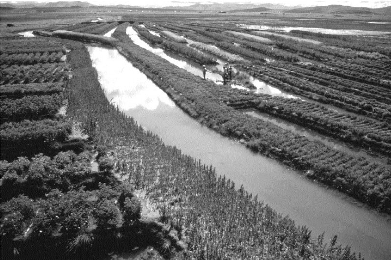
Above, an example of the "suka kollus" on the Bolivian Altiplano, raised fields surrounded by water channels.
In the Bolivian Altiplano, there exists many remains of ancient canalised fields called suka kollus or waru waru or camelones with artificially created water channels between them.
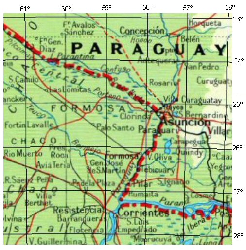
Long embankments separated by water channels can also be seen in the delta of the river Parana although it is not clear whether these are natural, or adapted and used by man.
This page looks at similar channels along the banks of the rio Paraguay which appear to be man-made or enhanced by man to utilise the natural channel-like formations and islands thus formed as a habitat.
Above, an example of the "suka kollus" on the Bolivian Altiplano, raised fields surrounded by water channels.
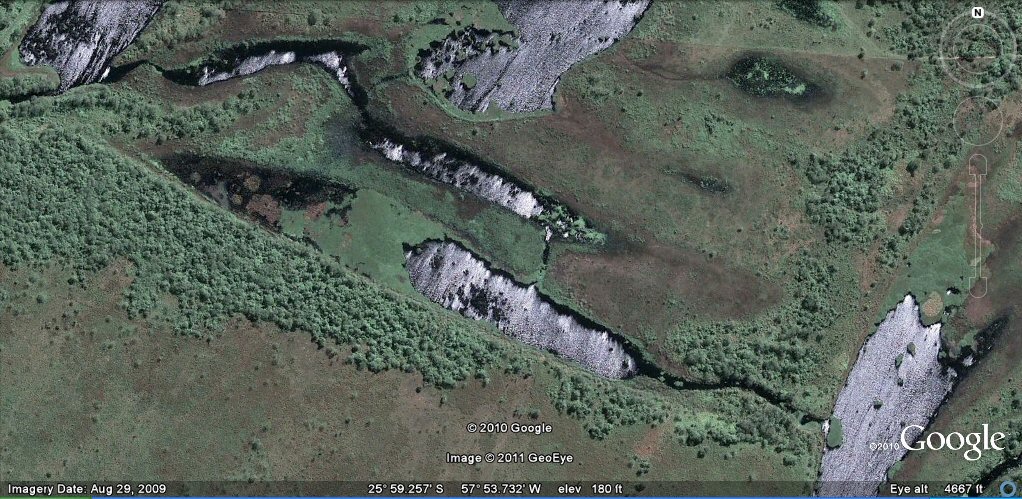
Above, a typical example of natural channels and landforms deposited by the rio
Paraguay. The natural channels and long narrow islands appear to be crossed by clearly defined
channels which look as though they could have been man-made canals for the purpose of interconnecting
the natural channels and providing water to channels which might have been cut off due to the accumulated
river deposits.
The is what Wikipedia has to say about levees...
"Levees are commonly thought of as man-made, but they can also be natural. The ability of a river to carry sediments varies very strongly with its speed. When a river floods over its banks, the water spreads out, slows down, and deposits its load of sediment. Over time, the river's banks are built up above the level of the rest of the floodplain. The resulting ridges are called natural levees.
When the river is not in flood state it may deposit material within its channel, raising its level. The combination
can raise not just the surface, but even the bottom of the river above the surrounding country. Natural levees
are especially noted on the Yellow River in China near the sea where oceangoing ships appear to sail high above
the plain on the elevated river. Natural levees are a common feature of all meandering rivers in the world."
However, we should also take note that
according to another article,
"A natural levee is a narrow ridge
of alluvium deposited at the side of the channel. During high discharge periods when the stream floods,
coarse sediment settles out near the stream channel and grades to finer material further away. The over
bank deposits of alluvium are often rich sources of nutrients for soils developed on the floodplain.
Because floodplain soils are usually quite fertile, humans have inhabited them for years. To prevent
flooding, artificial levees are built close to the channel, typically higher than natural levees.
Confining the flood discharge to a small area increases the velocity of flow.
Many of the levees along the length of the river show signs of artificial channels constructed
as above, there are far too many examples to publish on this single page but the channels are typically of
about the same size, either 110ft (100 Sumerian feet) or
165ft (100 Sumerian cubits)
More on levees...
The Flanary Archaeological Site is ideally suited for prehistoric habitation. The natural levee floods frequently today, but was probably high and dry when Native Americans inhabited the spot. Here, the Clinch River turns shallow and broad, allowing for safe and easy access to the other side of the water as well as a perfect opportunity to harvest mussels, fish, turtles, and aquatic birds. The nearby hills supplied unlimited supplies of firewood, fibers, nuts, and berries, as well as large populations of deer and other game. Many spots nearby also offered high quality clay that could be used to make pottery, as well as rocks to be turned into tools.
Evidence suggests that Native American groups camped on and inhabited the spot intermittently for the last 8,000 years. A more permanent palisaded village was erected during the Woodland Mississippian period, around 900 AD. Evidence of a palisade, circular house, and ceramics have been found on the spot, along with an intact skeleton, but the extent of the settlement is unknown since only a small portion of the site was excavated.
No one knows when or why the palisaded village was abandoned. It may have been occupied as late as 1600 AD,
but when Dr. Thomas Walker explored the area in 1750, he reported no Indian occupants in what are now Scott
and Lee Counties."

rio Paraguay flows into the rio Parana

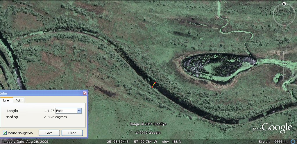
Above, returning to the earlier photo, a fine channel (at one time) drew in water from the rio Paraguay at the northern side, traverses the site and exits on the southern side.

Above, the fine channel cuts across the natural levees, traversing the site and exits on the
southern side.
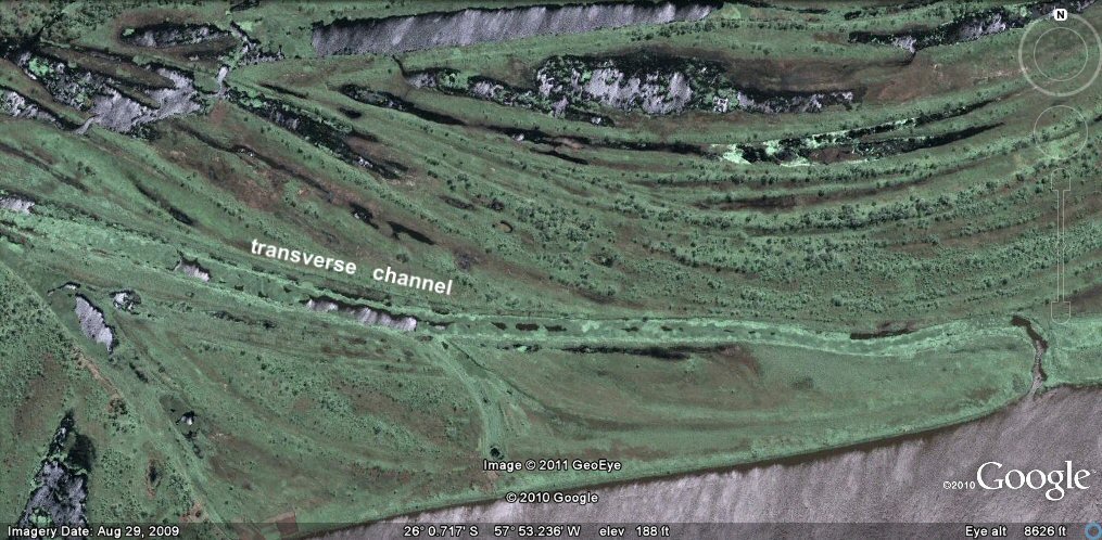
Above, this continuation of the channel is wider, traverses the site and exits on
the southern side, but a new entrance has been cut in, seen in the lower right hand corner of the above photo.

Above, an entrance has been cut into the channel from the river Paraguay half way along its length.
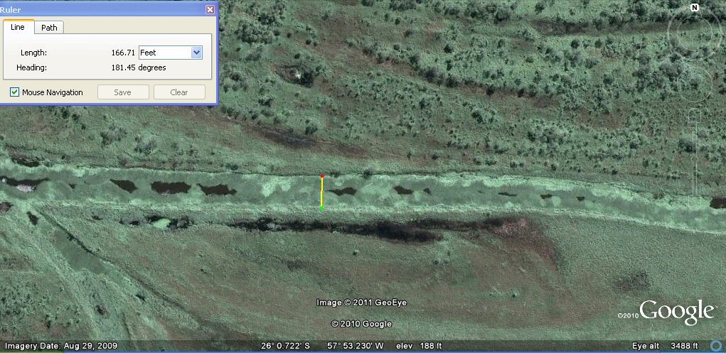
Above, the channel has a width of about 165ft or 100 sumerian cubits.
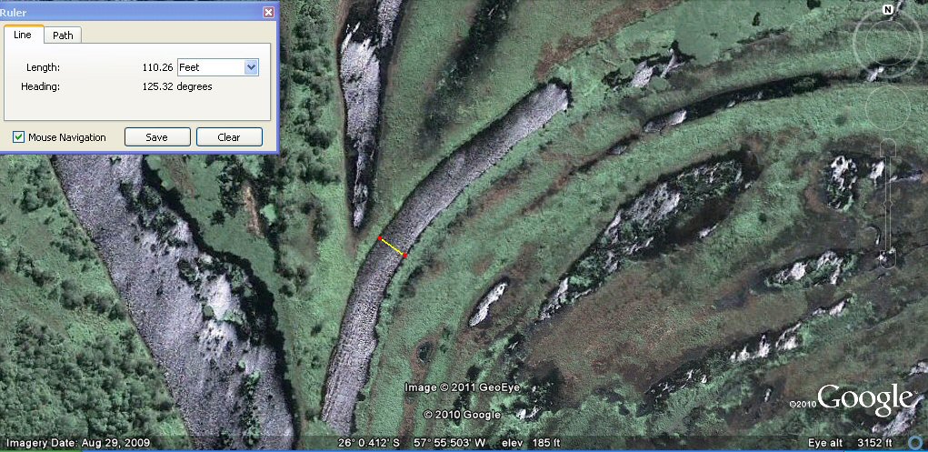
Above, the exit of the transverse channel has a width of about 110ft or 100 Sumerian feet.
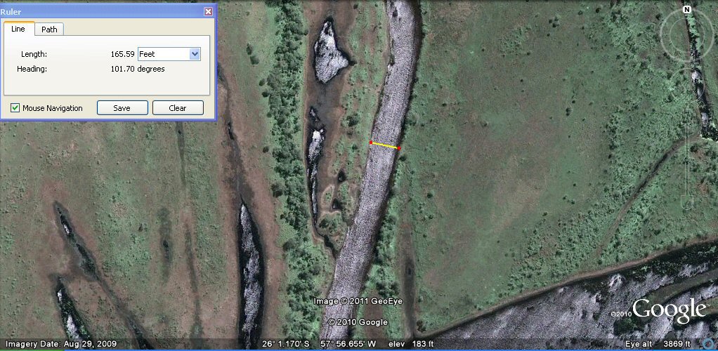
Above, another section of channel has a width of about 165ft or 100 Sumerian cubits.
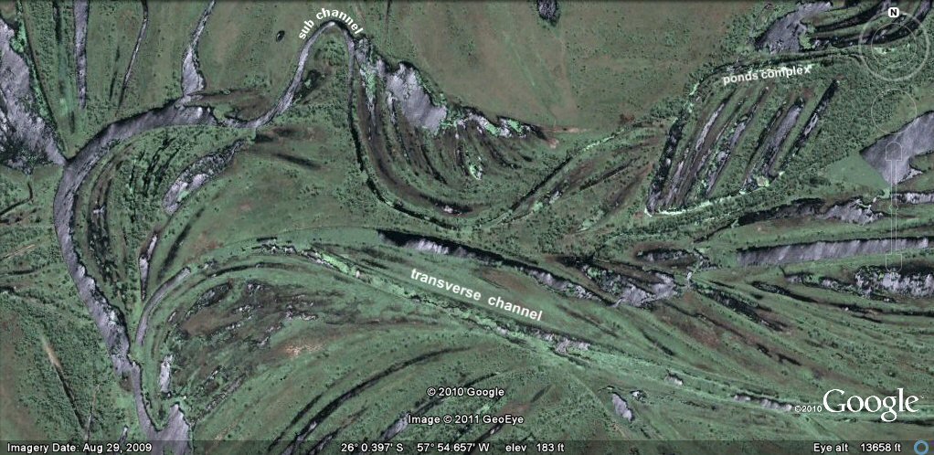
Above, view of central complex with the transverse channel and above that,
another section of sub channel looping up and around to feed complex of artificial ponds adapted from the
original natural levees...

Above, system of artificial ponds feed by entry canal from left...
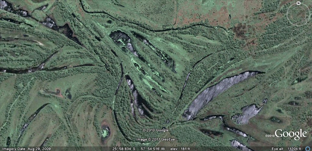
Above, another section of artificial ponds surrounded by feeder canals on the same site...
Above, close up shows how ponds are interlinked by small canals...
Above, typical channel section of about 110ft (100 Sumerian feet) in width.

Above, typical channel section of about 110ft (100 Sumerian feet) in width.
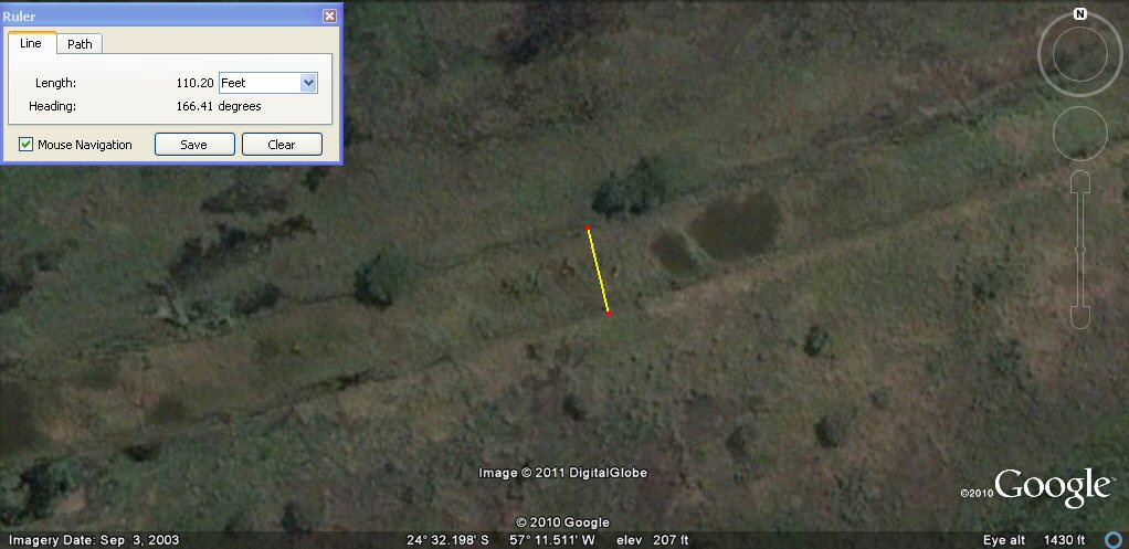
Above, typical channel section of about 110ft (100 Sumerian feet) in width.

Above, this pond measures about 2000 Sumerian feet of 13.2" which is 400 Sumerian double yards.

Above, it has a width of about 250 Sumerian double yards

Above, typical channel section of about 165ft (100 Sumerian cubits) in width.
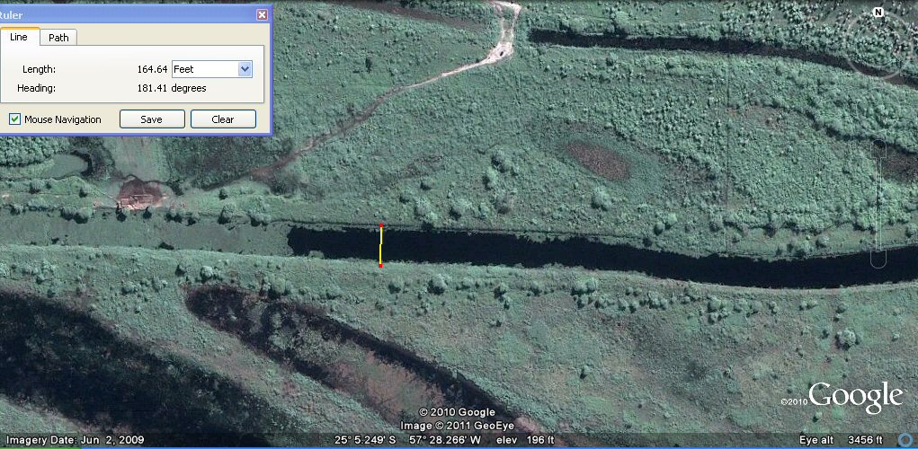
Above, typical channel section of about 165ft (100 Sumerian cubits) in width.

Native American Settlement
"A sandy terrace across the Clinch River from Dungannon
was home to Native Americans 8,000 years ago. In 1977, an archaeological dig unearthed signs of a palisaded village
that disappeared for unknown reasons around 1600 AD.
See also
canals in the rio Parana
See also
ponds in the Beni region
See also
canals in the Oruro region
See also
canals in the Oruro region
See also "geoglyph" and other agricultural formations
in the
Oruro and Tiwanaku/La Paz regions
See also
Atlantis stade, Sumerian measurements etc
Footnote
J.M. Allen, January 2011
Although refered to as "Sumerian" measurements,
they are found throughout the Americas and may have originated
in the Americas.
Briefly,
1 shusi = 0.66" (16.764mm) [16]
1 link = 7.92" = 12 shusi (201.168mm)
1 foot = 13.2" = 20 shusi (335.28mm)
1 cubit = 19.8" = 30 shusi (502.92mm)
1 yard =33" = 50 shusi (838.2mm)
1 double yard = 66" = 100 shusi (1676.4mm)
1 pole = 16.5 English ft = 15 Sumerian feet (5.03 metres)
1 chain = 66 English ft = 60 Sumerian feet (20.11 metres)
165 English ft = 150 Sumerian feet = 100 cubits
330 English ft =300 Sumerian feet = 200 cubits
660 English feet = 600 Sumerian feet = 400 cubits = 1 furlong (201.16 metres)
1 acre = 43560 sq English ft = 36,000 sq sumerian feet.
Sumerian cubit = 24/25ths of Egyptian cubit
webatlantis@hotmail.com
