the Altiplano has been successively submerged by inland seas
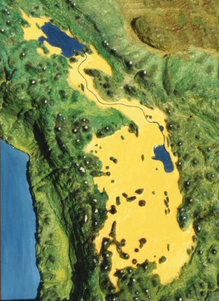
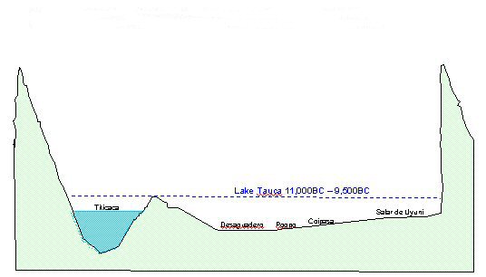
Lake Titicaca oveflows and paleolakes
the Altiplano has been successively submerged by inland seas
The site of Atlantis at
Pampa Aullagas on the Bolivian Altiplano with its outer ring of land and inner
rings of water is presently a considerable number of feet above the surrounding
land level and also the lake level of nearby Lake Poopo.
This may be partly due to the surrounding plain having dropped in elevation, and also to the nearby Lake Poopo having dropped in water level.
In order for the circular
rings of water to function as harbours with access to the lake, the lake must
have been considerably higher and a higher level would also be necessary to feed
the perimeter canal and irrigation system which was said to have run around the
adjacent level rectangular plain.
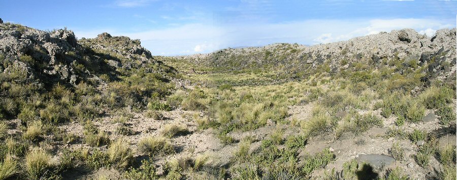
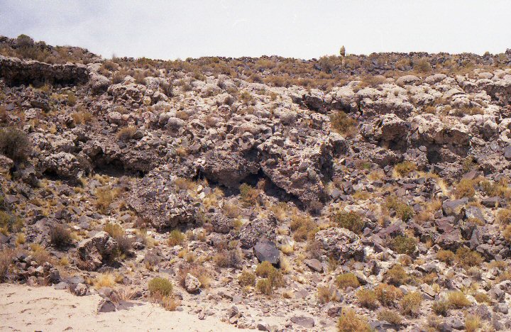
view of the outer ring at Pampa Aullagas,
the upper part is covered in volcanic boulders originally created by flowing lava while the bare sand on the slopes
beneath the boulders
suggests the plain has dropped in elevation away from the original volcanic mountain.
view of the outer ring at Pampa Aullagas,
how it may have looked before the surrounding plain dropped in elevation.
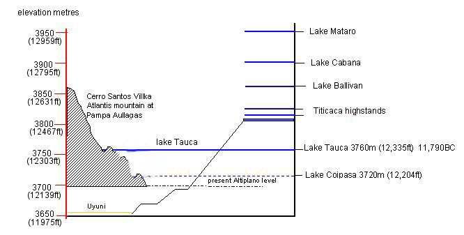
The Salar de Uyuni located on the Bolivian Altiplano at an elevation of 3653m (11,985ft) above sea level, is the world’s largest salt flat. The salar and its companion, the Salar de Coipasa were formerly occupied by a series of large lakes. The youngest was a shallow paleolake “Coipasa”, radiocarbon-dated between 11400BC and 9500BC. (10,500 to 9,900 BC according to Blard, 2012). The youngest deep paleolake “Tauca” existed 16000BC to 11790BC. (16,000 to 12,500 BC according to Blard 2012). Older paleolake “Minchin” dated from 30,000 to 23,700BC in different phases.
An analysis of core samples
taken from the centre of the Salar de Uyuni shows that there are several layers
of salt and layers of lacustrine mud, showing that the plain was successively
covered by lakes alternating with dry spells.
These lakes were fed by
water flowing south via the Desaguadero River from Lake Titicaca in the north
and in these periods the precipitation was much greater than today. Atlantis is
presumed to have existed in one of the “wet” periods when its canals were fed by
the overflowing waters of Lake Titicaca.
The two most probable dates
for the end of Atlantis according to Plato are (a) 9,600BC which is Plato's date "9,000 years before Solon" or (b)
1200BC if we substitute “months” for “years”.
Going back in time, we can
say with certainty that Atlantis could not have existed in the period of the earliest paleolakes such as lake Ballivan
3860m (12,664ft) because that would not only submerge the level plain, but also the circular rings of land and most of the Atlantis mountain itself!
From 30,000 –
23,700BC the Altiplano was covered by Lake Minchin which also appears in some reports to have been a deep lake, though
other reports have identified distinct, shallower phases.
During the next wet spell from 23,000 – 13,000BC and particularly from 16,000 – 13,000BC or later, the Altiplano was covered by the paleolake Tauca.
From 11,000 – 9,500BC Lake
Titicaca overflowed again and during this period the central Altiplano was
covered by a shallow paleolake “Coipasa”, (10,500 to 9,900BC according to Blard 2012).
At first glance it appears unlikely that Atlantis would
have existed at the time of these paleolakes since if the southern part of the Altiplano had the same elevation it has today,
the waters of lake Tauca would have been sufficiently deep
to have drowned the various canals. But that does not take into account the fact that the southern part of the
Altiplano may have sunk in elevation so estimates of the depths of the paleolakes based on modern mapping
may not reflect the actual depths based on the land elevations at the time of the lakes, also the outer canals
surrounding the mountain may have dropped in elevation when the surrounding alluvial plain also dropped in elevation due to the earthquakes.
Studies suggest that Lake Tauca had two noticeable levels,
(a) 3760m (12,335ft) around 11,790BC and (b) 3720m (12,204ft) the latter phase perhaps corresponding to that
which elsewhere has been described as lake Coipasa.
Plato mentioned that the rings of the land levels were raised a sufficient height above the level
of the sea, so on the one hand, too high a lake level would drown the rings of land and too low a level
would not allow the circular channels to function as harbours.
Although the contour map does not show the circular channels which actually exist on site, it is clear that the
level of Lake Tauca at 3760m (12,335ft) or Lake Coipasa at 3720 m (12,204ft)
would have been appropriate to enter the volcano filling the circular channels
(depending on configuration of the volcano at the time)
and creating
rings of water and rings of land and that the date is roughly in the timescale described by Plato, that is, once the paleolakes dried up leaving residual water in the channels and surrounded by the level plain thus fulfilling Plato's
description of how the "god of the sea carved the rings out of the centre of the island, making it impassible to man since ships and sailing had not yet been invented!"

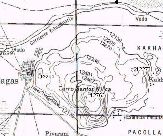
contour map of site at Pampa Aullagas with 20 metre intervals (left) and in feet (right)
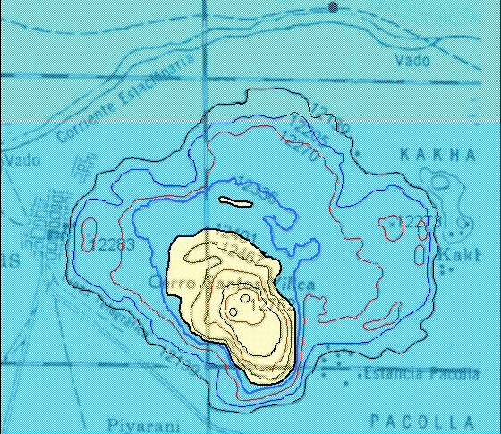

left, a highstand of 3780 metres (12,401 feet) or 3760 m (12,335 ft) for the earlier paleolake Minchin would probably submerge all the outer and middle rings at Pampa Aullagas
right, at 3760 metres (12,335 feet), paleolake Tauca would extend to
the middle channel on the western side,
but submerging the outer rings of land at their present-day elevations, suggesting
that they may also have at one time been at a higher level before sinking by earthquakes.

left, the level of paleolake Coipasa at 3720 metres (12,204 feet) would penetrate to the outer ring of the volcano according to the contour map.
right, the highest lake level today would be insufficient to penetrate to the outer channel.
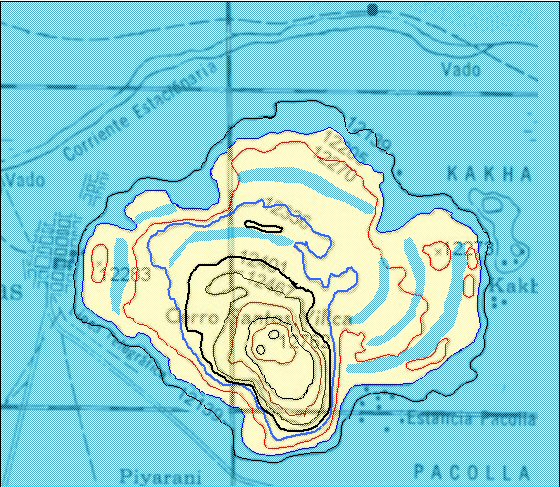
graphic showing how level of lake Tauca was correct to
enter volcano
creating rings of land and sea assuming all rings to have originally been at the same level.
Alternative scenario showing how the waters of paleolake Coipasa may
have been the right level
to enter the outer rings of the volcano according to today's elevations.

air photo of site at Pampa Aullagas with remaining rings of land outlined
view inside one of the channels on the east side at Pampa Aullagas
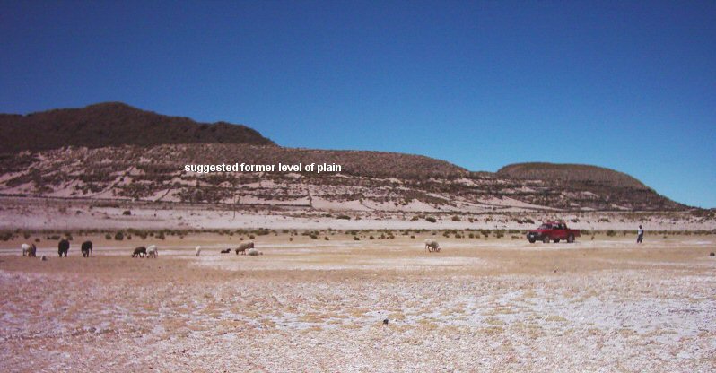
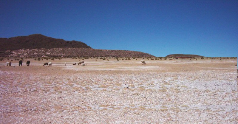
Plato reported that a canal was dug through the surrounding plain to bring boats from the lake to the volcano which suggests that the surrounding altiplano originally had a higher elevation, (making lakes Tauca and Coipasa correspondingly shallower) and today, on site it does appear as if the plain has dropped, leaving the volcano now high in the air. Strand lines around the edge of the Altiplano mark the former levels of the great paleolakes but because they are said to slant from north to south, also confirm that the southern Altiplano has dropped in elevation. If it were possible to establish the date at which the Altiplano sank, that would reveal to us the date of the end of "Atlantis".
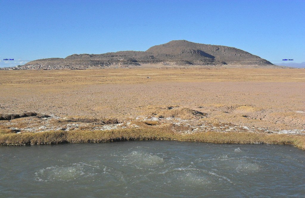
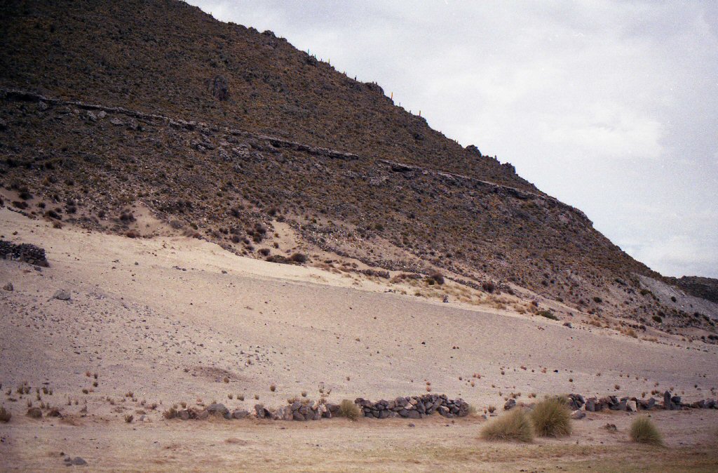
Ground view of the mountain at Pampa Aullagas from the south, (with volcanic spring in the foreground), it is surrounded by a band of stones covered in white, fossilised lake deposits which show the original level of the lake
at a much higher level than today, the surrounding plain has also dropped in elevation.
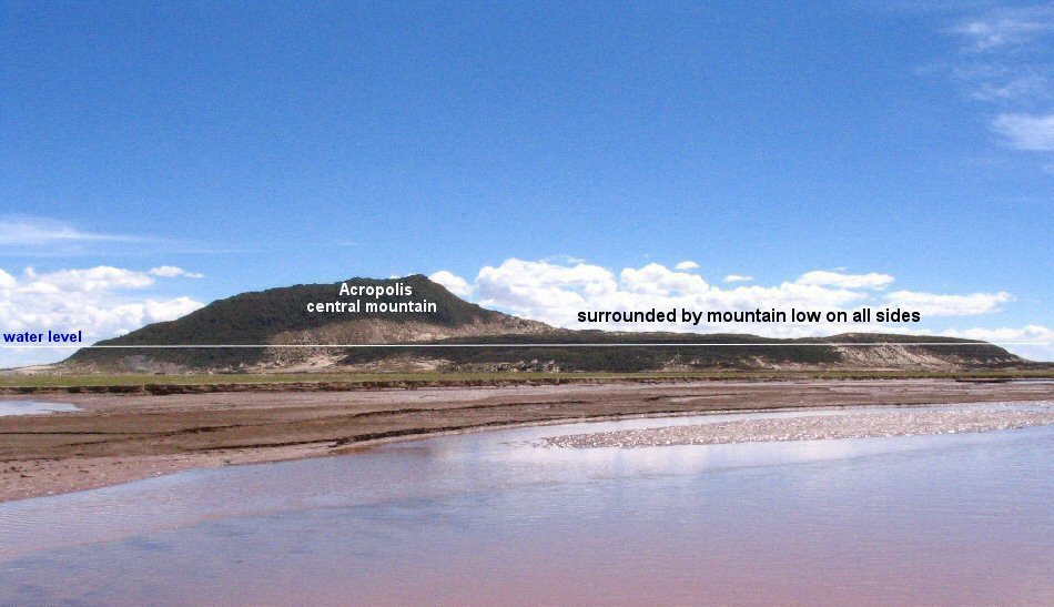
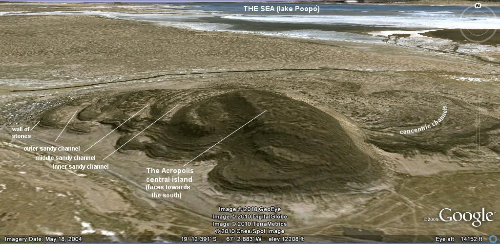
view of the site at Pampa Aullagas from the east showing as Plato called
it "a mountain low on all sides". This refers to the circular volcanic plateau which surrounds the central
cone and which also contains the concentric rings. The fine line marks the ancient water level which would
have filled the sandy depessions leaving circular bands of rock forming rings of land. The white sandy band on the central cone shows
where this part of the cone has fallen away due to earthquakes and the white sand on the sides of
the outer plateau show where the land and level plain has dropped away from the original volcano.
Following on from Lake Tauca or Coipasa, successive wet and dry periods occurred with an extremely dry period from 4,000 – 3,000BC.
However, with the wet period
beginning 2500 – 1900 BC, a paleolake formed in the River Desaguadero valley
suggesting that at this period the water levels might have been correctly
balanced to feed the canals of
Atlantis. It also suggests that Lake Poopo could have formed an almost
continuous sea stretching right up to lake Titicaca.
Following a “short” dry spell of 400 years, the next wet spell was from 1500 – 1200BC offering an alternative possible date for the end of Atlantis since 1200BC is concurrent with the invasion of Egypt by the “Sea Peoples” which could correspond to the war against Egypt which Plato described.
30,000 – 28,000BC Lake
Minchin or 48,000 to 36,000BC
wet 24,000 – 13,000BC
(16,000 – 11,000 = Lake Tauca)
dry 13,000 – 11,000BC
onset of salt deposits Salar
de Uyuni marked demise of paleolake Tauca around 13,000BC indicating that lake
Titicaca had dropped below its outlet level, hence, it no longer fed the
paleolake.
Wet 11,000 – 9,500BC..Lake Titicaca overflowed
again and a paleolake occupied the central Altiplano (paleoake
Coipasa)
Dry 9,500 – 8,000BC
Wet 8,000 – 6,500BC
Dry 6,500 – 5,000BC
Wet 5,000 – 4,000BC
Extremely dry 4,000 –
3,000BC
Wet 2,500 –
1,900BC..paleolake in Rio Desaguadero valley ( a few metres above modern
level)
Wet 1500 – 1200BC
Wet 800 – 500BC
Wet 200BC – 0
Wet 1500AD – present
Lake Titicaca has been at or near its overflow level since about 1500BC and small lakes (such as modern Lake Poopo) have existed on the central Altiplano during much of this period.
above data from Dunbar and Baker, for full report, CLICK here
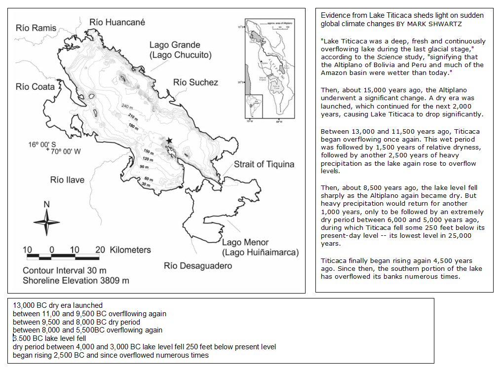
Above, Lake Titicaca contours and overflow dates.
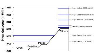
note the two different levels for lago Tauca, 3760metres and 3720 metres, the lower level is sometimes called lago Coipasa.
Lake Tauca, glaciation and lake levels report

Above, scheme of differing lake levels according to Fornari 2001 using Tauca data 1996.
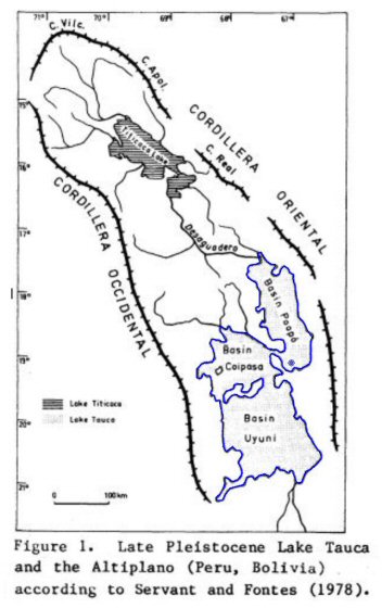
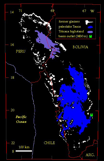
Above left, Lake Tauca according to Servant and Fontes 1978.
right, Atlantis as an island and partly submerged by Lake Tauca highstand.
n.b. differing reports give different data hence occasional descrepancies in figures
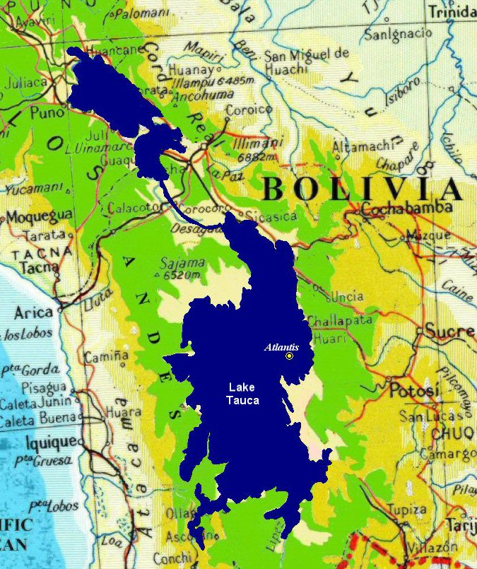
Lake Tauca, (diagram above left), according to a 1983 report by Albrecht Kessler lasted from 10,500BC to 9,000BC and covered the Altiplano to a depth of 60 metres, note how Lake Poopo has enlarged to become an even bigger inland sea while water covers most of the rectangular (Basin Coipasa + Basin Uyuni) plain. When the lake dried up there would have been an optimum time when the plain was covered in fertile alluvial mud
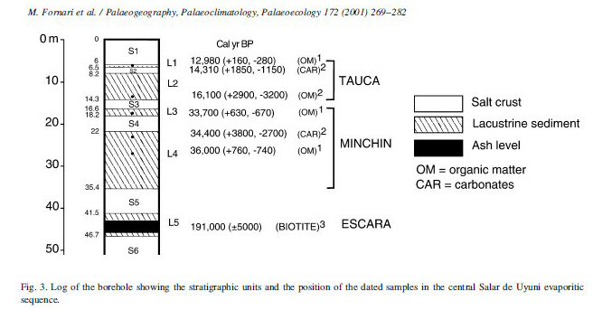
Alternating deposits of salt and lacustrine mud according to Fornari 2001.
- a 2001 report by Michel Fornari gives a date for Lake Tauca of from 14,000 to 10,000BC and a depth of 20 feet for the initial layer of alluvial mud left behind when the lake dried up and before it became covered in salt deposits, other reports give a date of between 11,400BC and 9,500BC for the radiocarbon-dated shallow paleolake called “Coipasa” - a subdivision of the "Tauca" phase and the above chart records a depth of 500mm (20") of alluvial mud left behind by paleolake Coipasa and subsequently buried under 6 metres (20 feet) of salt deposits dating from that period until present day.
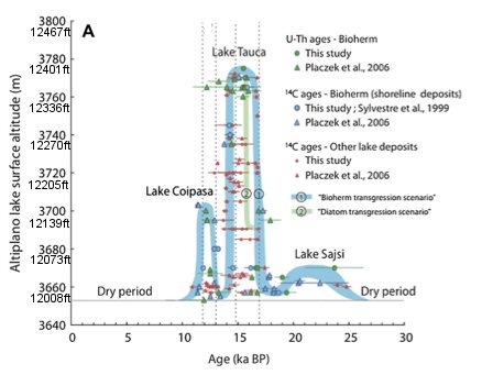
Lake high stands according to Blard 2012
Figures according to Blard 2012, state that the Lake Tauca cycle lasted from 16,000 to 12,500 BC and was characterized by a high water stand reaching at least 3770 m (12,368ft) from 14,500 to 13,000 BC, while the Lake Coipasa cycle according to Blard lasted from 10,500 to 9,900 BC and reached an elevation of 3700 m, (12,139ft) i.e. 42 m (138ft) above the elevation of the Salar de Uyuni (3658 m) (12,001ft). (Analysis of Lake Tauca sandbeach deposits near Nueva Esperanza (20.0495°S, 67.0644°O, 3765 metres, 12,352 feet, region is near northeast shore of Salar de Uyuni)

Lake Tauca highest stand from 14,500 to 13,000 BC according to Blard 2012
Today the plain is covered in salt salars due to the repeated flooding and evaporation of the waters over centuries. So the geological date is correct for an Atlantis culture to have began when lake Coipasa dried up as Plato gave a date of 9,000 years before Solon (9,600BC) and the object of the perimeter canal would have been to prevent the waters of Lake Poopo from encroaching onto the level plain so the canal could be used both for irrigation and to prevent flooding.
At one time the river Desaguadero originally drained the plain from South to North but later changed direction and today drains from North to South. Posnansky followed the strand lines of the former lakes as far south as the lake Poopo region and thought the original lake level was about 170 feet above the present-day level of lake Poopo. In the region of the village of Huari he noticed that the strand lines (which would have formed in a horizontal level) had become inclined but was not sure whether the sinking of the southern zone was a slow or rapid occurance.

Posnansky's interpretation of the strand lines
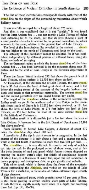
Path of the Pole, Bellamy's interpretation of the strand lines

Carbonate encustrations mark the strand line or level of the former lakes
in this case 140 metres above the salt pans of today's Altiplano according to the USGS.
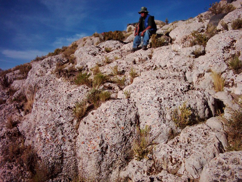
Lake deposited carbonate encustrations on outer wall at Pampa Aullagas.
close-up showing encrusted lake deposits and earthquake damage at Pampa Aullagas.
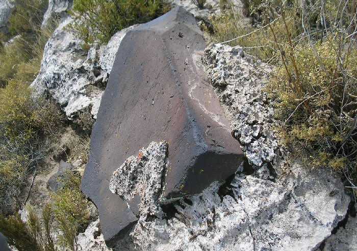
This black stone found fairly high up the southern side of the mountain
appears encrusted with lake deposits.
This line of carbonate encustrations marks a level of the former lakes at Pampa Aullagas
and also shows where the face of the mountain has fallen away due to the earthquakes.
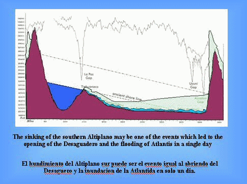
After the earthquakes and floods: did
the earthquakes cause tsunamis?
Did the sinking of the southern Altiplano
cause Lake Titicaca to overflow its banks
and sumberge the southern zone in a
giant tidal wave or tsunami?
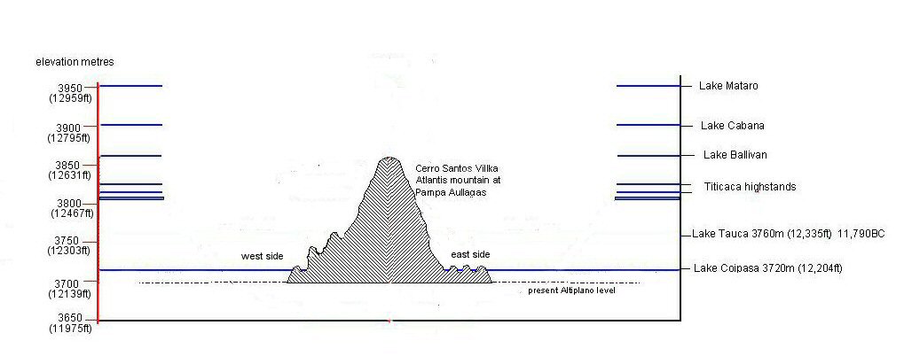
top figure. Lake Tauca
11,000BC. The Desaguadero is horizontal and parallel to the lake level.
Prior
to the arrival of the lake, water drains from the Salar de Uyuni northwards.
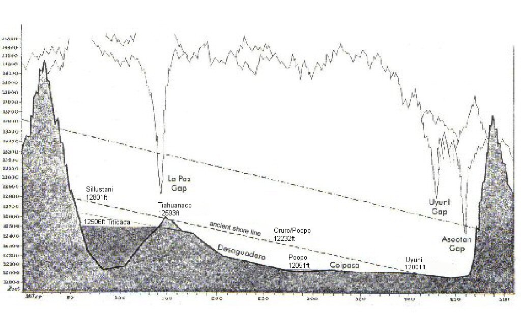
Present day
shore lines according to Bellamy. At some time after lake Tauca in 11,000BC, the northern end has
risen and the southern end has sunk giving the slanted ancient shore lines. Water
today drains from Lake Titicaca southwards to Lake Poopó and Uyuni. Source:
Bellamy "Built Before the Flood" with heights in feet added as per Bellamy's description in "the Path of the Pole" (above).
Posnansky thought that the land in the northern section had risen due to being relieved of the weight of ice which
had melted after the end of the Ice Age.
We can note that the figure for Sillustani is about the same as the modern figure for paleolake
Cabana and the figure for Oruro/Poopo is about the same as the modern figure for paleolake
Coipasa so perhaps Posnansky/Bellamy's figures would benefit from modern verification.
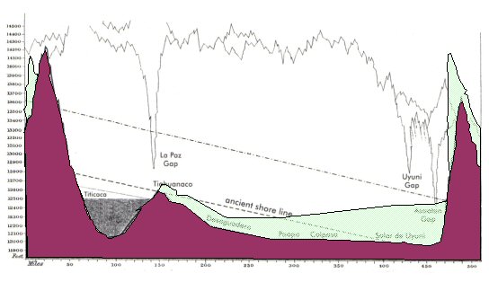
Combining the
two drawings shows how the land has sunk at the southern end.
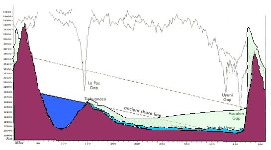
If this happened
suddenly... the water from Lake Titicaca would flow southwards in a giant tidal
wave......
wiping out everything in its path and submerging the island of
Atlantis in Lake Poopo
I should mention also that Plato's date for the end of Atlantis is somewhat ambiguous since he gives the same date for its founding, 9,600BC as he does for its destruction, but in that respect he also refers to the date as being the date when the war began which, since there was no Athens or Egyptian state in 9,600BC probably refers to the invasion of the eastern Mediterranean by the Sea Peoples and subsequent Persian invasion of Greece, dating from the time of the Trojan War around 1260BC down to 480BC when the Persian navy was defeated in the Battle of Salamis marking the turning point of the war in favour of the Greeks. Plato's description of the 10,000 chariots and 1200 triremes of Atlantis is probably also based upon Herodotus' description of the army and navy of the Persians recorded in his Histories since the Persian fleet also had 1200 ships - incidentally again the same number Homer gives for the Greek fleet attacking Troy in the Illiad.
So Plato's story of Atlantis would appear to be a compound story, using geographic data such as a description of South America and the Altiplano along with a description of elements based upon the Persian Wars and a few embellishments provided by Plato himself, thus making it difficult to work out which aspects are true and which aspects may be invention.
The site at Pampa Aullagas corresponds well to the first part of the description of how the god of the sea "broke it off all round about making circular belts of land and sea so that is was impassable to man" but whether there was ever a canal from the sea leading to the outer rings is a much more difficult thing to prove, also with the canal said to run around the perimeter of the plain.
There also existed in Persia two capital cities said to be surrounded by concentric ringed walls, one at Eckbatana (although in modern times no evidence of ringed walls have been found there), the other at Susa and these walls were also said to have been painted in decorative colours and rising higher on the interior towards the centre.

Susa aerial photo, the citadel in the foreground shows remarkable similarity to the site
at Pampa
Aullagas as it exists today. The fort at the rear of the site was built by French archaeologists
and the "Tomb of Daniel" is marked by the pointed spire on the left of the photo.
Oblique view of Atlantis mountain at Pampa Aullagas.
See also Pampa Aullagas page for additional photos of Pampa Aullagas
sailing to Atlantis

atlantisbolivia.org homepage