|
|
||
Atlantis Bolivia - page 2, the evidence
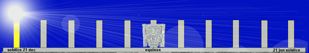
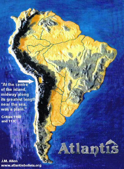
There are certain key features which a site ought to comply with if it is considered to be Atlantis. The location is clearly defined by Plato when he says it is larger than Libya and Asia together and was in the Atlantic Ocean opposite the Pillars of Hercules (Strait of Gibraltar) - therefore that can only mean one place - America. We have already mentioned that it should have been located on a continent opposite the Strait of Gibraltar, but then in the centre of this continent and next to the sea, there should be located a level, rectangular-shaped plain. The translation by Sir Desmond Lee even mentions that the plain was located "midway along the longest side of the island."
So if we discover in America most of the geographic details of Plato's description and we don't find in other locations such as Santorini or the Azores details such as Plato gave, then it is pointless of people to continue promoting Santorini as the origins of the Atlantis tale and ignoring the true location.
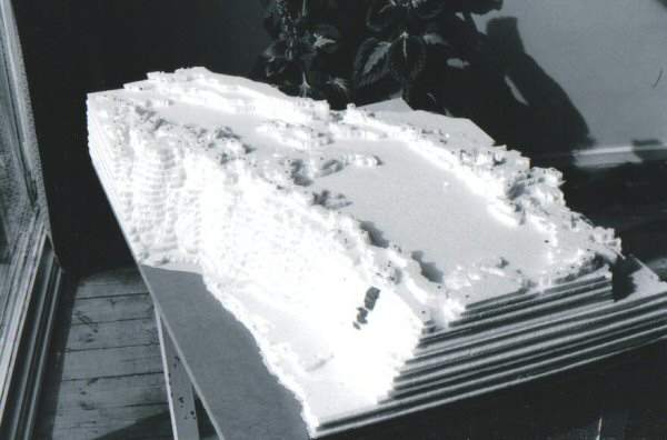
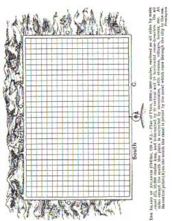
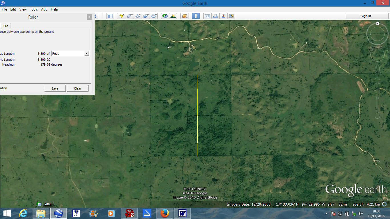
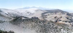
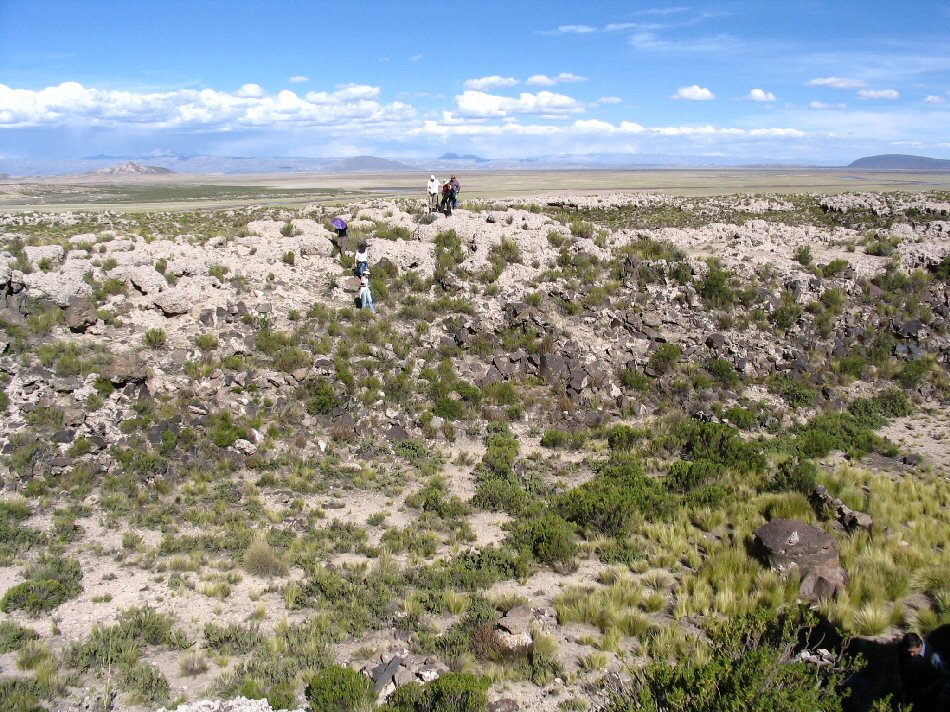
In the beginning, it was necessary to confirm that a smooth and level rectangular plain of the right proportions existed in south America at all. This was done by buying a USAF navigation chart of a scale of 1/1,000,000 and tracing the contours at regular intervals in order to build a three dimensional model which revealed the rectangular shape of the plain.
Above, (left) Fig. 1 the 13,000ft contour reveals the shape of the level and rectangular plain and
(right) Fig. 2 location of the
plain in the centre of the continent, midway along the
longest side and next to the sea.
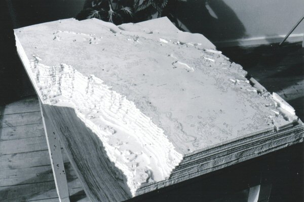
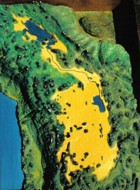
Above, building up the model by stages.
Plato described the plain as "originally a quadrangle, rectilinear for the most part, and elongated".
"It was encircled by mountains, had a level surface and was as a whole rectangular in shape."
"It was originally a long, narrow rectangle."
No other site in the world, whether above water or under water,
has a level rectangular plain in the manner outlined and illustrated above.
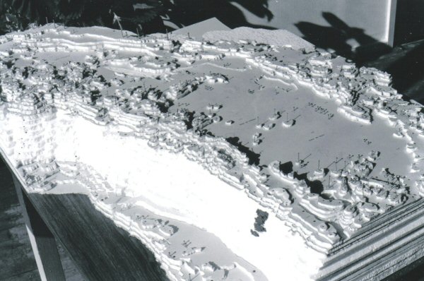
Plato also said that the region was HIGH ABOVE THE LEVEL OF THE SEA, it rose sheer out of the sea to a GREAT HEIGHT, it rose precipitiously out of the sea and was ENCLOSED by mountains.
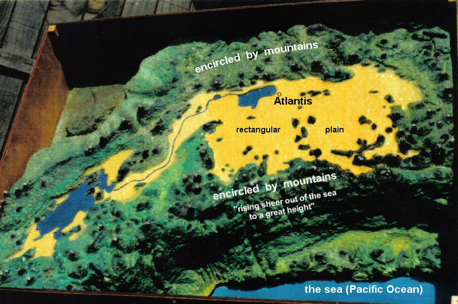
The rectangular plain enclosed by mountains rising sheer out of the sea to a great height.
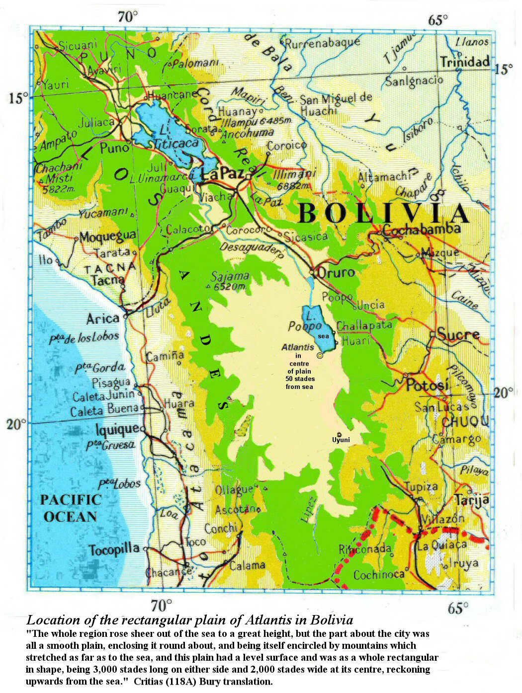
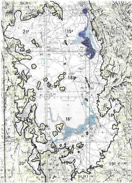
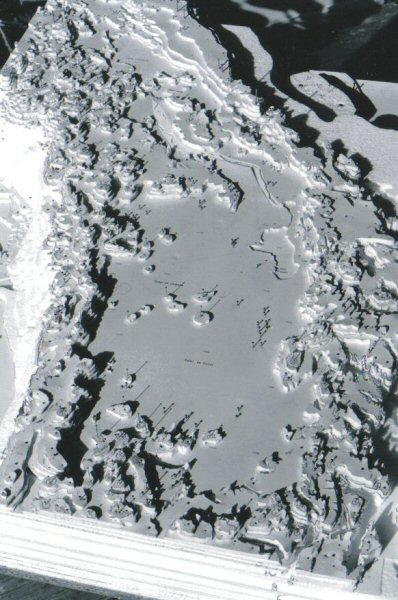
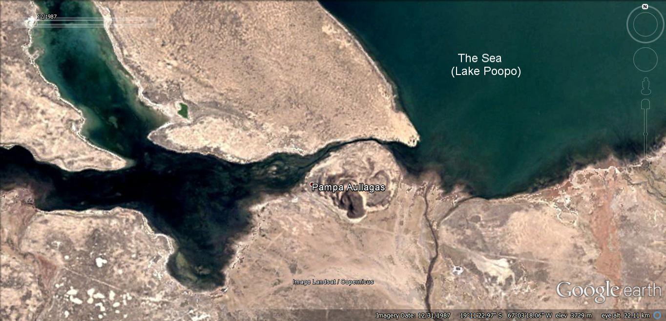
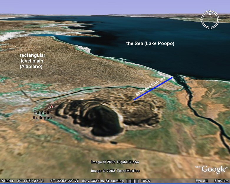
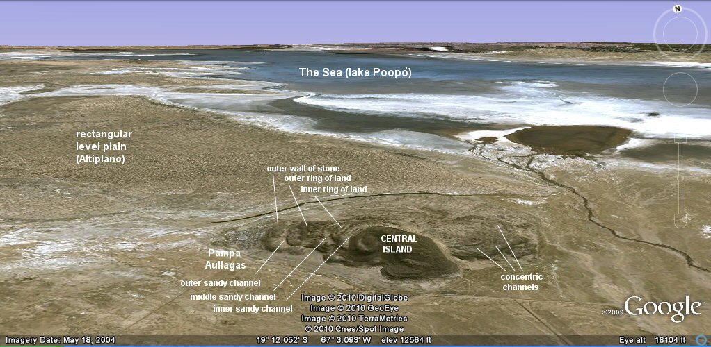
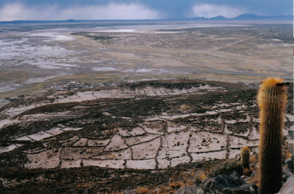
Location of the rectangular level plain with the Atlantis site in its
centre at Pampa Aullagas to the south of Lake Poopo, Oruro, Bolivia and showing the location
... "50 stades" or about 5 miles from "the sea".
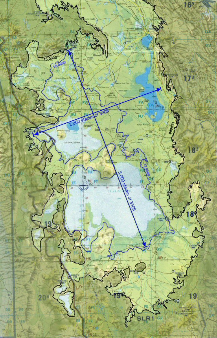
The rectangular plain next to Lake Poopo is in the correct proportions of 3,000 x 2,000 stades using
a 330ft stade. Modern mapmakers have chosen to show contours at intervals of 1,000 feet, so the above map shows a view of the
plain defined by the 13,000 foot
contour, with inset, a blue line defining the 12,000 foot contour. In the wet season, water gathers at the southern end of the
plain more or less along the 12,000 foot contour and the Salar de Uyuni becomes a large lake.
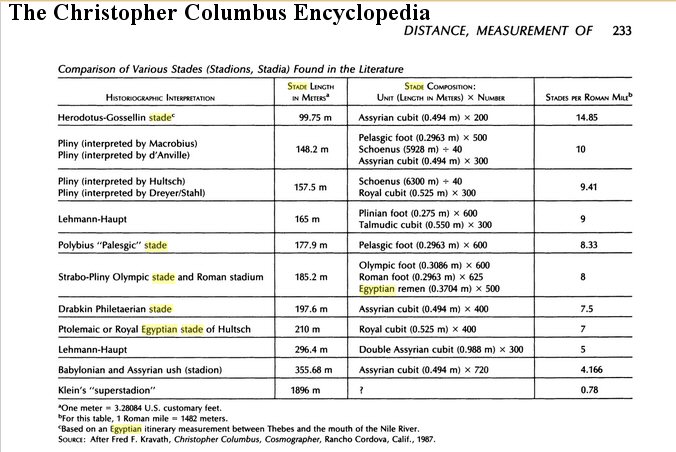
This table from "The Christopher Columbus Encyclopedia" lists a stade of 200 cubits identical to that found for the
length and breadth of the rectangular Altiplano and shows such a stade was also used in Assyria.
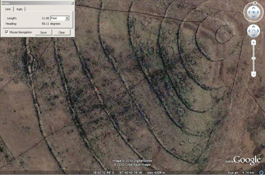
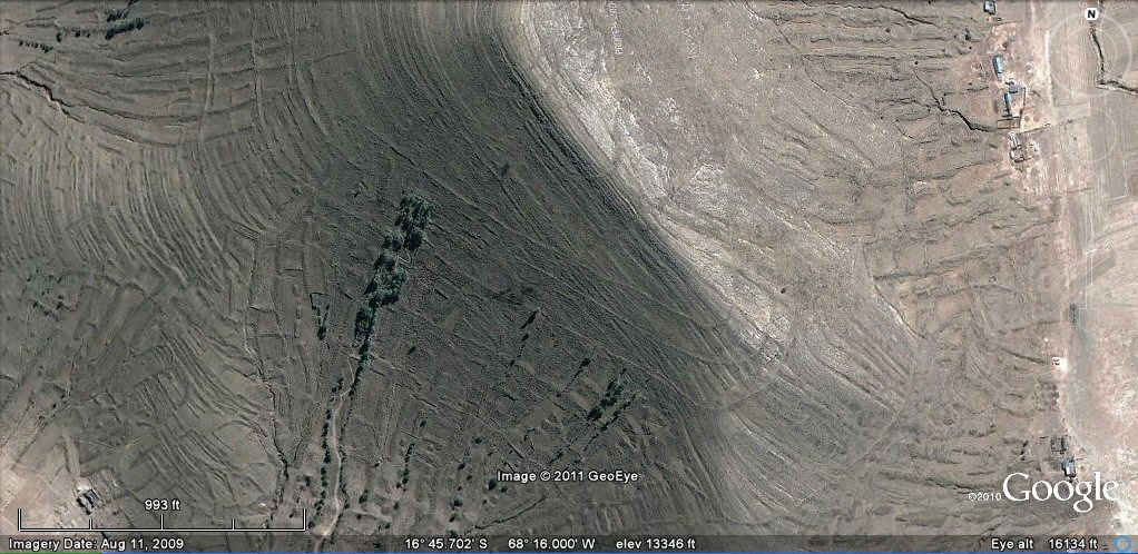
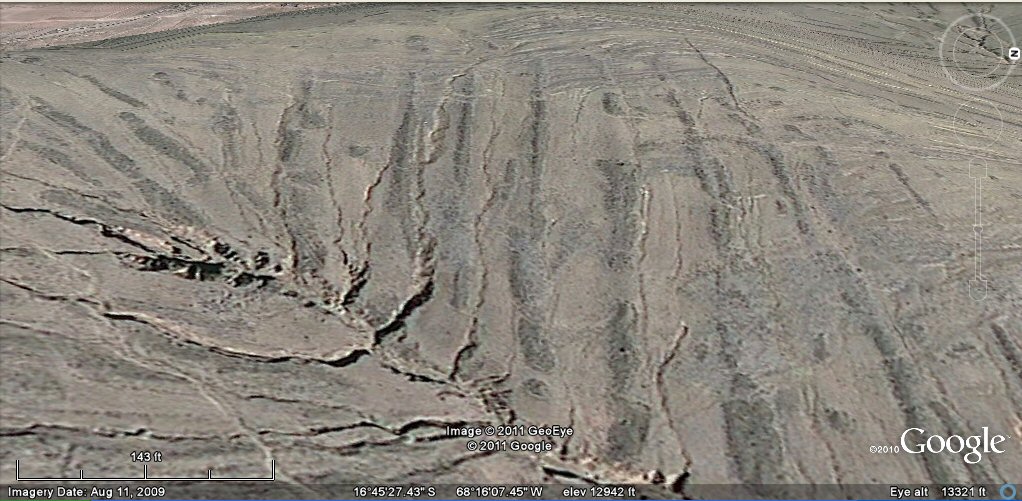
Another of the key features described by Plato, was a large canal which ran around the perimeter of the level plain and a system of smaller canals parallel to each other which criss-crossed the plain at regular intervals.
The parallel canals were intersected by a system of lateral canals usually assumed to be at right angles and used by boats for the transportation of the season's products so the plain is usually shown as divided into squares of 100 stades and these were also divided into allotments of 10 x 10 stades.

Above left, traditional drawing of the plain and canal system with
Atlantis at its centre. Note the wide, perimeter canal and the smaller criss-cross canals forming squares of 100 stades.
Above right, Artists impression of the Altiplano with theoretical canals for comparison to LOEB map
and showing the location of Pampa Aullagas where the city should be.
n.b. it is the plain which measures the 3,000 x 2,000
stades and the canal system
is assumed to be a regular rectangle in the LOEB drawing whereas the volcanic outcrops on the Altiplano
seen on actual topographical map suggest the perimeter canal is more likely to have "wound its way around
the plain" in a more irregular fashion as described in some translations of Plato. (Jowett).
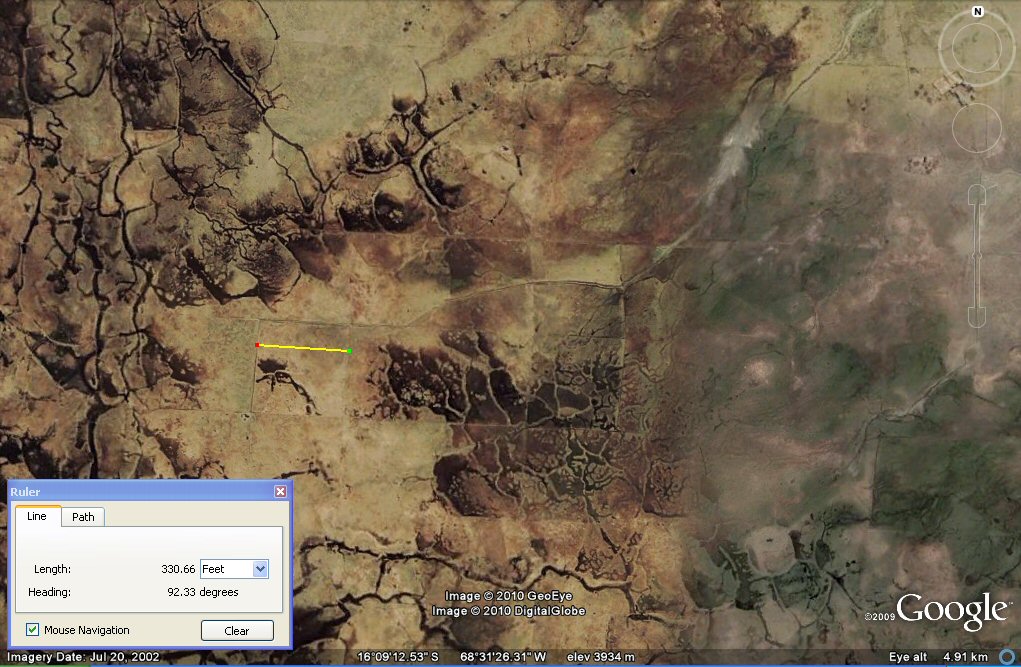
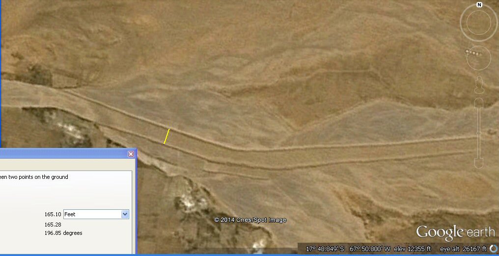
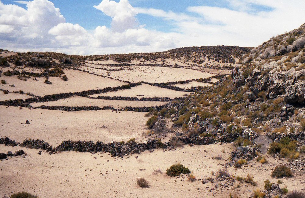
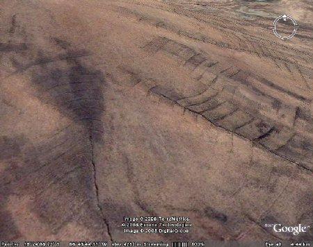
At last the Altiplano gives up its secrets! These channels on the Bolivian Altiplano north west
of La Paz region are in regular plots of 330ft
confirming the use of the 330ft stade to describe
the rectangular plain next to Lake Poopo whilst the 165ft stade (100 Sumerian cubits) as
found in Tabasco was used to describe the ringed city.
The plain was reported to be divided into allotments of 10 x 10 stades with the main canals
at 100 stade intervals so there would be 100 plots of 330ft x 330ft per 100 stade square, and each
could therefore be divided into 4 blocks of the smaller 165ft x 165ft stades (100 x 100 cubits),
making 20 x 20 sub-holdings of land per allotment.
CLICK for Atlantis Stade page
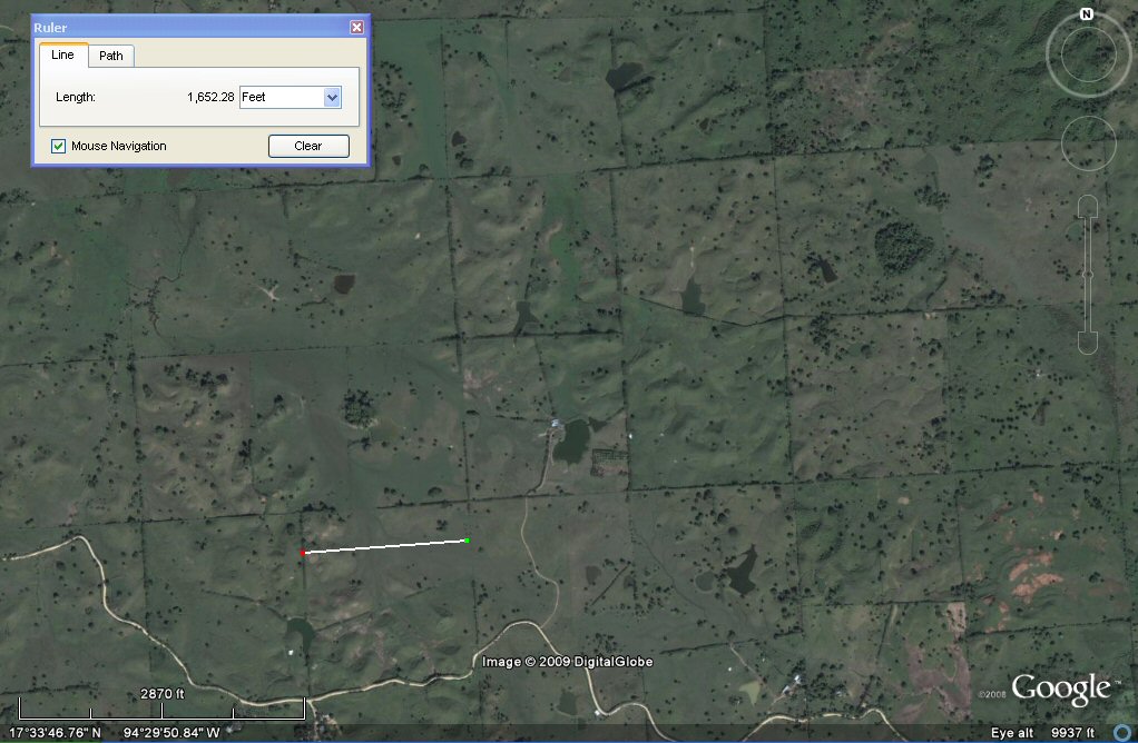
These square plots of 10 x 10 stades of 165 ft (1,000 x 1,000 Sumerian cubits) in the Tabasco region of Mexico provide the key to the Atlantis stade
CLICK for Tabasco canals page
In the Tabasco region, plots of 3300 x 3300 ft are found making them 10 x 10 stades of 200 cubits per side with a
stade similar to that found
on the Altiplano. Alternatively we could think of a block of 4 of the 10 x 100 cubit plots as making up the 10 x 200 cubit plots.
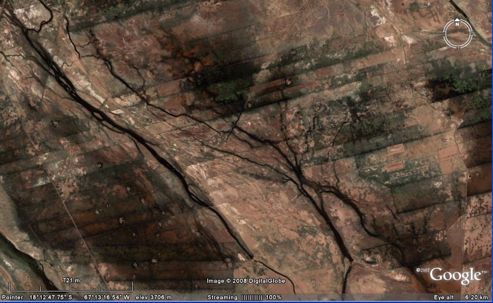
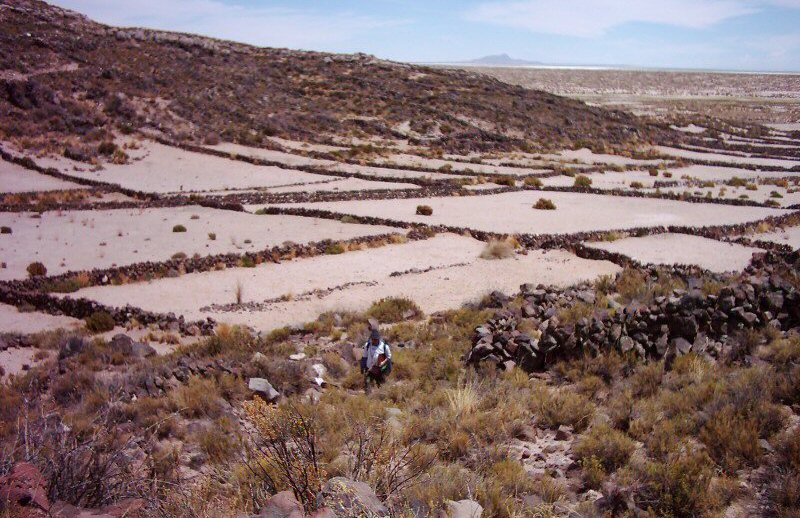
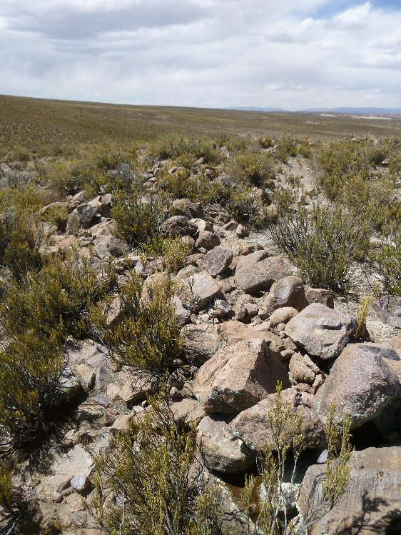
Looking for evidence of a canals system on the Altiplano has been a key feature in the search for evidence. The presence of canals was denied for a long time by the "experts" such as Simon Lamb of Oxford University, according to geologist Simon Lamb, there are no canals on the Altiplano. Well, at least that's the impression this review of his book "Devil in the Mountain" tells us.
"Simon Lamb, a geologist at Oxford University, got a call one day from a television producer about pictures of Atlantis. The lost civilization could be found on 12,000-foot high plains nestled in the Andes Mountains. An Atlantis expert (whatever that is) had shown the producer satellite photographs of the plains, pointing out canals running in parallel straight lines for miles. What more proof could one ask for? The producer called Lamb, an expert on the Andes, for confirmation. Lamb pulled out his own satellite photographs, found the canals, and laughed. He told the producer that canals had formed naturally, without any help from Atlanteans. Hundreds of millions of years ago, before the Andes existed, rocks had slowly piled up in layers. Later the rocks were heaved onto their side and raised up thousands of feet, whereupon rain began to flow down their exposed flanks. The water gnawed away at the weakest layers, creating a series of straight-edged channels. As he spoke, Lamb could sense hostility on the other end of the line. The producer didn't want to hear about strata and erosion. ''Well, that's your explanation, anyway,'' he huffed, and went off to make his documentary without Lamb's help. ''Atlantis in the Andes'' later appeared on the Learning Channel.
On the other hand, if you want an unbiased opinion you could log into Google Earth and see the canals for yourself or check out the ground shots below...
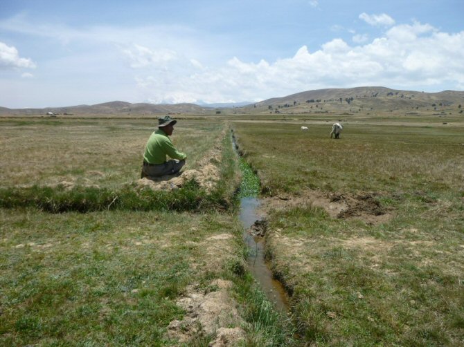
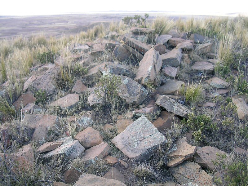
The smallest subdivision of one stade square is divided by smaller channels.
Ground view of the above channels which divide the zone into square plots,
some are still maintained for use today (above) whilst others are abandoned.

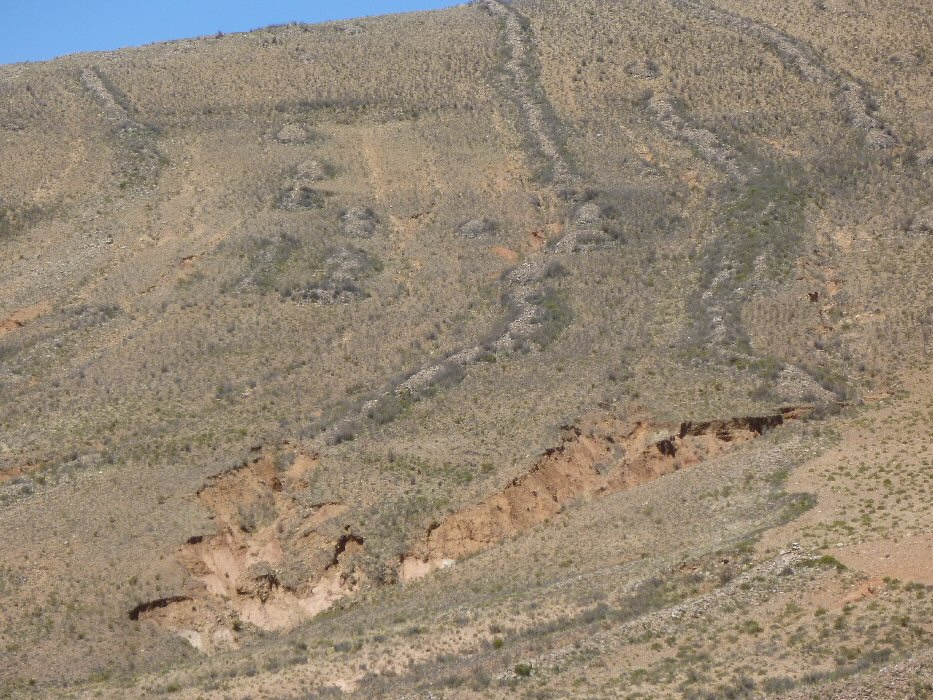
Porfirio Limachi points out overgrown channels at this intersection.
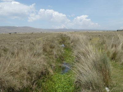
Other channels are wider such as the overgrown example (left) and the redug example (right).
Others such as near Chipaya on the level plain are still wider.
Plato: "Canals were dug in straight lines across the plain."
Recent high resolution satellite imagery shows the area just south of Oruro to be completely covered in a system of parallel canals similar to Plato's description.
Canals are certainly a feature of the area which still suffers today from alternating drought and flooding.
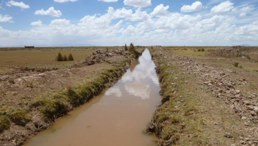
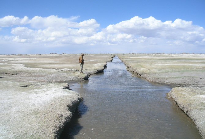
The image below shows remains of another section of giant canal 200ft wide just north of Oruro.
Satellite images showed a very large channel similar to the giant canal
which Plato described just to the west of Lake Poopo and when this was
visited on site,
it still had water in the base due to the fact that the channel was
supplied by water from wells drawing water from underground sources.
Plato: "It seems incredible that the canal should be so large as the account states, but we must report
what we heard..."
Plato mentioned that in Atlantis they cropped the land twice a year and some people think that because today
the Altiplano climate is often described as harsh and soils as poor, that it was always like that. Apart from the effects
of climate change, the destruction of the original agicultural systems was mainly due to the efforts of the Spanish
conquistadors who removed people from the land and sent them down the mines in their quest for gold and silver. The original
agricultural systems
became abandoned and forgotten about, but Google Earth shows that vast areas of the
Altiplano were at one time originally cultivated using a variety of agricultural systems perfectly adapted
to the terrain.
When the abandoned system of agricultural called "suka kollus" or "camellones" was revived as
a scientific experiment, it was found that these heaped up beds surrounded by water channels increased the local
temperatures
and prevented the crops from dying off due to frosts, yields were greatly increased including two crops a year due to the nutrients heaped
onto the land platforms from the water channels. The raised platforms also helped prevent the crops from being
carried away in the flood seasons, both on the Altiplano and the Beni regions.
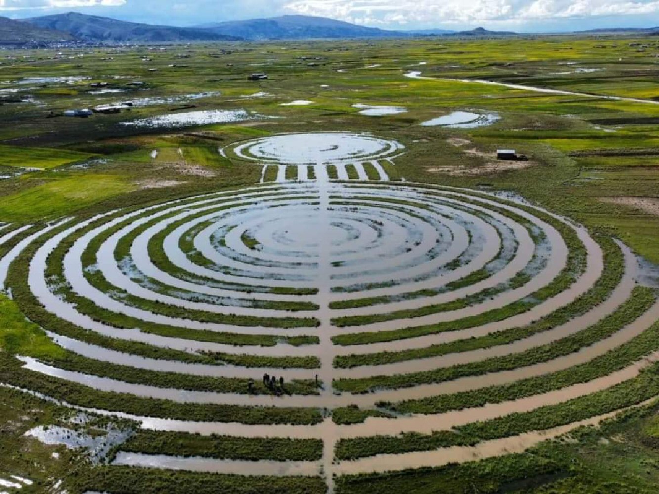
"Potato yields on experimental raised fields ranged from 5 to 20 MT/ha;
traditional agriculture on the slopes yields 2–5 MT/ha (Erickson 1996; Kolata et al.
1996). Based on potato production between 1981 and 1986, I calculate a carrying
capacity of 37.5 persons/ha of raised field cultivation platform or 2.25 million inhabitants
for the entire raised field system." reproduced from "THE LAKE TITICACA BASIN -
A Precolumbian Built Landscape", by Clark L. Erickson
Restored raised field production was therefore up to four times more productive than
traditional methods used on the Altiplano today.
When Plato mentions all sorts of fruits and products available in the island, he is talking about
the entire island continent, not only the Altiplano region and
you only have to visit
any local market in La Paz or Oruro to see the vast selection of natural products brought to the Altiplano from
other regions of the continent, the nearby region of Cochabamba being a typical centre for cultivation of
"exotic fruits".
It took five expeditions on the Bolivian Altiplano following
Plato "near the plain, over against its center, at a distance of about 50 stades, (from the sea)
there stood a mountain that was low on all sides."
"after crossing the three outer harbours, [117e] one
found a wall which began at the sea and ran round in a circle, at a
uniform distance of fifty stades from the largest circle and
harbour, and its ends converged at the seaward mouth of the
channel. The whole of this wall had numerous houses built on to
it, set close together;"
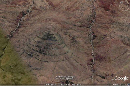
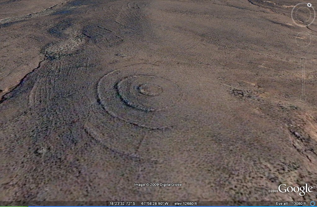
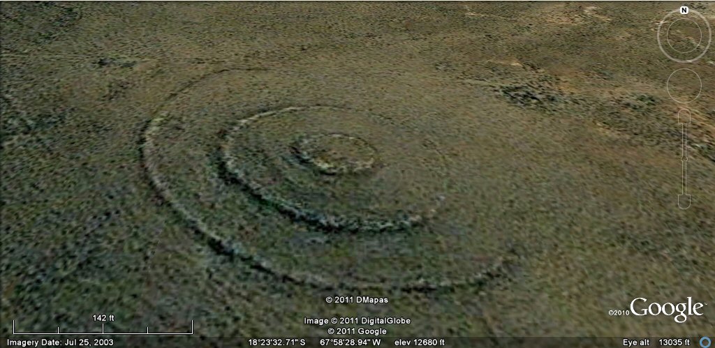
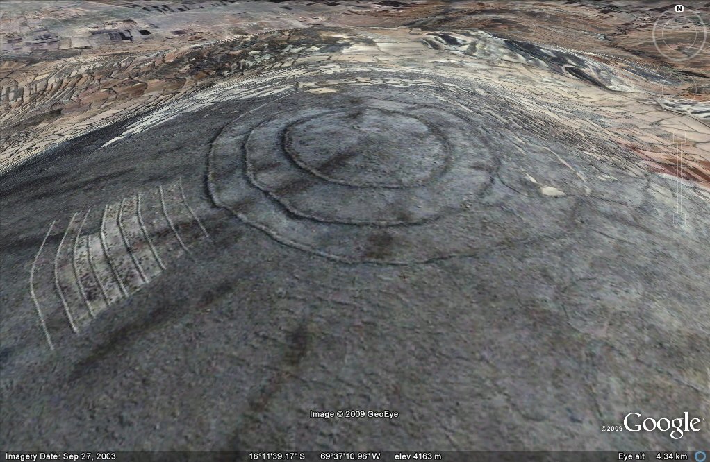
THE most distinguishing feature of Atlantis and one which even the
Milos international Atlantis conference doubted might exist, was that
the main island of Atlantis which Plato described first of all as the
home of Poseidon and later as the site where the city of the
descendants of Atlas reigned, was comprised of a central island
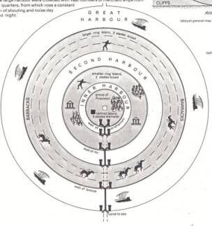
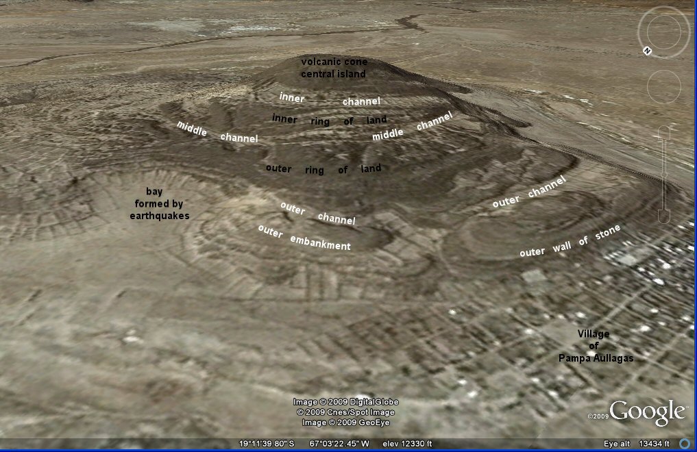
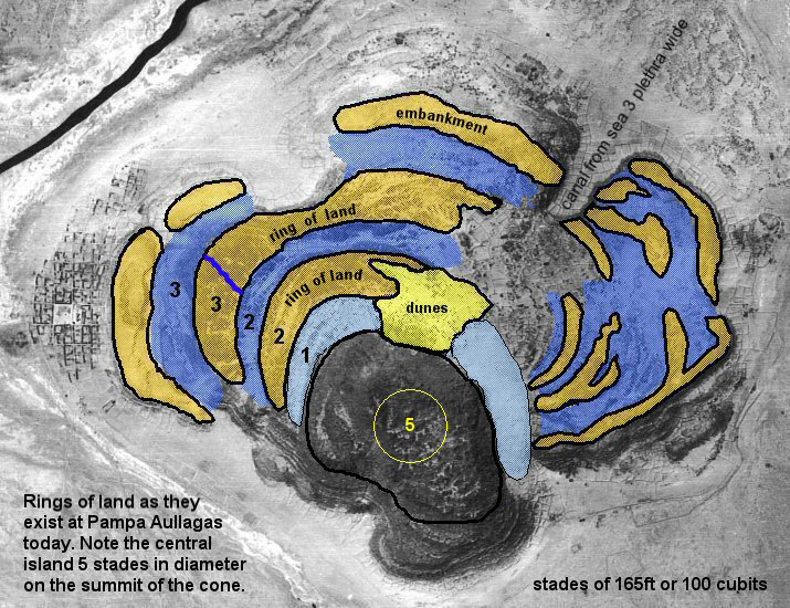
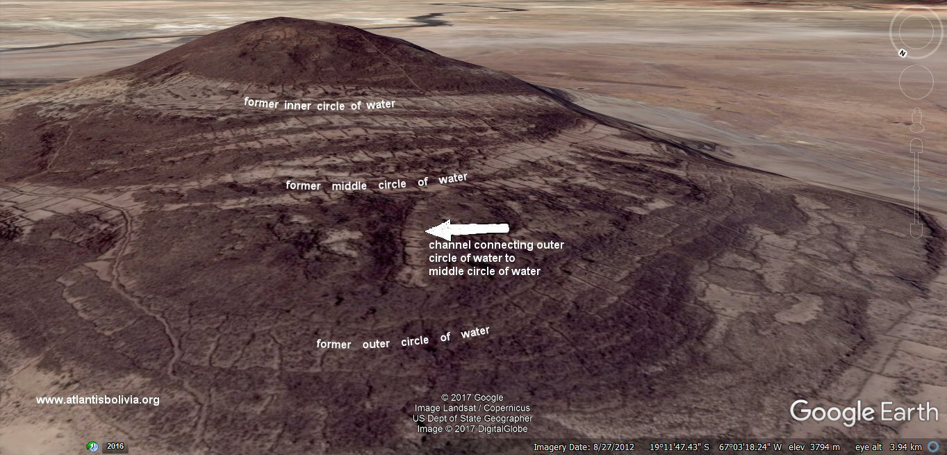
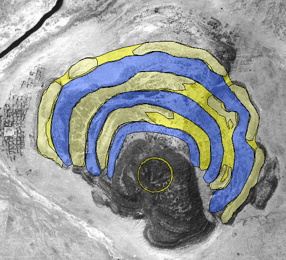
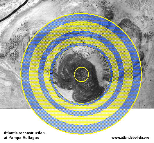
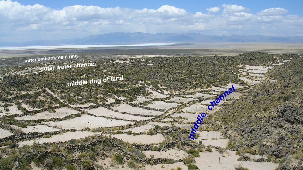
surrounded by alternating rings of land and water.
The island comprised a central island 5 stades in diameter
surrounded by three rings of water and two rings of land, "enclosing
each other like cartwheels."
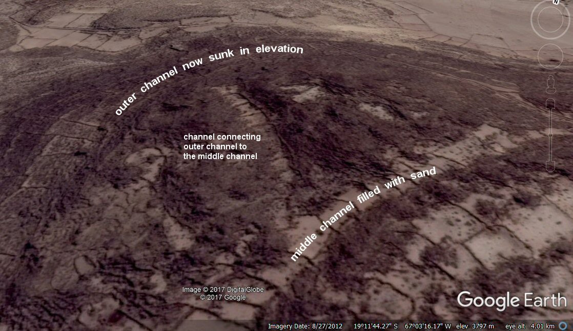
The
innermost channel, 1, is now at a higher level up the volcano
so it is not clear whether this was originally part of Plato's scheme
or whether this part of the island has risen in elevation, perhaps pushed upwards by the earthquakes, or there may
have been another ring of water surrounding the volcano on the level
plain. However, Plato did say the circular rings were "carved out of
the island" and that they "bored through the rock" to reach the outer
circle of water, so logically there should have been a ring of land or
rock
on the outside to contain the outermost water circle, shown above and below as the
embankment just behind the village of Pampa Aullagas, between the
village and water ring 3.
"beginning at the sea, they bored a channel
right through to the outermost circle, which was three plethra in
breadth, one hundred feet in depth, and fifty stades in length;
and thus they made the entrance to it from the sea like that to a
harbour by opening out a mouth large enough for the greatest ships
to sail through."
The
site appears to have suffered considerable damage from earthquakes.
Some parts have sunk, others risen in elevation whilst others appear to
be twisted round and even moved sideways, as if struck by a huge force
from the west and north. (Probably a large volume of water cascading like a tsunami down from Laka Titicaca).
In the above photo, the outer ring of rock has
been joined up and the eastern arm of the volcano moved closer into the
centre to align the canals and show how it may have looked using stades
of 165ft. The rings fall in the correct proportions of 1 stade of
water, 2 stades of land, 2 stades of water, 3 stades of land and 3
stades of water. The centre island 5 stades in diameter is shown to
scale at the top of the steeply sided volcanic cone which is about 5
stades in diameter on the summit and possibly 10 to 20 stades in diameter at its base.
"There
were two rings of land, and three of water, which he turned as with a
lathe, each having its circumference equidistant every way from the
centre"
It is not known whether the outer ring of rock may have continued on the southern side but it seems probable
that it did and was subsequently destroyed by the earthquakes which sank the island, shown
here in this reconstruction. This would explain why the inner ring higher up the mountain ends abruptly on the south side instead of continuing around the mountain.
As to the perfectly circular canals we had imagined based on
popular drawings, I looked up Platos words again and he said in the
beginning..... "Near the plain at a distance of 50 stades (from the sea) there
stood a mountain that was low on all sides. And Poseidon, to make the hill
impregnable broke it off all round about; and he made circular belts of sea and
land enclosing one another alternately, some greater, some smaller, two being of
land and three of sea, which he carved as it were out of the midst of the
island." Critias 108E-121C (the Jowett translation reads "Poseidon ....
breaking the ground enclosed the hill all round, making alternate zones of sea and land
larger and smaller, encircling one another") And that was what we found, except
that the sea had dropped and the "zones of sea" were now sandy bottomed
depressions.
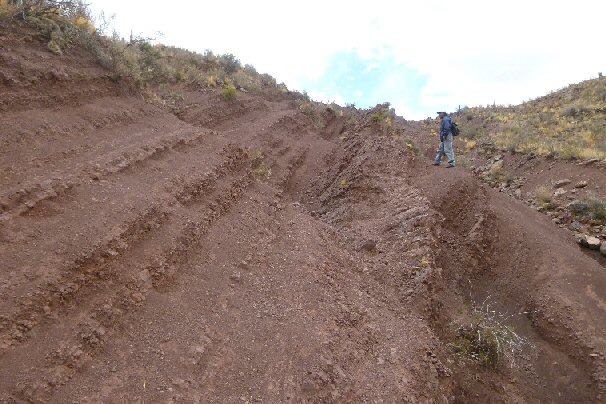
This section of old canal 165ft wide brings waters down from the mountains...
165 feet is one Atlantean stade of 100 Sumerian cubits, about 50 metres.
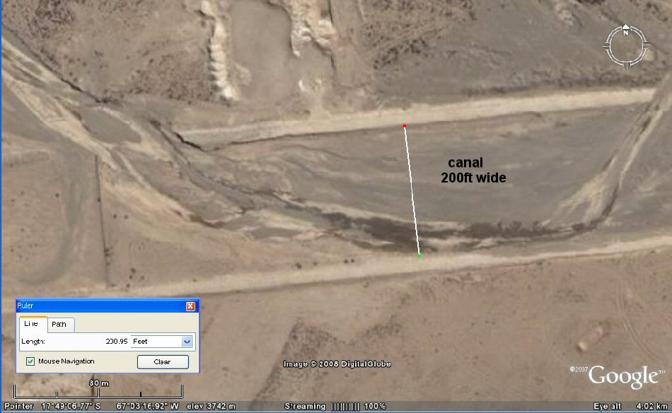
The satellite technology measures this canal section 200ft wide.
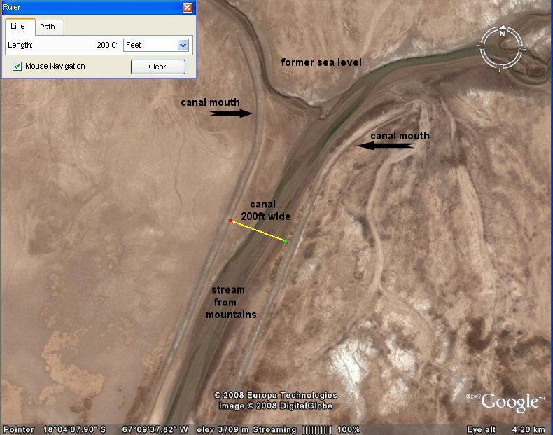
The satellite technology measures another canal 200ft wide,
discharging into the sea, lago UruUru (Lake Poopo). Although not as old as Plato's date,
this more recent canal shows how what Plato described is typical of the region.
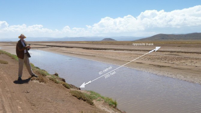
Ground view of the above canal section containing waters of the rio Desaguadero. Seen here half full, this 200ft wide channel stretches from the nearside embankment to where it is marked "opposite bank".
The purpose of this particular canal is also to prevent the adjacent fields from being flooded in the wet season.
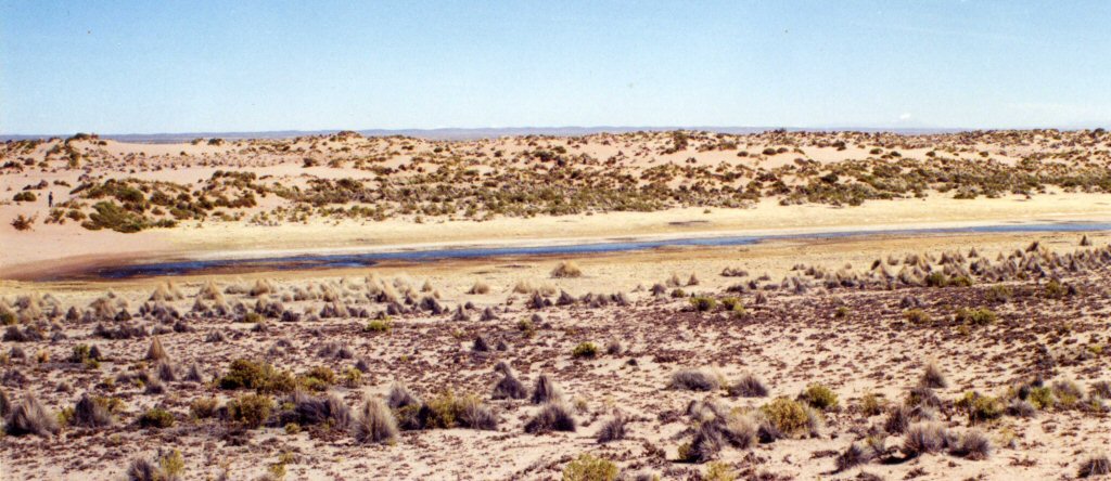
Looking into a section of giant channel about 350ft to 600ft wide
similar to the channel which Plato said ran right around the plain. Its route is sustained by underground
springs and has a ribbon of water even in the height of the dry season.
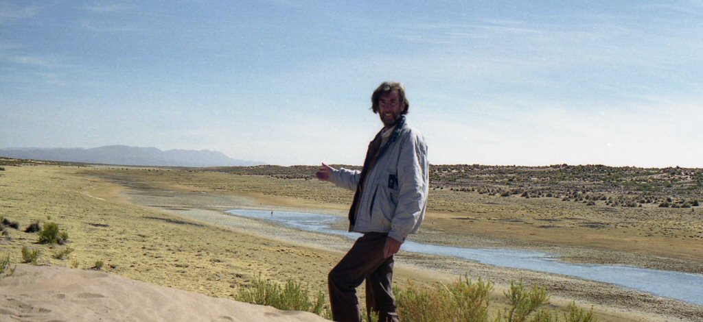
Ground view showing the flat base and sloping sides of the wide channel, whether man-made or natural fault line it remains a unique feature of the area.

Suka kollus or raised fields on the Altiplano
above, typical selection of exotic fruits available in Oruro market.
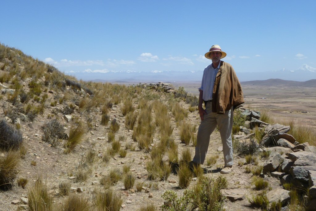
 The Atlantis Trail
to find a location
which matched Plato's mountain which was low on all sides and in the centre of
the plain next to the sea. This site is presently called
Pampa Aullagas at the southern end of Lake Poopo.
 Atlantis as an island
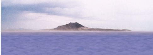
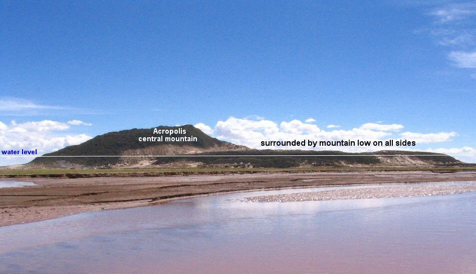
In the wet season, Pampa Aullagas becomes an
island
and before the sinking of the surrounding plain, the water from
the lake could have entered the volcano,
filling the natural depressions
making circular canal-like harbours.
above, in 1987, the sea advanced to the rim of the volcano, a little higher and Pampa Aullagas would have become an island once more.
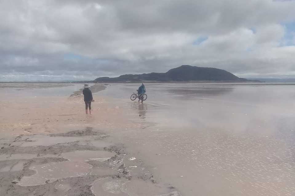
In 2004 Pampa Aullagas became an island in the rainy season.
Atlantis - the sea wall at a distance of 50 stades
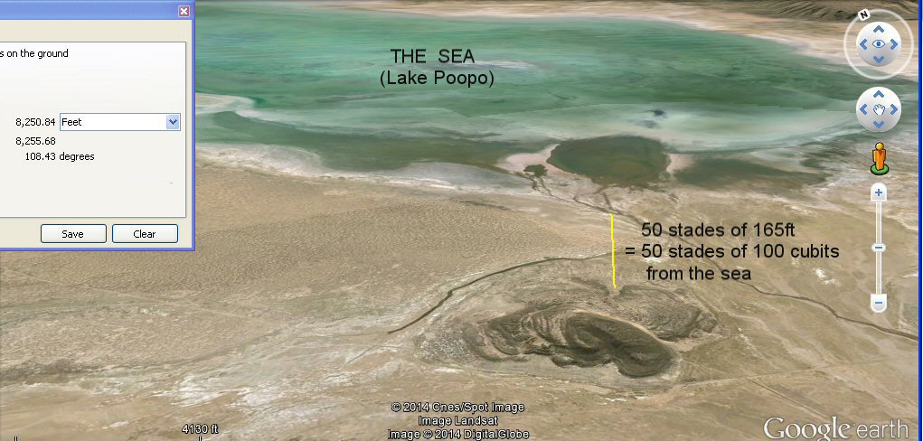
the satellite measures the distance from the sea - 50 stades of 100 cubits (50 x 165 feet).
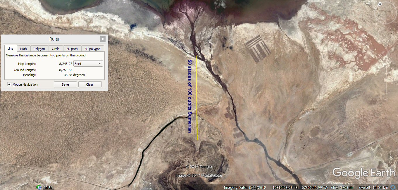
the satellite measures the distance from the sea - 50 stades of 100 cubits (50 x 165 feet).
The level of the sea, Lake Poopo has slightly receded in this photo.
The volcanic cone, 5 stades in diameter lies in the centre of the level rectangular plain,
50 stades (1.5 miles) from the sea
and is enclosed by three concentric sandy channels which formerly held water, separated by rings of land.
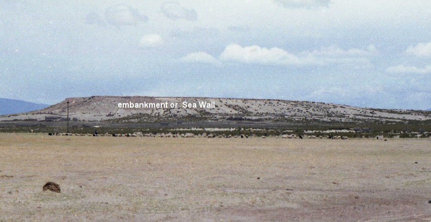
Ground view of remains of the sea wall at a distance of 50 stades of 100 cubits (50 x 165 feet)
from the outermost ring at Atlantis Pampa Aullagas.
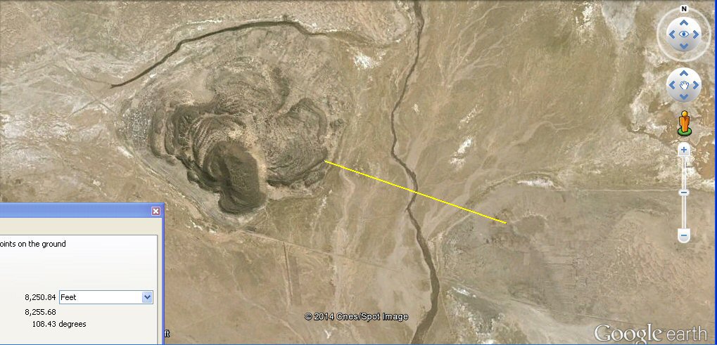
the satellite measures the distance of the sea wall from the outer ring
8250 feet = a distance of 50 stades of 100 cubits (50 x 165 feet)
from the outermost ring at Atlantis Pampa Aullagas.
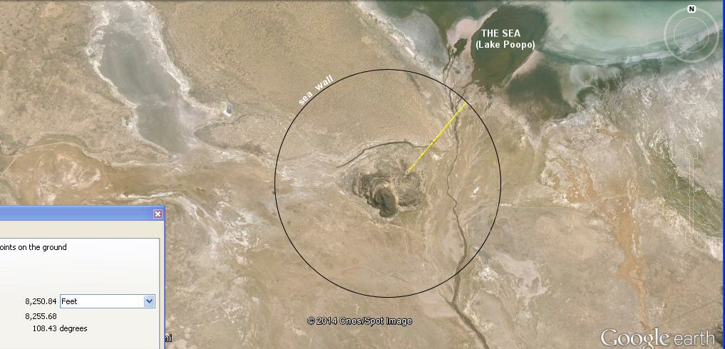
The sea wall ran round the central island at a distance of 50 stades of 100 cubits (50 x 165 feet)
from the outermost ring at Atlantis Pampa Aullagas.
We assume that the purpose of the Sea Wall was to prevent flooding of the land around the city in the wet season, but as Atlantis was a water based culture, it could equally be that the Sea Wall
was used to retain water around the city in the dry season when the lake receded, the houses were reportedly built upon the sea wall and not the land next to the city...
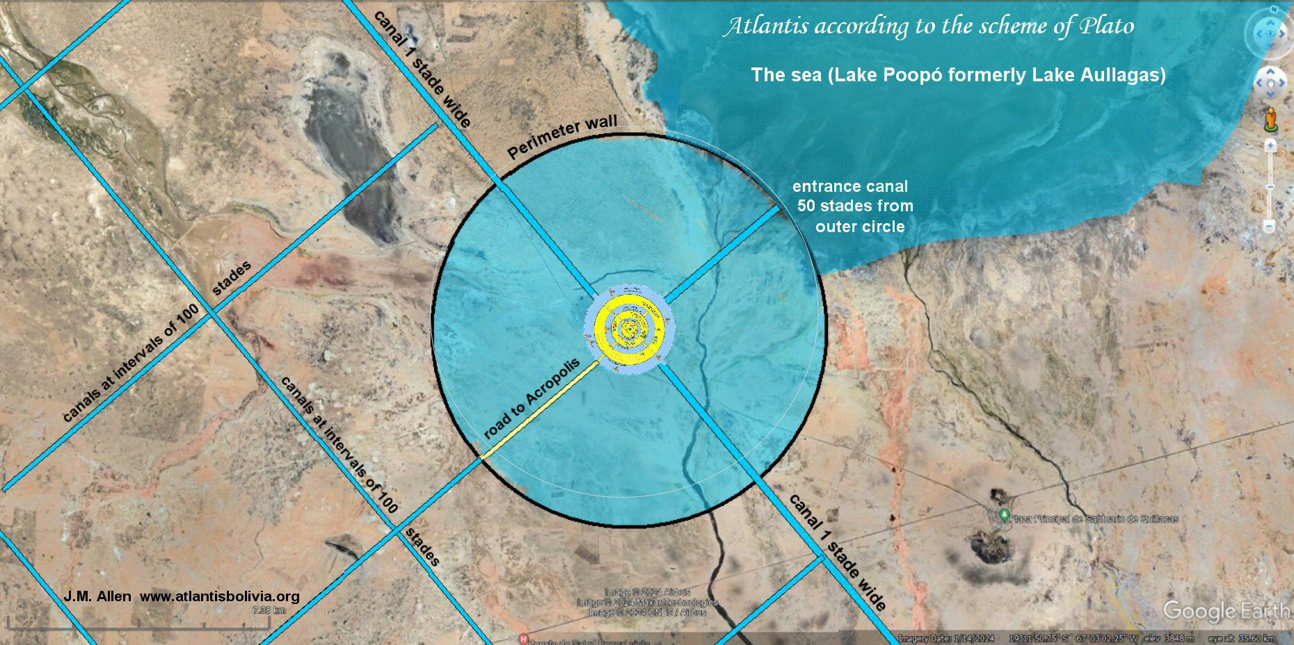
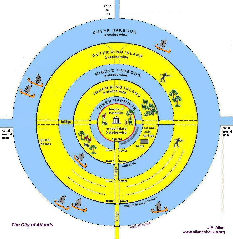
above, Plato´s scheme of Atlantis with a canal one stade wide circling around the level plain and approaching the city on either side to discharge
there via a canal three plethra wide into the sea.
Canals were also dug at regular intervals across the plain and these intercepted by other channels to form transverse passages usually assumed to give a chequerboard appearance.
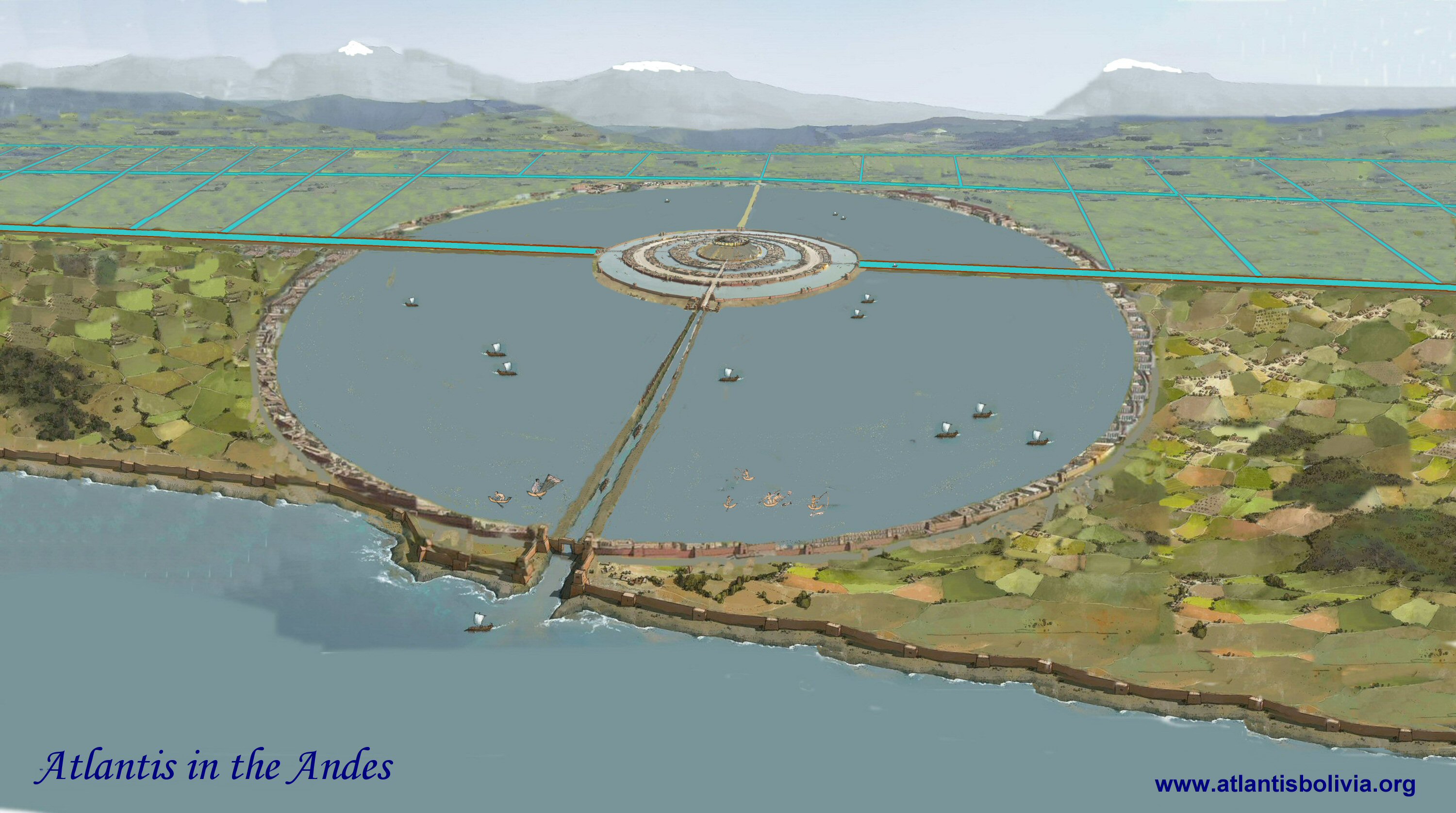
above, Artist's interpretation of how the city may have looked.
On the landward side, a road was built to the central island. On the seaward side, a canal was dug to the centremost channel.
On the plain itself, a canal was dug right around the whole plain and aproached the city on either side, discharging into the sea
via the city's canal to the sea.
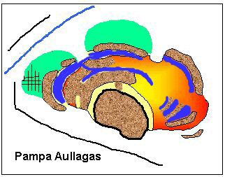
above, Oblique satellite image showing the volcanic island at Pampa Aullagas in the dry season.
The surrounding plain has sunk in elevation and the nearby inland sea has receded leaving the island
as a volcano on dry land.
Atlantis - alternating rings of land and water
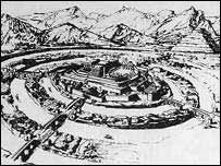

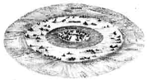
above, two popular concepts of Atlantis showing concentric rings of land
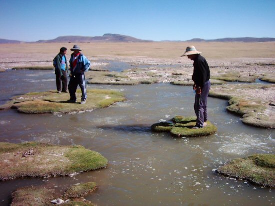
The Uru/Chipaya village in the Salar de Coipasa had a
concentric organisation similar to that of Atlantis.
Above left, traditional drawing of the city with rings of land and
sea.
The central island was said to be 5 stades in diameter, surrounded by a ring of water 1 stade wide,
then a ring of land of 2 stades and a ring of water, 2 stades, then a ring of land 3 stades in turn enclosed
within a ring of water 3 stades wide.
Above right, Illustration of Pampa Aullagas showing remains of rings of
land and sandy canals when filled with water..
the island city of Atlantis
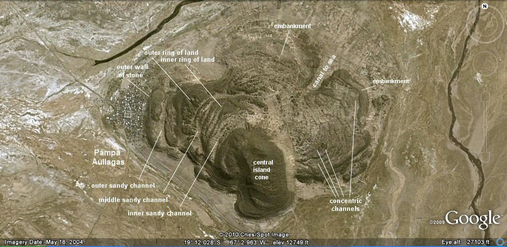
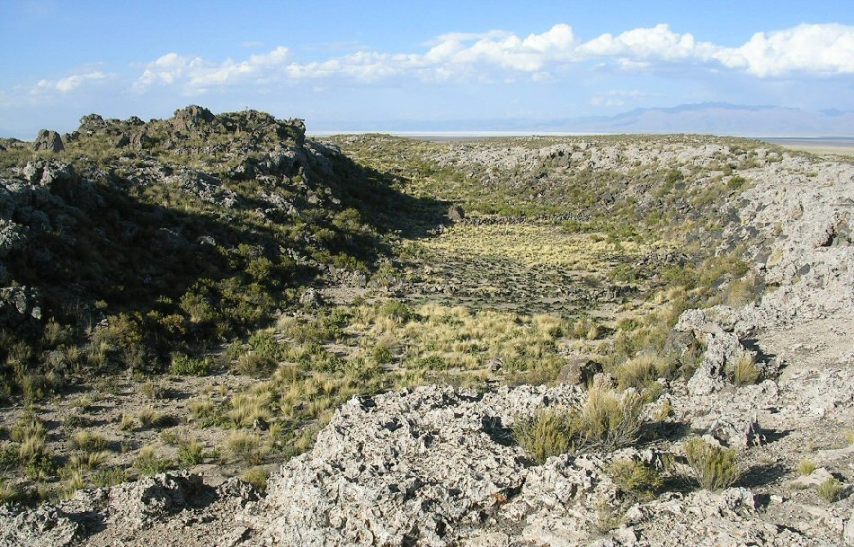
Vertical image showing the remains of three sandy channels separated by rings of land on the volcano to the east of the village.
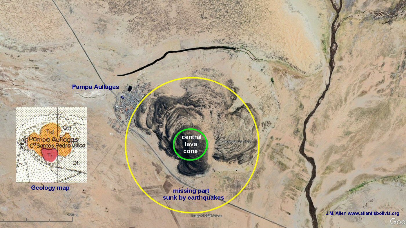
Pampa Aullagas, the volcanic cone with concentric rings of land "50 stades" from the sea.
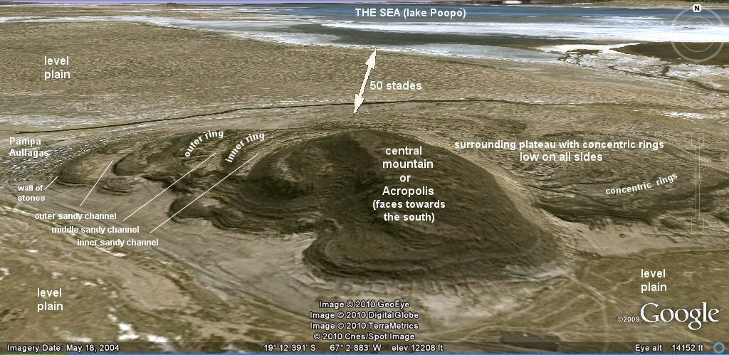
The Atlantis mountain at Pampa Aullagas, 50 stades from the sea.
Three sandy channels separated by rings of land as well as earthquake damage
can easily be seen on the west side of the volcano and on the south eastern side. The central cone or Acropolis
faces towards the south and is sheltered from the north by the northern rim of the volcano.
Pampa Aullagas, high resolution image looking from the west. Considerable damage appears
to have been done to the volcano with some parts sinking, others rising etc.
CLICK for more oblique photos
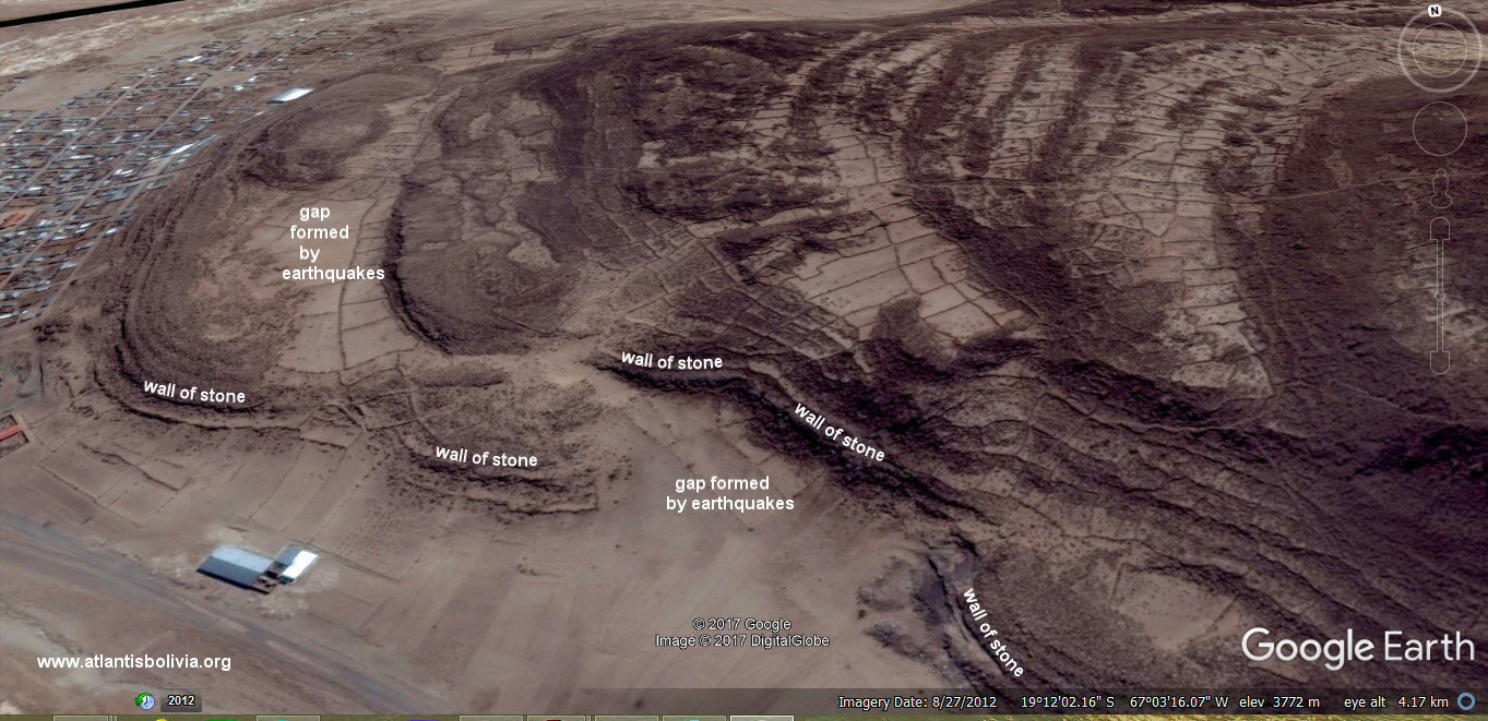
above, In this photo it can be seen that the western embankment on the extreme left has split
away and moved outwards from the original mountain. It would be useful to have geological
studies of the evolution and destruction of the mountain at Pampa Aullagas should any geologists like to volunteer
- it would appear that the mountain consists of two distinct events, the central volcanic cone which is solid rock and
continues right through to the original lava core beneath the earth, then at a later date lesser eruptions
continued and lava spilled from the volcano forming the low plateau of rock surrounding the cone and it may
be that this plateau was supported not on solid rock, but on the surrounding plain. Then when the plain which
is composed of millenia of soft windblown or lake deposited material sank and was consolidated due to the
earthquakes, the outer plateau of rock at Pampa Aullagas would similarly have broken away from the central
core and dropped in elevation. This can be seen in the above photo and also on the eastern side where a wide band of sand now surrounds the central cone and the concentric rings are twisted around so that today they end up pointing towards the central cone instead of being in that part concentric to it.
See additional photos on Pampa Aullagas page.
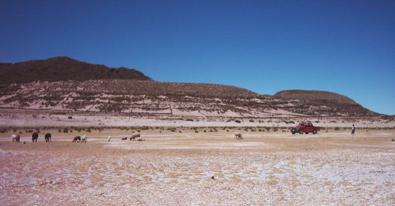
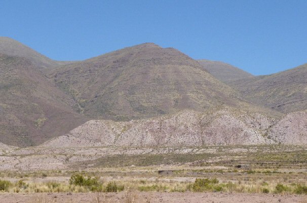
above, view of the site at Pampa Aullagas from the east showing as Plato called it "a mountain low on all sides".
This refers to the circular volcanic plateau which surrounds the central cone and which also contains the concentric
rings. The fine line marks the ancient water level which would have filled the sandy depessions leaving circular bands
of rock forming rings of land and water. The white sandy band on the central cone shows where this part of the cone has
fallen away due to earthquakes and it may be that the surrounding volcanic plateau was originally at this level.
The white sand on the sides of the outer plateau show where the level
plain has also dropped away from the original volcano.
The outermost circular channel is contained within an
embankment which continues around the outside of the volcano, seen in this view from the west.
Note how the plain has dropped away from the volcano,
there is a gap in the embankment giving access to the outer ringed channel
(over the ridge above and behind the jeep).
air photo showing remains of rings of land and entrance channel 3 plethra wide on northern side.
Critias 115e Bury translation
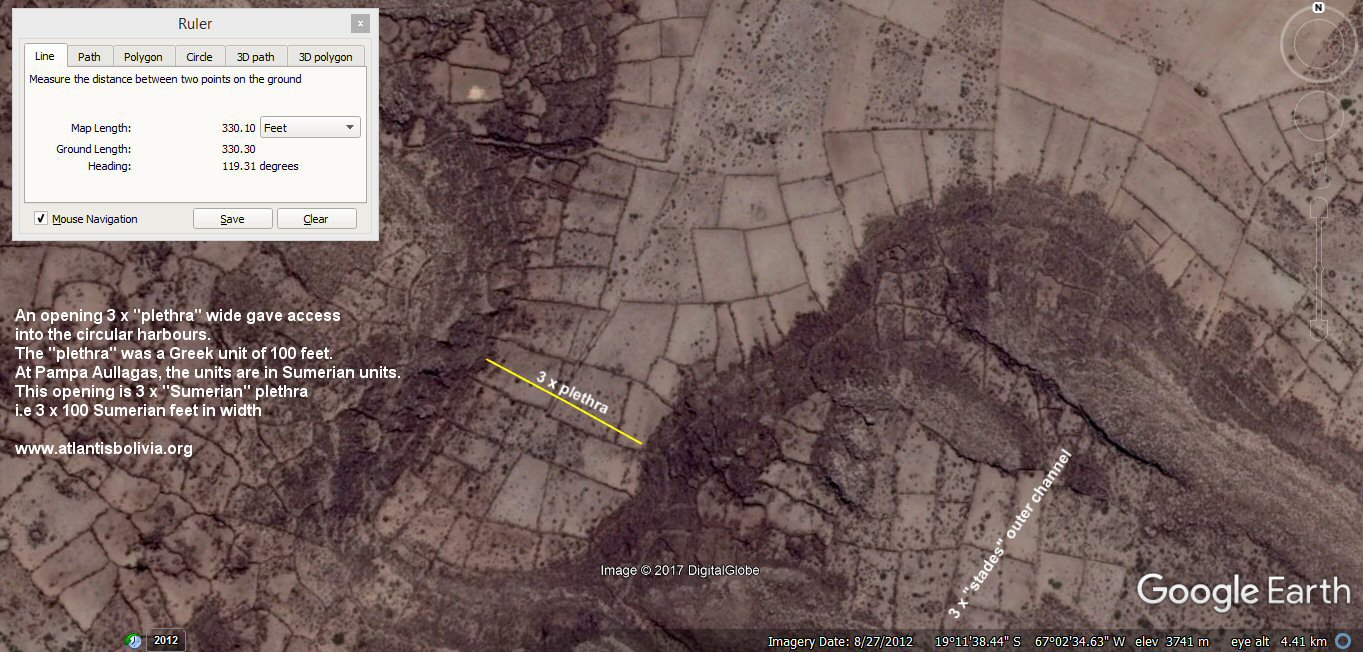
on the northern side there is a channel penetrating into the rings of land and sea. It measures 330
feet wide
=
3 x 110 feet which is 3 x 100 Sumerian feet, the "three plethra" described by Plato.
oblique view of remains of entrance channel today.
Ground view of remains of entrance channel cut through outer rim of volcano.

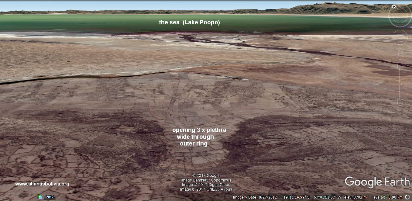
The outer canal was described by Plato as being 3 stades wide. The satellite measures the width of the outer
circular canal as 485 feet = 3 x "stades" of 100 cubits (3 x 165 feet).
the channel leading from the outer circle of water to the middle circle of water, view from the south.
Oblique view from the west showing the channel leading from the outer circle of water to the middle circle of water.
"Moreover, through the circles of land, [115e]
which divided those of sea, over against the bridges they opened
out a channel
leading from circle to circle, large enough to give
passage to a single vessel;"

the channel leading from the outer circle of water to the middle circle of water.
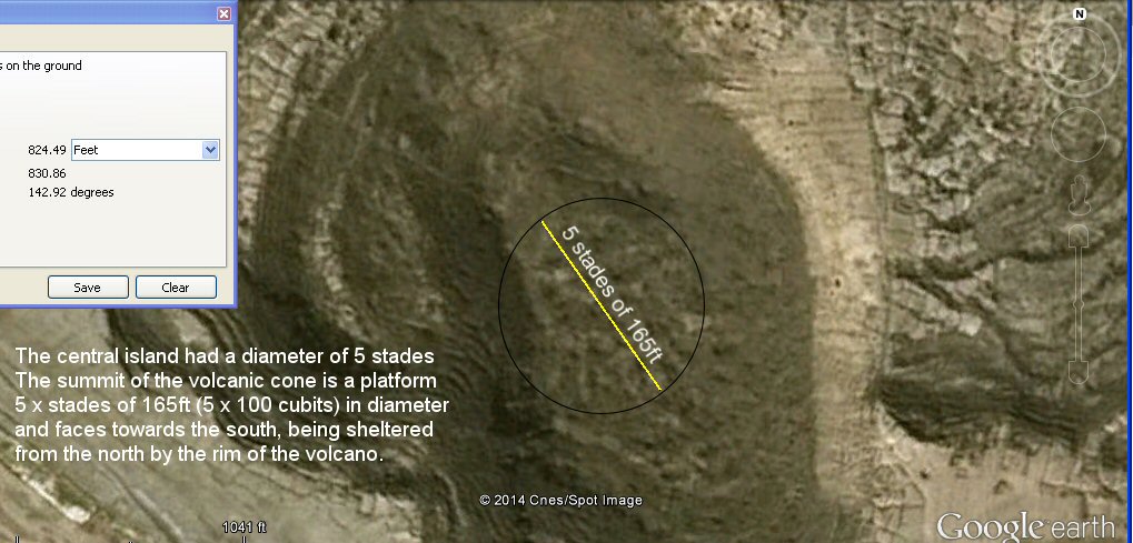
Above, The summit of the cone is 5 stades of 100 cubits (5 x 165ft) in diameter.
"And this island, [116a]
wherein stood the royal palace, was of five stades in diameter."
above, the central island faced towards the south, view from the north rim looking south.
"And this region, [118b] all along
the island, faced towards the South and was sheltered from the
Northern blasts."
above, "and was sheltered from the north" - as you can see, by the northern rim of the volcanic cone which forms the central island..
above, the outer and inner concentric sandy channels separated by ring of land with the village, level plain and the sea beyond.
In this view, the central water channel is blocked up with sand thrown up by the earthquakes.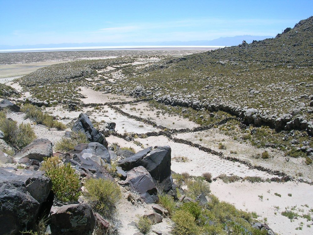
above, the outer canal on the west side, a gap between the embankments giving access to the outer ring
from the level plain can be seen on the extreme left of the picture.
above, inside the outer circular canal or channel on the west side.
above, middle canal on the north-west side, the continuation of the outer channel can also be seen beyond the ring of land.
above, inner ring on the west side.
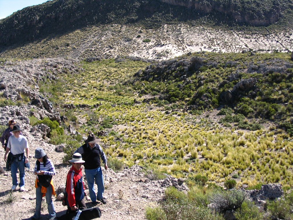
above, tourists check out this inner channel on the south-east side. Note how the channel
ends abruptly facing the mountain instead of enclosing it whilst the rocky face of the mountain
above has broken away and is now covered in sand..
above, middle canal on south east side
above, climbing into the middle channel on the south-east side.
Hot and cold springs were a feature of Atlantis

Above left, hot springs typical of the Altiplano. At Paria, to the north of the
lake they provide hot water for a swimming pool and at Pazna to the east of lake Poopo, they provide
hot water for a spa with individual baths.
Above right, cold water springs entertain tourists at Pampa Aullagas.
Plato: "The springs they made use of, one kind being of cold, another of warm water,
were of abundant volume....
and, moreover, they set reservoirs round about, some under the open sky, and others under cover to supply hot baths
in the winter"
The mines of Atlantis
Amongst the numerous features mentioned by Plato,
we should also mention the metals.
Amongst these were gold, silver, copper, tin and a mysterious alloy
called "orichalcum".
Plato: "The wealth they possessed was so great that the like will never easily be seen again."
The walls of the city were said to be plated in metals which to us were
rare and valuable, but to the original inhabitants were common and
plentiful.
The main motivation for the Spanish Conquest of the
continent was the abundance of precious metals to be found there.
The gold of Peru is already famous in the world, and
the silver from the mines in Potosi in Bolivia was a rich fountain of
wealth which drove forward the Spanish Empire. Next
to the mountain of silver in Potosi there is another mountain of tin,
which is also a rare metal not found in many places in the world.
In Atlantis, the kings bathed in baths fed by natural hot and cold springs. When the Conquistadors first went to interview the Inca ruler, Atahualpa, they found him "Atahualpa was in a small building close to some baths, the natural hot springs of Kónoj that still hiss and bubble out of the ground to this day. ... The Pleasure house had two towers rising from four chambers, with a courtyard in the middle. In this court, a pool had been made and two pipes of water, one hot and one cold entered it. The two pipes came from springs. ... beside one another. The Inca and his women used to bathe in the pool."
Following the capture of Atahualpa at Cajamarca, the plunder of Peru began. From the Inca's camp alone, came "eighty thousand pesos of gold, seven thousand marks of silver and fourteen emeralds. The gold and silver was in monstrous effigies, large and small dishes, pitchers, jugs, basins and large drinking vessles, and various other pieces. Atahualpa said that this all came from his dinner service." ... Atahualpa subsequently offered a ransome to the Spaniards for his freedom. He promised to fill a room measuring 22 feet long by 17 feet height, up to a line 8 feet high, with gold and golden objects and this was to be completed within the space of two months.
The treasure trains began to arrive frequently and shortly afterwards the melting down of the treasure and destruction of all the historic and artistic pieces began. "Indian smiths carried out the melting on nine forges ... On many days the smiths were melting 60,000 pesos - over 600 pounds of gold. Over eleven tons of gold objects were fed into the furnaces of Cajamarca, to produce 13,420 pounds of 22½-carat 'good gold'; the silver objects yielded 26,000 pounds of good silver. (The spoils were subsequently divided amongst the conquistadors, a horseman received some 90 pounds of gold and 180 of silver, and foot-soldiers received half this amount.) Franciso Pizarro took seven times the horeseman's quota and also the throne on which Atahualpa had travelled - it was 15-carat gold and weighted 183 pounds. The Spanish Crown was rewarded with one fifth of all the gold, silver , jewels etc.
After the initial melt down and distribution of the gold, further convoys of gold continued to arrive and following the death of Atahualpa at the hands of the Spanish, additional gold which had been on its way was secretly hidden.
Just as the walls of the temples in Atlantis were plated in gold, silver and orichalcum, the walls of the temples of the Incas were similarly plated in gold, silver and orichalcum (known locally as tumbaga). When the conquistadors ransacked the Temple of the Sun known as the Coricancha in Cusco - they found "These buildings were sheathed in gold, in large plates.... The Spaniards prised off seven hundred plates, which Xerez reported as averaging some 4½ pounds of gold each when melted down."
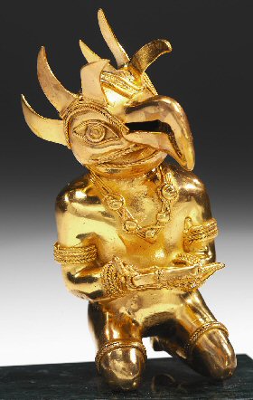
In Atlantis, we are told, they had "statues in gold of their ancestors".
When the Spaniards returned to complete the plunder of Cusco, "in one cave they found
twelve sentries of gold and silver, of the size and appearance of those of this country" ...
they also found ... golden effigies, golden statues, a garden of golden plants, altars made of gold,
golden images of the sun etc.
(source "The Conquest of the Incas", by John Hemming)
But the metal which puzzled people most of all, was
Plato's description of "orichalcum" since it was the second most
valuable metal then known, it could be polished and "sparkled like fire"
and there were mines of it throughout the island.
R.G. Bury considered it might have been "mountain
copper" but in fact a natural alloy of gold and copper matching Plato's
description exists in the Andes where it is called Tumbaga.
Not only that, but when the gold/copper alloy is heated then the object immersed in a special solution,
the copper disolves from the surface to leave an object with the appearance of pure gold. The object
can then be polished to consolidate the gold atoms on the surface and further enhance the sparkling, golden appearance.
The copper is dissolved from the surface to reveal a golden object
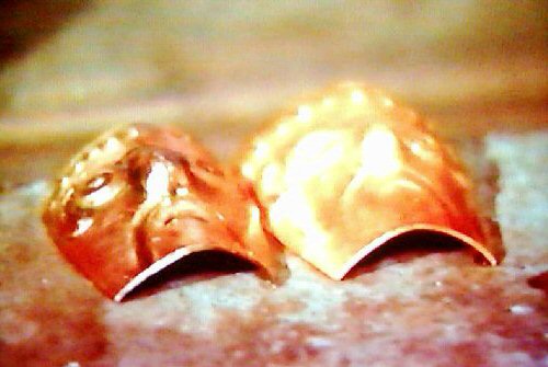
Above, an object of orichalcum (tumbaga) looking like copper on the left before treatment
and looking like gold
on the right after treatment.
Above, an object of orichalcum (tumbaga) -
easy to see why it would be the second most valuable metal after gold since it looks so much like gold itself!
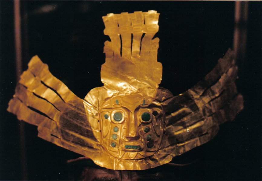
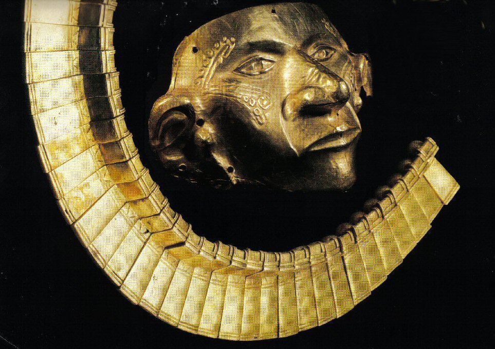
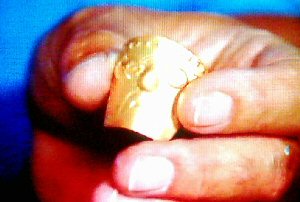
Above, (left) a gold mask from the precious metals museum, La Paz.
Above (right) a mask and collar of Orichalcum
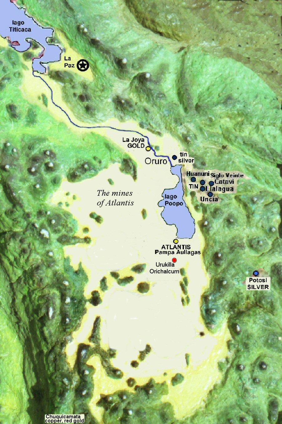
Location of the mines of the metals mentioned by Plato, all adjacent to Lake Poopo and the Atlantis site at Pampa Aullagas
Red, Black and White stones of Atlantis
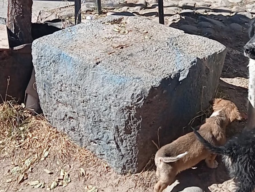
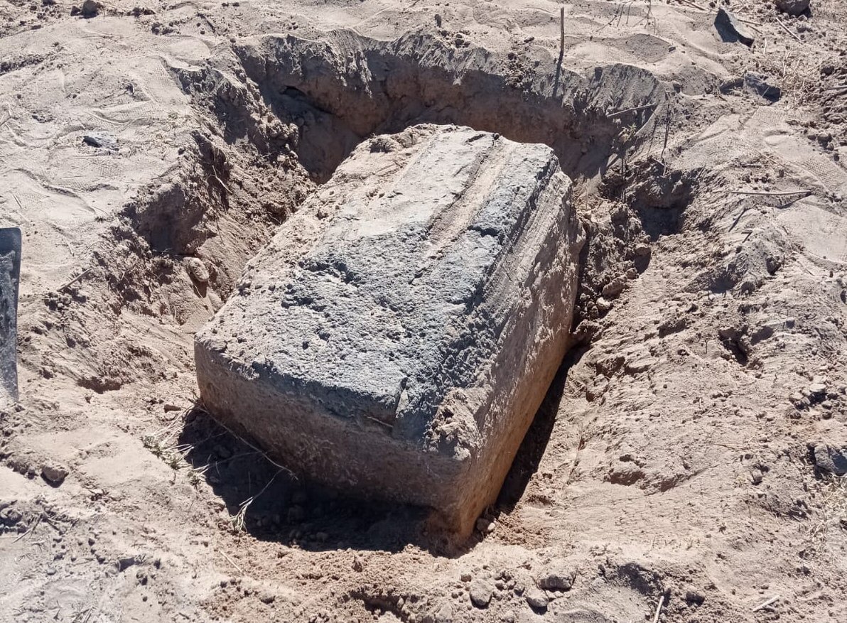
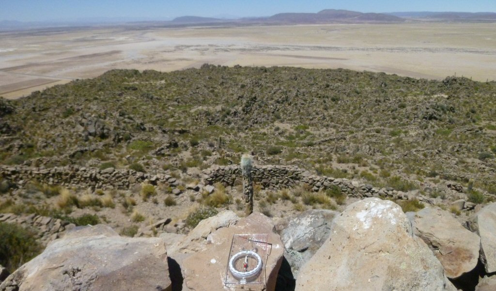
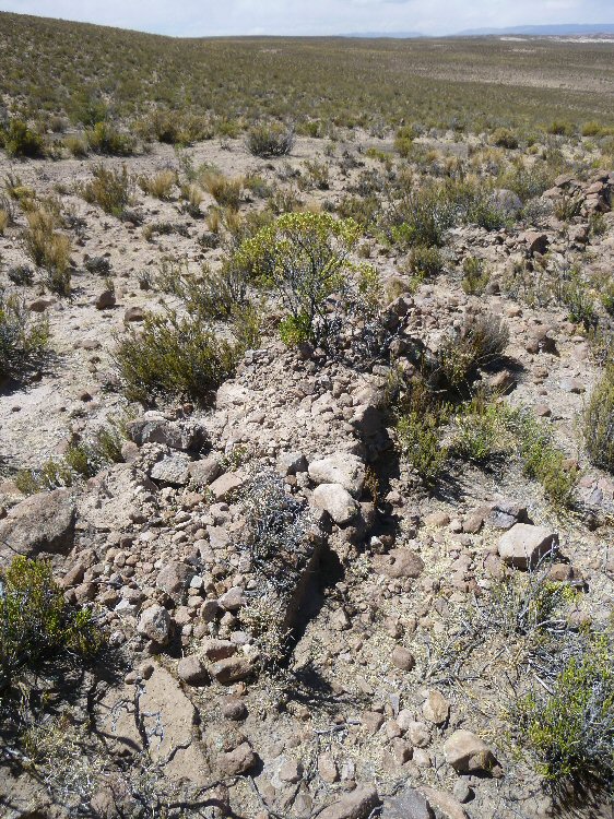
Before leaving the actual site itself, another important factor which may be easily demonstrated on this site is that Plato mentioned that the buildings were made of red, black and white stones, intermixed to give a pleasing appearance. All three colours of stone are to be found at Pampa Aullagas, some looking as if they are fragments from stones used in former buildings though no ancient buildings themselves remain.
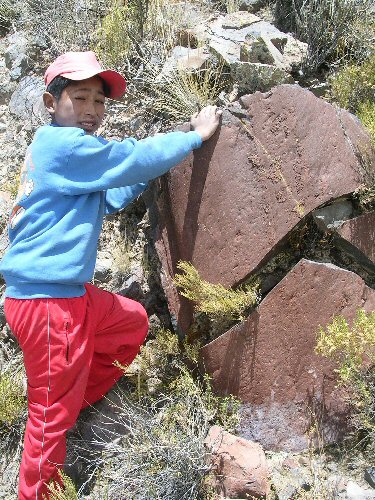
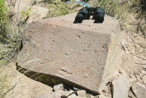
above, red and white stones at Pampa Aullagas, below, black stone at Pampa Aullagas

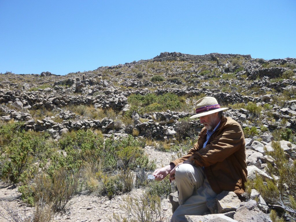
J.M. Allen with one of the stone blocks
covered in fossilised lake
sediments
at Pampa Aullagas
J.M. Allen with one of the stone blocks
found underneath the ground
at base of mountain at Pampa Aullagas
Earthquakes were a major factor in the destruction of Atlantis
Earthquakes destroyed the southern portion of the mountain at
Pampa Aullagas
This region of the Altiplano lies in a major earthquake zone and earthquakes are still a major problem for peoples in the area.
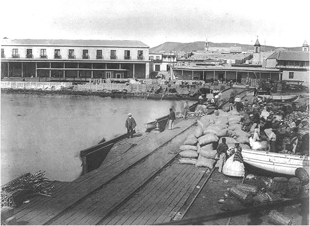
Above, left, the nearby port of Arica before 1868, view looking north
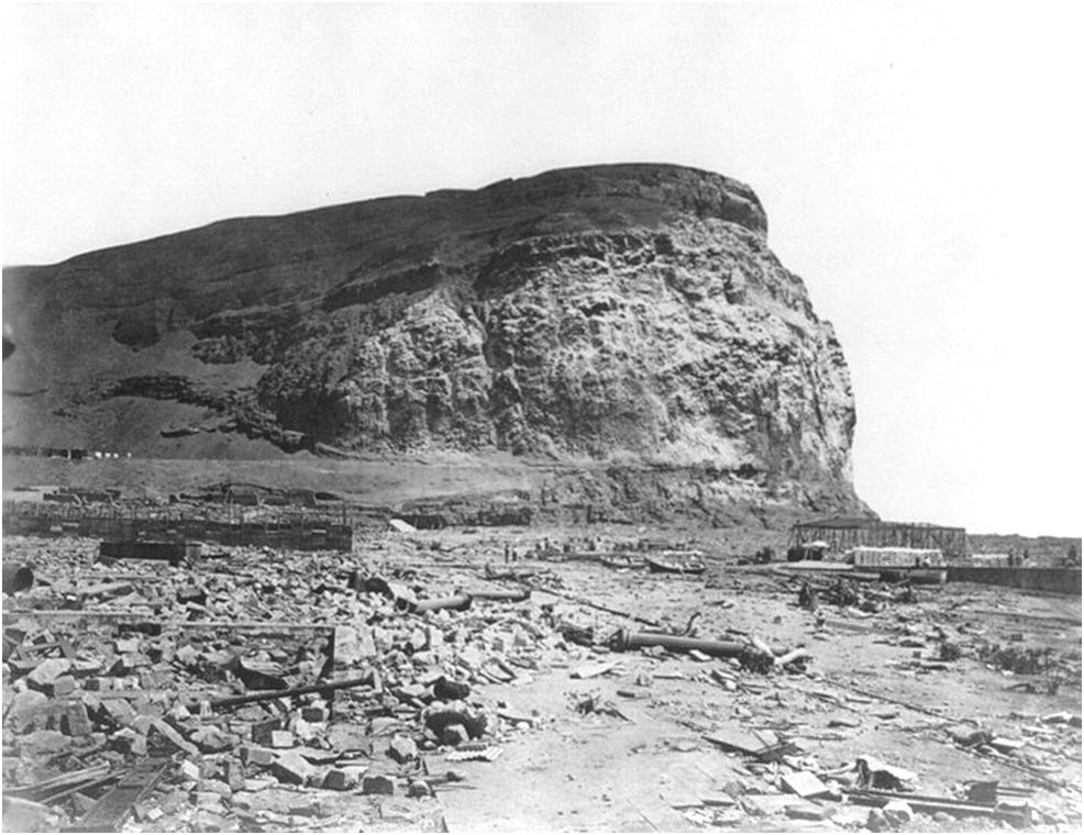
above right the port of Arica after the earthquake of 1868, view looking south toward El Morro.
After destruction by earthquakes, there may be nothing left at all of ancient cities unlike shown in contemporary
cinema where sunken cities lie more or less intact on the bottom of the sea!
Above, left, hills with terraces destroyed by earthquakes east of lake Poopo.
right, hill with ringed channels or terraces destroyed by earthquakes on the northeast side.

Above, it can easily be seen how the entire northeastern sector has been destroyed by earthquakes.
Above, left, ground view, the concentric rings are on the far side of the high hill in the centre.
Right, evidence of earthquake upheaval at the base of the mountain.
Above, higher resolution suggests the concentric rings were originally irrigation canals
but in other similar sites
only concentric terraces are seen.
It looks like at a later time,
people have re-occupied the area and built walls next to the remains of the channels or terraces.
CLICK for Ringed Hills page

Above, the latest high resolution image shows the concentric channels more clearly
and shows how later walls have been built alongside the original channels or terraces, it also
measures the remains of a concentric channel or terrace 19.5ft
wide.
Above, another ringed hill disrupted by
earthquakes at Norcala, west of Lake Poopo.
Above, close-up suggests these to be remains of concentric irrigation channels
in a site destroyed by
earthquakes west of Lake Poopo, but when visited on site only remains of three concentric walled terraces could be seen.
Above, remains of concentric retaining walls at the above site at Norcala.
Above, another ringed hill in the Oruro (Viacha) zone with remains of concentric walls.
Above, another hilltop with concentric rings, again they appear to be concentric
irrigation trenches typical of the Altiplano but need confirmation on site.
Above, many of these hilltops were surrounded by what turned out to be ringed concentric walled terraces.
Above, the concentric ringed and walled terraces possibly also used to retain water for irrigation
are associated with an ancient system of vertical terraces formed by long columns of stones cleared from the sites
on a vast scale which has been mistaken for "geoglyphs".

Above, one of the columns of stones mistaken for "geoglyphs". These long columns provided effective windbreaks sheltering
the cleared fields in a form of "vertical terracing" largely disused today as many of the sites now have no topsoil, only barren stony ground.
Above, condiderable destruction by earthquakes put an end to an ancient system of
cultivation with long artificial columns of stones resembling "geoglyphs"
accompanied by hilltops surrounded by concentric ringed terraces in this region of the Altiplano.
see geoglyphs agriculture page
Above, ground view of columns of stones cleared from the land and fissures amongst these ancient agricultural field systems.
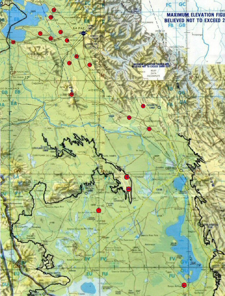
Above, map showing earthquaked sites seen on Google Earth (marked with red circles)
which seem to follow a fault line extending from the north of Tiwanaku right down to Pampa Aullagas.
Could this have been the "cataclysm" Plato described?
The “Sombrero uplift” – ground deformation detected in Altiplano–Puna volcanic province
"Bordering on the sea and extending through the center of the whole island there
was a plain, which is said to have been the fairest of all plains and highly fertile;" (113c Bury)
So here is a site that has all the factors that Plato
mentioned, firstly it is in the centre of the level rectangular plain at a
distance of 50 stades from the sea. It has the required red, black and white
stone. It has underground hot and cold springs. It is a route centre at the
southern end of the lake. And most important of all, it has been sunk by earthquakes and floods
just as Plato described.
To resume some of Plato's points then, the Altiplano is the only location
in the world which conforms to the geographic description of Plato's Atlantis,
suggesting that he did in fact indirectly receive a description of the "Atlantic Island" which
he then incorporated into his story about the ideal system of government,
adding a few details of his own and confusing everyone with
his distortion of the date and details of military exploits (see page 4).
But certain details are so unique to the Altiplano
that they could not have been "invented" by Plato and are certainly not found anywhere else, particularly for
example the five pairs of twin sons or the mysterious metal "orichalcum".
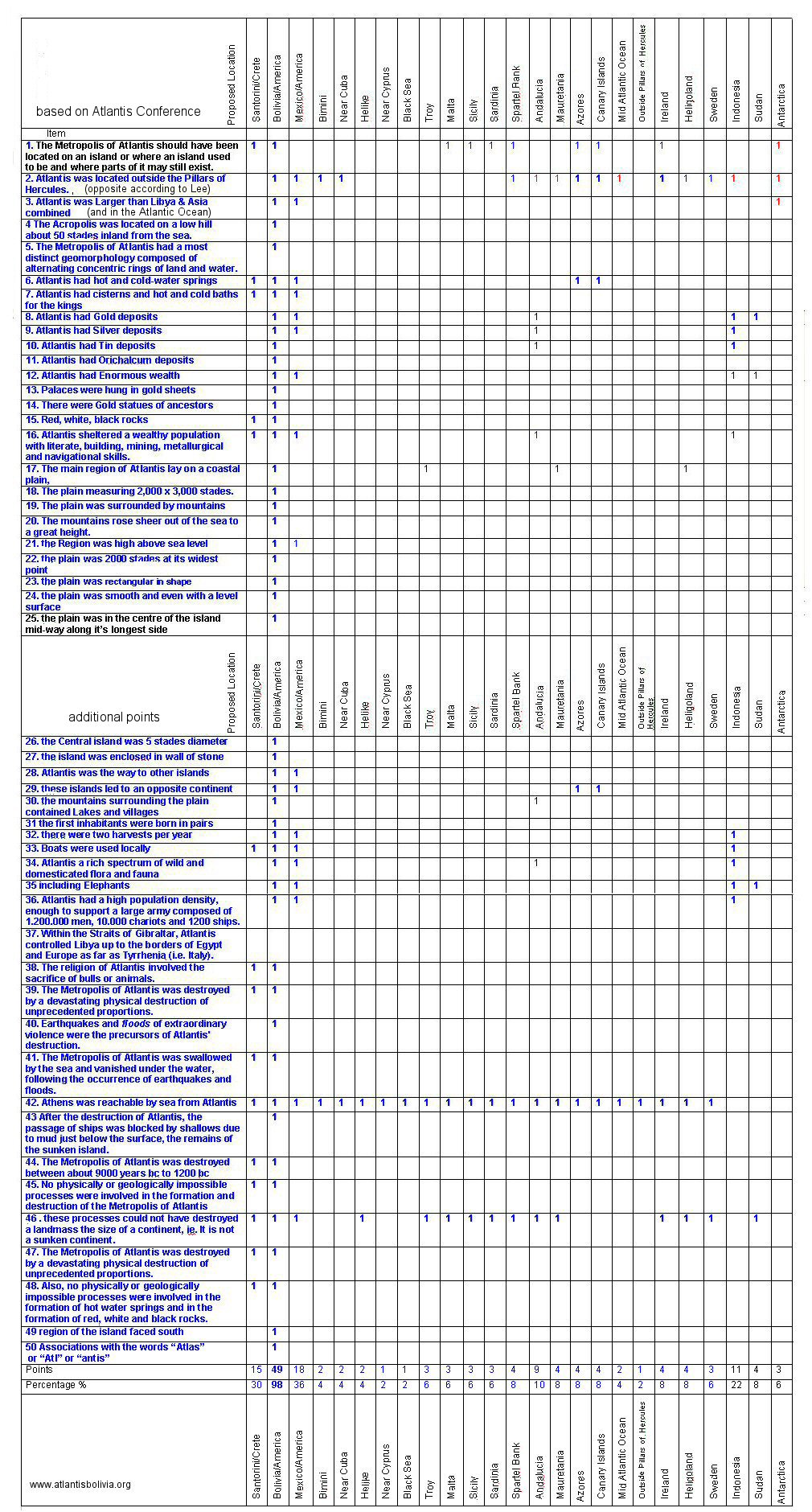
The Milos Atlantis conference compiled a list of 24 points they thought a site might have if it were
to be a candidate for Atlantis.
The only logical way forward with Plato's Atlantis is to examine his text point
by point and determine whether any proposed site has the actual characteristics Plato described.
Thus we can arrive at say 50
definitive points and any proposed site can be rated to see how they correspond.
Whereas some details such as animal sacrifice can be found anywhere in the world, other features are quite
unique such as the size large than Libya and Asia together, the rectangular plain midway along the longest side of the continent,
the central island surrounded by concentric rings of land, the presence of metals gold, silver, copper and tin in the same site and in sufficient quantities to plate temple walls
and fuse over the concentric rings surrounding the central Acropolis.
Thus we can see that using a basis of logic instead of prejudice, Bolivia and South America has a 98% correspondence to the geographic points
described by Plato, while popular sites such as Crete or Antarctic have little correspondence to the actual description.
continue to page 3 for Bolivian legend of Atlantis and discovery of "America"
"In a study published today, October 12, 2012 in Science, scientists used radar data from the ESA’s ERS and Envisat missions to study an unusual uplift near the Uturuncu volcano, which had been dormant for 270 000 years.
Authors of the study led by Yuri Fialko have detected ground deformation under way above a major subterranean magma body in the central Andes mountains. The deformation is attributed to a ballooning of a buoyant volume of molten rock at the top of the Altiplano–Puna magma body.
The Altiplano–Puna volcanic province is part of an active volcanic arc in South America’s central Andes. Extending through Peru, southwestern Bolivia, Chile and northwestern Argentina, it is home to a number of large calderas formed following catastrophic eruptions.
Beneath the surface of Altiplano–Puna, about 17–19 km deep, lies the largest known active magma body in Earth’s continental crust."
The plain which "extends through the centre of the whole island" begins at the northern
end of lake Titicaca and continues all the way south past lake Poopo to Uyuni. Satellite imagery
shows that all the way from around lake Titicaca down to Pampa Aullagas at the southern end of lake Poopo
was at one time highly cultivated
with a variety of agricultural systems
highly engineered to modify the landscape.
Later on in the story, Plato returns to a description of the plain, this time describing the region around
the capital city
"In the first place, then, according to the account, the whole region rose sheer out of the sea
to a great height, but the part about the city was all a smooth plain, enclosing it round about,
and being itself encircled by mountains which stretched as far as to the sea; and this plain had
a level surface and was as a whole rectangular in shape, being 3000 stades long on either side
and 2000 stades wide at its centre, reckoning upwards from the sea." (118a Bury)
This region also formerly possessed a much higher water level which not only enabled the canals, ponds
and artificial islands to function, but which provided a completely different habitat to that usually
preferred by Europeans, it would seem that unlike Europeans who prefer to drain land for agriculture,
in many regions where a suitable water level already existed the ancient Americans actually preferred
a marshy water covered area which they could adapt with artificial islands and lagoons.
Today large parts of the level rectangular part of the plain are covered with extensive salt salars, the result
of thousands of years of alternate flooding and drying, yet
the remains of the
Uru
people (famous for their floating reed islands)
still live
surrounded by canals on the edge of the Salar de Coipasa,
last
remnant of a people with a water based culture and whose name actually means "men of water".
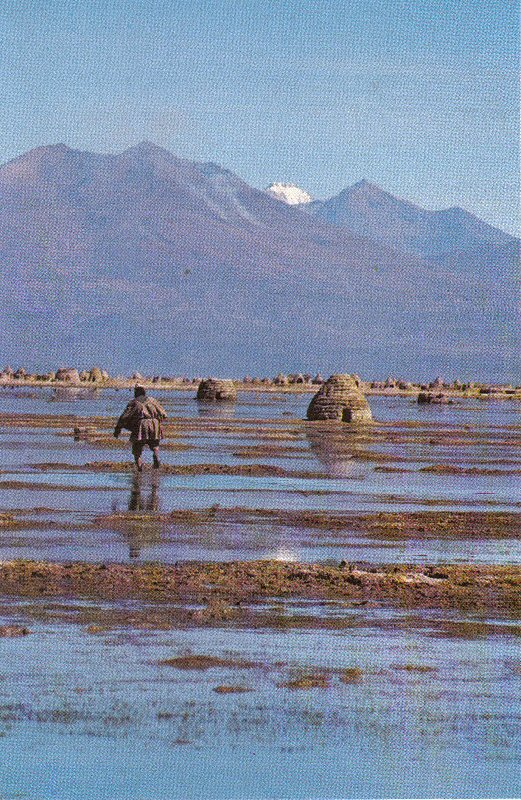
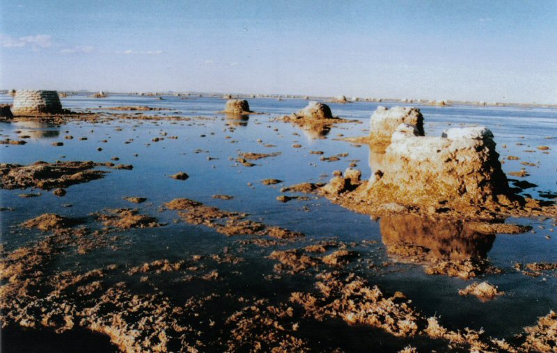
Above, the Uru Chipaya peoples lived in circular huts surrounded by the level plain seen here flooded in the wet season
.
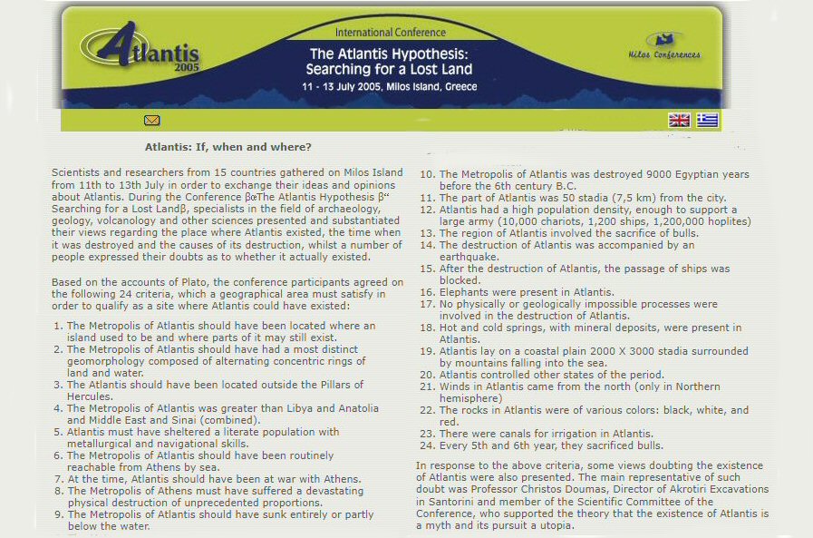
Above, in 2005 the Atlantis conference in Milos, Greece proposed a list of 24 points that a site ought to have to be considered as the location of Atlantis.