|
from the Timaeus: |
Interpretation and comments |
|
Then listen, Socrates, to a tale which, though strange, is certainly true
And what is this ancient famous action of the Athenians, which Critias
declared, on the authority of Solon, to be not a mere legend, but an actual fact?
And what other, Critias, can we find that will be better than this,
which is natural and suitable to the festival of the goddess, and has the
very great advantage of being a fact
and not a fiction? |
Plato says three times that the Atlantis story is a true story. He says
that they are going to use this story as the basis of a story which they
will use and build upon at the festival of Athena |
|
you must not be surprised if you should perhaps hear Hellenic names
given to foreigners Solon, who was intending to use the tale for his poem,
enquired into the meaning of the names, and found that the early Egyptians
in writing them down had translated them into their own language,
and he recovered the meaning of the several names and when copying them
out again translated them into our language |
Poseidon was the Greek god of the sea, known as Neptune in Rome and
Tunapa in Bolivia. Other words such as Trireme is the familiar Greek name
for a ship or warship. |
|
She founded your city a thousand years before ours, and afterwards she
founded ours, of which the
constitution is recorded in our sacred registers to be eight thousand
years old. |
According to the tale, Egypt was founded around 8,500BC and Athens in
9,500BC |
|
As touching your citizens of nine
thousand years ago, |
There is no record of civilisations in Egypt or Greece in 9,600BC, but
Plato uses the same date for the destruction of Atlantis as he does for
the founding of Greece and the wars between Atlantis, Greece and
Egypt. |
|
1 For these histories tell of a mighty
power which unprovoked made an expedition against the whole of Europe and
Asia, This power came forth
out of the Atlantic Ocean, Jowett
For it is related in our records how once upon a time your state stayed
the course of a mighty host, which, starting from a distant point in the Atlantic ocean, Bury
Our records tell how your city checked a great power which arrogantly
advanced from its base in the
Atlantic ocean Lee |
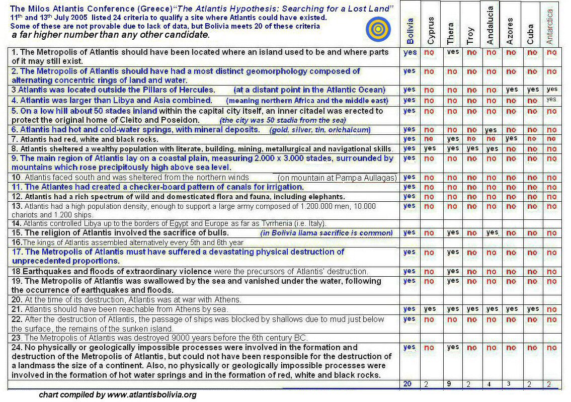
Atlantis was located in the Atlantic Ocean. It is pointless to try and
relocate Atlantis to within the Straits or move the Straits to inside the
Mediterranean, because the text clearly says Atlantis was a continent in
the Atlantic Ocean.

|
|
2 there was an island situated
in front of the
straits which are by you called the Pillars
of Heracles; Jowett
in front of the mouth which you Greeks
call, as you say, "the pillars of Heracles" Bury
There was an island
opposite the strait which you call (so you
say) the Pillars of Heracles, Lee |
The island of Atlantis was located in front of or opposite the Straits
of Gibraltar (Pillars of Hercules). South America is the "island" opposite
the Strait of Gibraltar.

|
|
3 the island was larger than Libya and Asia put
together, |
Atlantis was a continent as large as Libya (North Africa) and Asia
combined.
South America is an immense continent which is virtually an island
in its own right and easily comparible in size to Libya (North Africa) and Asia
combined whether considerd on its own or combined with its twin continent of North America.

|
|
4 and was
the way to other islands
|
Beyond South America there are islands in the Pacific |
|
5 and from these you might pass to the whole of the opposite
continent which surrounded the true ocean;
|
which lead to "the opposite continent" i.e to Asia, the true ocean
being the Atlantic and Pacific combined and which surrounds all of the
Earth

|
|
Now in this island of Atlantis there was a great and wonderful empire which had rule over the whole island and several
others, and over parts of the continent, furthermore, the men of Atlantis
had subjected the parts of Libya within the columns of Heracles as far as
Egypt, and of Europe as far as Tyrrhenia. This vast power, gathered into
one, endeavoured to subdue at a blow our country and yours and the whole
of the region within the straits |
This sounds like a description of the war by the "Sea Peoples" against
Egypt which took place around 1226BC and 1186BC. The "Sea Peoples" also
advanced by land, entering Egypt from Palestine and
Libya.

|
|
6 afterwards there occurred violent earthquakes and
floods; and the island of Atlantis in like
manner disappeared in the depths of the sea. Jowett
At a later time there occurred portentous earthquakes and floods, and one grievous day and night befell them, and the island of
Atlantis in like manner was swallowed up by the sea and vanished Bury
At a later time there were earthquakes and floods of
extraordinary violence, and in one single dreadful day and night the
island of Atlantis was swallowed up by the sea and vanished;
Lee |
Atlantis was destroyed by earthquakes and floods. The Altiplano has
periodically been subject to climatic change in the form of alternating
inland seas (lakes Minchin, Tauca, Coipasa) and dry periods. It is also
prone to earthquakes, evidence of which can be seen at Pampa Aullagas
where the volcano and the surrounding plain has been sunk by earthquakes.
It was only the capital island city of Atlantis which sank into the sea,
not the whole continent.
 Lake Tauca
 |
|
7 For which reason the sea in those
parts is impassable and impenetrable, because there is a shoal of mud in
the way; and this was caused by the subsidence of the island. Jowett
wherefore also the ocean at that spot has now become impassable and
unsearcheable, being blocked up by the shoal mud which the island threw up
as it settled down Bury
this is why the sea in that area is to this day impassable to
navigation, which is hindered by mud just below the surface, the remains
of the sunken island. Lee |
The inland sea of Lake Poopo formerly called Lake Aullagas is sometimes
entirely impassable to boats when it dries up in the dry season. Plato
implied that the island of Atlantis was swallowed up by the sea and
disappeared beneath the earth, but Sir Francis Bacon said Plato got it
wrong and the sea rose to cover the city.

|
|
from Critias: |
|
|
that nine thousand was the sum of
years which had
elapsed since the war |
Nine thousand years previously was given as the date for the founding
of Athens but is also given as the date for the war and end of
Atlantis. Clearly there is an error here, but if the 9,000 years were
taken as lunar months then it would be 1260BC which is the date of the
Trojan war and more or less the date of the founding of Athens (1400BC) by
Theseus. It is unlikely that Atlantis could have existed on the Altiplano
in 9,600BC since at that time it had already been under the waters of Lake
Tauca for some time. When Lake Tauca dried up, there were periods of
alternating droughts and floods and Atlantis could have begun in any of
these periods continuing perhaps up to the date of around 1260BC
(substituting months for years) which Plato gave for the war and Atlantis'
subsequent destruction. |
|
8 Looking towards the sea, but in the
centre of the whole island, there was a plain Jowett
Bordering on the sea and extending through the centre of the whole
island there was a plain Bury
At the centre of the island (ie midway along its greatest length,) near the sea, was a plain Lee |
This plain is the Altiplano, which not only is on the centre of the
whole continent, but as Lee says, it is midway along its longest side.

|
|
9 Near the plain again, and also in the
centre of the island at a distance of about fifty stadia, there was a mountain not very high on any
side. Jowett
and, moreover, near the plain, over against its centre, at a distance
of about fifty stades, there
stood a mountain that was low on all sides.
Bury
and near the middle of this plain about fifty stades inland
a hill of no great
size. Lee |
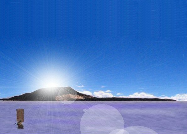
At this location we find the volcanic mountain of Pampa Aullagas, a
central cone on top of a low plateau fifty stades or five miles from the
inland sea of Lake Poopo
 |
|
10 Theron dwelt one of the natives originally
sprung from the earth… and Poseidon, being smitten with desire for her,
wedded her. Bury |
This corresponds to the tale of Tunapa, God of the lakes and rivers who
married Azanques, god of a hill opposite Pampa Aullagas. |
|
11 Poseidon ...breaking the ground,
enclosed the hill all round, making alternate zones of sea and land larger
and smaller, encircling one another; so that no man could get to the
island, for ships and voyages were not as yet Jowett
Poseidon...to make the hill impregnable he broke it off all round
about; and he made circular belts of sea and land enclosing one another
alternately, some greater, some smaller, , so as to be impassable for man;
for at that time neither ships nor sailing were yet in existence. Bury
Poseidon...fortified the hill by enclosing it with concentric rings of
sea and land, making the place impassable for man (for there were still no
ships or sailing in those days) Lee |
In the Bolivian story, Tunapa ran away from Azanaques and laid down in
Pampa Aullagas, thus creating the ringed formation there, described as
zones, belts or rings. Pampa Aullagas
has remains of these zones of land and formerly sea when the lake level
was higher.
 |
|
12 there were two of land and three of
water, which he turned as with a lathe, each having its circumference
equidistant every way from the centre, Jowett
two being of land and three of sea, which he carved as it were out of
the midst of the island; and these belts were at even distances on all
sides Bury
There were two rings of land and three of sea, like cartwheels, with
the island at their centre and equidistant from each other,
Lee |
At Pampa Aullagas there are two rings of land and three concentric canal-like depressions.


|
|
13 beginning from the sea they bored a canal of
three hundred feet in width and one hundred feet in depth and fifty stadia
in length, which they carried through to the outermost zone, making a
passage from the sea up to this, which became a harbour, and leaving an
opening sufficient to enable the largest vessels to find ingress.
|
At Pampa Aullagas there is to this day a canal or river which leads
from the sea to the outer ring at the site and continues on to the level
plain.
 |
|
14 Moreover, they divided the zones of land
which parted the zones of sea, leaving room for a single trireme to pass
out of one zone into another
they covered over the channels so as to leave a way underneath for the
ships; for the banks were raised considerably above the water.
|
The outer ring at Pampa Aullagas has a gap where ships could have
sailed through. |
|
15 Now the largest of the zones into which a
passage was cut from the sea was three stadia in breadth, and the zone of
land which came next of equal breadth; but the next two zones, the one of
water, the other of land, were two stadia, and the one which surrounded
the central island was a stadium only in width. |
The stades used to describe the channels at Pampa Aullagas are units of 165ft which is 100 "Sumerian" cubits.

|
|
16 The island in which the palace was situated
had a diameter of five stadia |
The central island or cone at Pampa Aullagas is five stades of 165ft wide on its summit.

|
|
17 The island and the circles they encompassed
with a wall of stone. Bury |
The site at Pampa Aullagas including the outer ring is encompassed in a
wall of stone.
 |
|
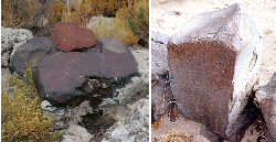
18 some being white, some black and some red.
|
Red, white and black stones are found at Pampa Aullagas.


|
|
19 Some of their buildings were simple, but in
others they put together different
stones, varying the colour to please the eye, and
to be a natural source of delight.
|
At nearby Quillacas, the local church is built of red, black and white
stones varied to give a pleasing appearance.

|
|
20 In the first place they dug out of
the earth whatever was to be found there, mineral as well as metal, and
that which is only a name and was something more than a name then,
orichalc, was dug out of the earth in many parts of the island, and except
gold was the most precious of metals Jowett
Metals to begin with, both the hard kind and the fusible kind, which
are extracted by mining, and also that kind which is now known only by
name but was more then a name then, there being mines of it in many parts
of the island, - I mean "orichalcum" which was the most precious of the
metals then known, except gold.
i.e. "mountain copper", a "sparkling" metal hard to
identify. Bury
It had mineral resources from which were mined both solid materials and
metals, including one metal which survives today only in name, but was
then mined in quantities in a number of locations in the island, orichalc,
in those days the most valuable metal except gold. Lee
"a completely unknown and imaginery
metal" Lee |
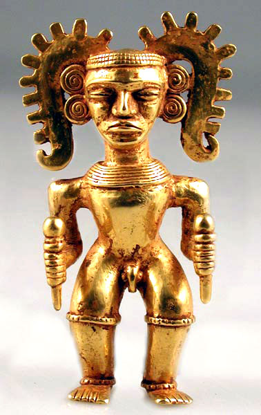
Orichalcum is considered by Sir Desmond Lee to be a
"a completely unknown and imaginery
metal" but such a natural alloy
exists only in the Andes where it is called Tumbaga. It can be polished
and the copper surface dissolved out to resemble pure gold.
 Orichalcum Orichalcum |
|
21 The entire circuit of the wall, which
went round the outermost zone, they covered with a coating of brass, and
the circuit of the next wall they coated with tin, and the third, which
encompassed the citadel, flashed with the red light of orichalcum. Jowett
And they covered with brass, as though with a plaster, all the
circumference of the wall which surrounded the outermost circle; and that
of the inner one they coated with tin; and that which encompassed the
acropolis itself with orichalcum which sparkled like fire
Bury
And they covered the whole circuit of the outermost wall with a veneer
of bronze, they fused tin over the inner wall and orichalc gleaming like fire over the wall of the acropolis itself
Lee |
Brass, tin and orichalcum according to Jowett and Bury.
Bronze, tin and orichalcum according to Lee.
Brass is an alloy of copper and zinc.
Bronze is an alloy of copper and tin.
Orichalcum is an alloy of gold and copper.
All these metals and alloys are plentiful in the region around Lake
Poopo, Bolivia including a mountain of silver, a mountain of gold and mountains chock full of tin near Oruro

|
|
22 All the outside of the temple, with the
exception of the pinnacles, they
covered with silver, |
nearby Potosi was a mountain of solid silver


|
|
23 and the pinnacles with gold |
gold was abundant in pre-Inca times. Nearby La Joya has the largest gold mine in modern Bolivia.

|
|
In the interior of the temple the roof was of ivory, curiously wrought
everywhere with gold and silver and
orichalcum Jowett
(ivory in appearance, variegated with gold and silver and
orichalcum Bury) |
all these metals exist all around the plain and Lake
Poopo, Oruro is the centre of the mining industry.

|
|
and all the other parts, the walls and pillars
and floor, they coated with
orichalcum . |
the naturally occurring alloy of gold and copper, it was
customary in Inca times to cover the walls of building in sheets of gold or silver. |
|
24 In the temple they placed statues of gold: And
around the temple on the outside were placed statues of gold of all the descendants of the ten
kings and of their wives |
The custom of having golden statues of their ancestors continued into
the time of the Incas

|
|
25 they had such an amount of wealth as was never before possessed by
kings and potentates, and is not likely ever to be again
|
The land was so rich in gold it
motivated the Spanish to it's conquest.
Following
the capture of Atahualpa at Cajamarca, the plunder of Peru began. From
the Inca's camp alone, came "eighty thousand pesos of gold, seven
thousand marks of silver and fourteen emeralds. The gold and silver was
in monstrous effigies, large and small dishes, pitchers, jugs, basins
and large drinking vessles, and various other pieces. Atahualpa said
that this all came from his dinner service." ... Atahualpa subsequently
offered a ransome to the Spaniards for his freedom. He promised to fill
a room measuring 22 feet long by 17 feet height, up to a line 8 feet
high, with gold and golden objects and this was to be completed within
the space of two months.
The treasure trains began to arrive frequently and shortly
afterwards the melting down of the treasure and destruction of all the
historic and artistic pieces began. "Indian smiths carried out the
melting on nine forges ... On many days the smiths were melting 60,000
pesos - over 600 pounds of gold. Over eleven tons of gold objects were
fed into the furnaces of Cajamarca, to produce 13,420 pounds of
22½-carat 'good gold'; the silver objects yielded 26,000 pounds of good
silver. (The spoils were subsequently divided amongst the
conquistadors, a horseman received some 90 pounds of gold and 180 of
silver, and foot-soldiers received half this amount.) Franciso Pizarro
took seven times the horeseman's quota and also the throne on which
Atahualpa had travelled - it was 15-carat gold and weighted 183 pounds.
The Spanish Crown was rewarded with one fifth of all the gold, silver ,
jewels etc.

|
|
|
|
|
26 He himself, being a god, found no difficulty
in making special arrangements for the centre island, bringing up
two springs of water from beneath
the earth, one of warm water and the other of cold |
Hot and cold springs exist on the Altiplano and can be seen at Pazna.
Underground pools also exist at Pampa Aullagas.
 hot spring hot spring
 cold spring cold spring
|
|
27 and they were wonderfully adapted for use by
reason of the pleasantness and excellence of their waters. |
On the Island of the Sun in Lake Titicaca can be seen Inca springs with
three different types of water according to their properties.
 |
|
28 also they made cisterns, some open to the heavens, others roofed over, to
be used in winter as warm baths |
At Pazna on the other side of Lake Poopo can be seen thermal baths and
a large stone bath open to the elements. |
|
29 The entire area was densely crowded with
habitations; and the canal and the
largest of the harbours were full of vessels and merchants coming from all
parts, who, from their numbers, kept up a
multitudinous sound of human voices, and din and clatter of all sorts
night and day. |
From Pampa Aullagas, one could travel by boat to the far north-west
corner of the plain or even as far away as to the northern end of Lake
Titicaca, a distance of some 300 miles. The Uru culture was very much a
water borne culture thriving along the aquatic axis of the Altiplano.
|
|
Because of their headship, they had a large
supply of imports from abroad |
It is a very large continent and "imports from abroad" could simply
mean from other parts of the continent. However, in the museum at Oruro
may be seen an amphora similar to those from the Eastern Mediterranean and
the Fuente Magna dish found near Lake Titicaca with cuneiform writing also
suggests a contact with ancient Sumeria.
See artefacts

 |
|
I will now describe the plain, as it was fashioned by nature and by the
labours of many generations of kings through long ages. |
|
|
30 The whole country was said by him to
be very lofty and precipitous on the side of the sea, but the country
immediately about and surrounding the city was a level plain, itself
surrounded by mountains which descended towards the sea; Jowett
The whole region rose sheer out of the sea to a great height, but the
part about the city was all a smooth plain, enclosing it round about, and
being itself encircled by mountains which stretched as far as to the sea;
Bury
To begin with the region as a whole was said to be high above the level
of the sea, from which it rose precipitously; the city was surrounded by a
uniformly flat plain, which was in turn enclosed by mountains which came
right down to the sea. Lee |
Note Jowett's translation…"precipitious on the side of the sea" The Altiplano is enclosed by mountains which just like the
description, rise sheer out of the sea to a great height on the Western
side of the plain i.e. on the side of the Pacific Ocean. The whole region,
as Plato says, is high above the level of the (Ocean) sea and the
mountains enclose it round about.

|
|
31 the plain was smooth and even
Jowett
and this plain had a level surface Bury
a uniformly flat plain Lee |
The Altiplano is smooth and level, the largest level plain in the
world.
 |
|
32 and of an oblong shape, It was for
the most part rectangular and oblong, Jowett
and was as a whole rectangular in shape, This plain was rectangular in
shape, It was originally a quadrangle, rectilinear for the most part, and
elongated; Bury
It was naturally a long, regular rectangle; Lee |
The Altiplano near Lake Poopo is indeed rectangular in shape and
elongated, or as Lee says, a long, narrow rectangle.
 |
|
33 extending in one direction three
thousand stadia, but across the centre inland it was two thousand stadia
Jowett
being 3000 stades long on either side and 2000 stades wide at its
centre, reckoning upwards from the sea. Bury
measuring three thousand stades in length and at its mid-point two
thousand stades in breadth from the coast. Lee |
The Altiplano near lake Poopo is in the proportion of 3,000 by
2,000 wide, the unit here being a half-furlong i.e. 330ft instead of the
Greek 600ft stade, so it measures across the centre from the sea 2,000 and lengthwise 3,000 half-furlongs.

|
|
34 and what it lacked of this shape they
made right by means of a trench dug round about it. Now, as regards the
depth of this trench and its breadth and length, it seems incredible that
it should be so large as the account states, considering that it was made
by hand, and in addition to all the other operations, but nonetheless we
must report what we heard.: It was dug out to the depth of a plethrum and
to a uniform breadth of a stade, and since it was dug round the whole
plain its consequent length was 10,000 stades. |
In the desert north-west of Lake Poopo there is a feature resembling a
giant canal of the dimensions Plato has given. It joins pools of natural
underground springs and is used by the locals to pasture their flocks. The
elevations of the rectangular Altiplano are such that a canal could be dug
around its perimeter in the fashion Plato described.
 |
|
The plain was for the most
part rectangular and oblong,
and where falling out of the straight line followed the circular ditch.
Jowett
It (the canal) made a complete circuit of the plain, running round to
the city from both directions, and there discharging into the sea Lee
and (the canal) winding round the plain Donnelly |
It is the plain which is rectangular and measures 3,000 x 2,000
"stades", or half-furlongs, sometimes the canal system is shown in a chequerboard pattern
but other translations say it "wound its way around the plain" implying it
followed natural contours and avoided obstacles such as volcanic
outcrops.

|
|
35 The depth, and width, and length of this
ditch were incredible, and gave the impression that a work of such extent,
in addition to so many others, could never have been artificial.
Nevertheless I must say what I was told. It was excavated to the depth of
a hundred, feet, and to a uniform breadth of a stade. |
The section visited on site was so large that the local archaeologist
did not believe that it had been made by hand
however a local geologist studying air photos of the feature asserted it
was indeed artificial.

|
|
36 It received the streams which came
down from the mountains and after circling round the plain, and coming
towards the city on this side and on that, it discharged them thereabouts
into the sea. |
There are streams which come down from the mountains surrounding the
plain and a perimeter canal could discharge them into Lake Poopo.
|
|
37 And on the inland side of the city
channels were cut in straight lines, of about 100 feet in width, across
the plain, and these discharged themselves into the trench on the seaward
side, the distance between each being 100 stades. |
Canals in parallel lines are a feature of the zone south of Oruro

|
|
38 It was in this way that they conveyed to the
city the timber from the mountains and transported also on boats the
seasons' products, by cutting transverse passages from one channel to the
next and also to the city. |
There were formerly trees around the Altiplano, much of the original
vegetation was destroyed by the Spaniards and the animals they brought
with them. The Uru peoples still use reed boats for transportation today
and the tradition of building reed boats is kept alive by local boatbuilders.
 see The Urus see The Urus
|
|
39 The surrounding mountains were celebrated for their number and
size and beauty, far beyond any which still exist,
having in them also many wealthy villages of country folk, and rivers, and lakes, and meadows
supplying food enough for every animal, wild or tame, and much wood of various sorts, abundant for each and every
kind of work. |
The surrounding mountains are high volcanic peaks such as Sajama
21,464ft, Ilampu 21067ft, Illimani 21005ft and there are indeed many
villages, meadows, rivers, lakes etc.
 |
|
40 Twice in the year they gathered the fruits
of the earth - in winter having the benefit of the rains of heaven, and in
summer the water which the land supplied by introducing streams from the
canals |
Where raised fields surrounded by artificial canals have been restored near Lake Titicaca they have
been able to harvest two crops per year and would have been able to
sustain a vastly greater population than today. The water table was a
delicately balanced system and in some periods would flow from Lake
Titicaca to the south whereas at other times it could flow northwards.

 They even have concentric
sukka kollus
similar to the Atlantis design. They even have concentric
sukka kollus
similar to the Atlantis design.
|
|
41 This part of the island looked towards the
south, and was sheltered from the north |
This refers to the summit of the central cone at Pampa Aullagas which faces south and
is sheltered from the north by the volcanic rim on the northern side.

|
|
|
|
|
42 He also begat and brought up five pairs of
twin male children |
The
whole country was divided into ten kingdoms, they were therefore twin
kingdoms. The Aymara kingdoms around Lake Poopo were similarly divided
into twin kingdoms and according to Huaman Poma, the first inhabitants
were also born in pairs, not only that but Viracocha adopted five pairs
of twin sons and the first Incas were also said to have been four pairs
of brothers and sisters. Pairs or twins are very prevalent in Andean
sculpture and pottery.

|
|
43 Moreover, there were a great number of
elephants in the island |
Remains of Mastodons which are a species of elephant may be seen in the museum in Tarija to the south
of the plain.

|
|
44 there was provision for all other sorts of
animals, both for those which live in lakes and marshes and rivers, and
also for those which live in mountains and on plains, |
The country is full of lakes, marshes and rivers. |
|
45 Also whatever fragrant things there now are
in the earth, whether roots, or herbage, or woods, or essences which
distil from fruit and flower, grew and thrived in that land; |
it also grows every conceivable product in abundance

|
|
46 And of the inhabitants of the mountains and
of the rest of the country there was also a vast multitude |
Huaman Poma recorded that there was a vast population before the time
of the Incas and that the watercourses, reservoirs etc could not easily be
repeated. |
|
47 For many generations, as long as the divine
nature lasted in them, they were obedient to the laws, for they possessed
true and in every way great spirits, uniting gentleness with wisdom in the
various chances of life, and in their intercourse with one another.
They despised everything but virtue, caring little for their present
state of life, and thinking lightly of the possession of gold and other
property, which seemed only a burden to them;
neither were they intoxicated by luxury; nor did wealth deprive them of
their self-control;
but they were sober, and saw clearly that all these goods are increased
by virtue and friendship with one another,
whereas by too great regard and respect for them, they are lost and
friendship with them.
but when the divine portion began to fade away, and became diluted too
often and too much with the mortal admixture, and the human nature got the
upper hand, they then, being unable to bear their fortune, behaved
unseemly, and to him who had an eye to see grew visibly debased, for they
were losing the fairest of their precious gifts;
but to those who had no eye to see the true happiness, they appeared
glorious and blessed at the very time when they were full of avarice and
unrighteous power.
Zeus, the god of gods, who rules according to law, and is able to see
into such things, perceiving that an honourable race was in a woeful
plight, and wanting to inflict punishment on them, that they might be
chastened and improve, collected all the gods into their most holy
habitation, which, being placed in the centre of the world, beholds all
created things. And when he had called them together, he spake as
follows... |
According to the Bolivian legend, the god Tunapa walked amongst the
people and tried to persuade them from their bad habits but was cast
adrift in a boat and eventually drowned in the waters of Pampa Aullagas
when the city was also destroyed by earthquakes and floods sent as a
punishment by the gods.


|
|
48 The name "Atlantis."

|
Atlantis sometimes known as Atlanticus or the Atlantic Island according to Plato was derived from the name of the first king, Atlas.
In mythology, Atlas was the god who held up the heavens and knew all about astronomy. The Andes
mountains could easily be considered as the "pillars" which hold up the sky and the Altiplano
is known locally as the place where Heaven meets Earth.
The Tiwanaku calendar also shows an advanced
knowledge of astronomy with both a solar calendar based on 20 months and a lunar calendar based on
40 sidereal lunar months. The names of Greek gods are thought to have been borrowed from near eastern gods,
yet "atl" is a typical Mexican or Aztec prefix.
|
|
49 "Atl" means "water" in Aztec Nahuatl.
In the wet season large parts of Amazonia
and the region known as the Beni in what
is now Bolivia are under
water as are parts of the Altiplano which also floods rapidly.
|
"Uma" is the Aymara word for water and Umasuyo the Aymara name for the
eastern half of the Andes - the kingdom of water.
The Altiplano itself was also a water kingdom with it's inland seas of
Lakes Titicaca and Poopo connected by the River
Desaguadero.

|
|
50 the name "Atlantis" = atl + antis.
"Antis" means "copper" in Quechua of the Incas. It is also the origin
of the "Andes" mountains making Atlantis the perfect name for the
continent we today call South America. |
The Inca name for their country was "Tahuantinsuyo" meaning "Land of the Four Quarters" and
one quarter of their empire was "Antisuyo" - kingdom of
the Antis Indians.
 Antis Indians Antis Indians

|