|
1. The Beginning of Studies on Kalasasaya
|
|
Since
the most important part of this work is that which has to do with the
great Temple of the Sun,
Kalasasaya, and the applied science possessed by American man,
we believe it fitting to review the laborious preparatory stages of
these studies which in all their ramifications, lasted more than a third
of a century and the quintessence of which is found in the present
chapter of the second volume of
TIHUANACU, THE CRADLE OF AMERICAN MAN. We shall first present a special bibliographic analysis related to the material.
We do not propose to mention here what
chroniclers and travelers have said on the subject. Neither do we wish
to scrutinize the works which modern laymen have devoted to the subject.
Rather, we wish only to refer to the works of authorized persons which,
not having lost their timeliness, have an important relation to that
supreme monument and the science which American man left us with it.
With respect to the works of chroniclers and travelers, as well as those
of dilettantes, we have set aside a bibliographical section at the end
of the last volume, accompanied with brief comments.
It was in the year 1904 that we began our work directed toward the discovery of the secrets held by
Kalasasaya and the Sun Door, its principal stone piece.
In an elemental manner, from the point of view of the engineer, we first
drew a map of the ruins and took detailed photographs of the monuments
on large plates. This course was followed in view of the fact that a few
years before there had begun, in systematic form, the destruction of
the magnificent ruins of
Tihuanacu; a destruction carried out both by the builders of
the Guaqui-La Paz railroad and the Indian contingent of the modern
village of Tihuanacu who used the ruins as a quarry for commercial
exploitation.
In view of this fact, and in order to
avoid their irreparable loss to Americanistic science and future
civilization and culture, the author proposed to save what still
remained. He struggled tenaciously along
Don Manuel Vicente Ballivián, President of the Geographic
Society of La Paz, and succeeded in having the Congress pass laws for
the protection of the archaeological monuments on Bolivian soil. This
program of protection was put in the hands of the State, which did not
carry out the laws nor oblige any one else to do so, with the result
that the vandalic destruction continued unpunished. We have preserved a
full graphic and literal documentation on this subject and we recall
that certain newspapers, which waged an ignoble campaign against us,
even went so far as to encourage the destruction of those archaeological
relics.
In order to arouse the interest of the
scientific world, especially of America, the author presented in 1908,
before the Pan American Scientific Congress, meeting in Santiago de
Chile, an extensive work, rather fully
documented but of relative value, which was published in Vol. I of the
"Anales" (Anthropological Section) pp. 1 to 142, with illustrations, maps, facsimiles and a chromolithograph.
We continued our work on the site of
our studies, whenever our professional occupations and the routine
struggle for existence permitted, and in the year 1910, as the delegate
of Bolivia to the Twentieth International Congress of Americanists in
Buenos Aires, we gave an account of the new discoveries and studies
carried out at
Tihuanacu, by means of an extensive lecture illustrated with
maps and some one hundred slides. Those attending the Congress were then
invited, in the name of the government of Bolivia and the President of
the Geographic Society of La Paz, Mr. Manuel Vicente Ballivián, to
visit those amazing American monuments.
A considerable section of the Congress
accepted this invitation, and thus began the trip across the continent
on the Argentinian railroads, in wagons, on the backs of animals, and
finally on the recently constructed Bolivian railways. A lecture
delivered by the author at the scene of the ruins gave rise to a lively
discussion, and attracted the attention of scientists to Tihuanacu. At
that time, we pointed out the basis of the efforts to investigate the
age of Tihuanacu by means of astronomical calculations in the Temple of
the Sun, Kalasasaya. As was to be supposed, in view of the fact that
none of those present had technical knowledge of such complicated
material, that preliminary study was received with a certain amount of
scepticism. On this occasion there was distributed among the delegates
to the Congress, a voluminous photographic album and book dealing with
the ruins, written by Don Manuel Vicente Ballivián and the present
author.
After many articles of scientific
divulgation published both in the country and outside, there appeared in
La Paz, in 1912, the book entitled "Guía General llustrada. Tihuanacu, Islas del Sol y de la Luna, etc."
We left the copy for this book in press upon going to travel in Europe
with the object of amplifying our studies, a circumstance which made it
impossible for us to check personally the correction of the proofs. As a
result, a good many typographical errors slipped in, especially in that
part dealing with ideas on the chronology of
Kalasasaya, where the compositor left out two lines. This caused José Imbelloni, in 1926, to emit certain derogatory opinions in his "Esfinge Indiana",
pretending maliciously not to be familiar with our later studies on the
age of Tihuanacu. The "lapsus tipograficus" in question was corrected
in the "Comentario de la Esfinge Indiana", La Paz, 1927.
The "Guía de Tihuanacu" was an
amplification of the essay which we presented in 1908 before the
Scientific Congress meeting in Santiago de Chile, in which there was
attacked, in the form of an "Arbeitshipotese",
(53) the question of the age of Tihuanacu --- but naturally only in the form of a preliminary essay.
After remaining in Europe for two
years, during which time the author devoted himself to the study of
natural and geodetic sciences as well as other scientific studies, there
appeared in Germany and other countries in 1914, the first volume of "Una Metrópoli Prehistórica en la América del Sur", which contained the first studies connected with the building of
Kalasasaya.
The years passed and in spite of the
fact that the struggle for existence absorbed the major part of our
time, we continued dedicated to the task of developing our astronomical
studies, and to carrying out serious geodetic investigations and
astronomical calculations in Tihuanacu. Finally, in the year 1918, we
published a work connected with the determination of the age of
Tihuanacu, entitled "El Gran Templo del Sol en los Andes. La Edad de Tihuanacu", which appeared in "Bulletin No. 45" of the Geographic Society of La Paz.
During the following years we drew up exact maps of the region of
Tihuanacu and of all the monuments, especially of Kalasasaya, all of which are published in the present volume.
In August, 1924, the author, as the
delegate to the Twenty-first International Congress of Americanists held
in The Hague, gave an account of the new investigations carried out in
the prehistoric city, by means of an illustrated lecture using the
prepared maps. This was later published in the "Anales" of this Congress.
Later, the same subject was treated in a lengthy disquisition,
followed by an exhibition of materials and slides, in the astronomical
observatories of Potsdam and Treptow (in Berlin). An extract from this
lecture was published in the "Weltall", the journal of the latter organization.
As a result of our instigations brought forward during the conference at The Hague,
(54) a trip to Bolivia was arranged by the Director of the Astronomical Observatory of Potsdam,
Dr. Hanns Ludendorff, by the astronomers Professor Dr. Arnold Kohlschütter, of the University of Bonn,
Dr. Rolf Müller, of the Astrophysical Institute of Potsdam and
Dr. Friedrich Becker, of the Specula Vaticana, with the object
of carrying out astrographic studies in the southern firmament and with
the further purpose of checking the astronomic-archaeological
investigations of the author in Tihuanacu. They were with us during the
years 1927 to 1930; they visited Tihuanacu for a considerable period of
time and in this interim carried out new and profound observations of
unquestionable accuracy.
Among the members of the mission, Dr. Rolf Müller
dedicated himself more earnestly than any other investigator to
observations in Tihuanacu; he remained a long time at the ruins,
carrying out confirmatory work in connection with our previous studies
and making new investigations of great importance. This task was
completed between the years 1928 and 1930. After a new determination in
the solstice of June, 1928, an official record was made of the
preliminary work which, accompanied by a brief review from the pen of
the author, was sent to the Twenty-third Congress of Americanists which
met that year in New York City. The record and review were published in
the "Anales" of this Congress but unfortunately, with some typographical errors.
(54a)
We continued the
astronomical-archaeological investigations with Professor Müller, not
only in the ruins of Tihuanacu and in the South of Peru, but also in La
Paz; the early results of this research were later published by
Professor Müller in a "Report" in German. At the express
desire of the author, we translated the original manuscript of the
report to Spanish, so that it could be published in the "Boletín de la Sociedad Geográfica de la Paz", At that time, unfortunately, the publication of that "Boletín" was suspended and we had to insert the work in the "Anales de la Sociedad Científica de Bolivia".
Upon his return to Germany, Professor
Müller, being aided by the valuable cooperation and advice of the
learned Professor Dr. Hanns Ludendorff, published a detailed work on our
investigations in Vol. XIV of the "Baesler Archiv", pp.123-142.
(55)
What has been related above,
constitutes the genesis of the work carried out in the Temple of the
Sun, Kalasasaya. It is natural that this work should have attracted the
attention of the scientific and pseudo-scientific world, but since it is
a question of so complex a subject, there were no persons competent to
judge those investigations with their own criteria.
Finally in the year 1926 there appeared a book with the bombastic title "La Esfinge Indiana", written by
José Imbelloni, of Buenos Aires, a good man but completely
devoid of scientific training. His work is an amorphous conglomeration
of Americanist material in which, on the basis of childish arguments, he
criticizes our investigations in Kalasasaya, especially those dealing
with the age of Tihuanacu. It was an easy matter for us to refute the
scatterbrained criticisms of the "scholar" Imbelloni, in a brochure
entitled "Comentario a la Esfinge Indiana" and in articles published in the Sunday editions of "La Nación" of Buenos Aires; with this we thought we had ended the matter.
However, Dr. Müller, who had received
this criticism, which is really a "Sphinx" as its name indicates, also
alluded to it in his work "El Concepto Astronómico del Gran Templo del Sol de Kalasasaya",
and among other things, said the following: "As I have stated in the
introduction, Professor Posnahsky has concerned himself with that
problem. In1926 there was published in the Argentine Republic a
voluminous book by
José Imbelloni, which, among other things, also deals with the
culture of the inhabitants of the Andes of South America and in which
the author refers to the determination of the age of Tihuanacu by
astronomical means.
Imbelloni criticizes severely Professor Posnansky's
work in this connection and affirms that all of the calculations of the
said Professor are absurd and untenable. If indeed, as is the case,
there is some room for criticism in the first works of Professor
Posnansky in the year 1912, in view of the fact that these were nothing
more than his first attempt in astronomical problems and in which he
used the astronomical point of view only in the form of an
"Arbeitshipotese",
(55a) there is no reason to so designate them.
Imbelloni maliciously ignores the later works of
Professor Posnansky of the years 1918, 1924 and following. If a
person like Imbelloni, is going to concern himself with astronomical
questions, which, in his book he calls "elemental, simple and known", he
should at least study these sciences, and then he would not have been
guilty of such injudicious statements and mistakes, which in truth
concern elemental ideas, as for example, that of confusing the precession of the equinoxes with the variation of the obliquity of the ecliptic.
But his situation is even worse in regard to his mathematical
calculations and especially when he cites examples based on his
criterion, with which he wishes to prove supposed absurdities in
Professor Posnansky.
For example: Imbelloni
(56)
calculates the dimensions of the length of the walls of the Temple (in
which operation he makes a mistake in the length of the Temple) and
uses, instead of the figure 129 m., the figure 135 m., which corresponds
to the Temple of the second Period plus the Balcony of the Third
Period. The value that Imbelloni obtains by this method sui generis, is then compared with the present obliquity of the ecliptic; of course without even taking into account the "influence of the polar altitude".
If Imbelloni had made his calculations in the correct form, or,
applying the influence of the altitude of the pole which is 2° 10' then
he would have obtained the following absurd results: that Tihuanacu
could have been constructed some thousands of years
"post-Christum natum !!"
After the foregoing quotation from Professor Müller, we shall file
Imbelloni and his "science."
Returning to our subject, we wish to
point out that after the astronomical mission had returned to Europe, we
continued our studies and obtained new material, the results of which
we will state briefly in this chapter. We shall refrain from going into
greater detail in order not to convert it into a special monograph.
However, for those who have a special interest in this matter, we
recommend the publications of Dr. Müller our companion in investigations
during the years 1928 to 1930. These publications constitute the most
serious and authoritative treatment that has been given this subject,
from an astronomical point of view.
Since it would be troublesome to repeat
the already published data --- a great part of which was perhaps
rectified by the new studies carried out in company with Dr. Müller ---
we are, in the present chapter giving only a synthesis of the results
ultimately obtained, or those definitively rectified.
|
(53)
"Arbeitshipotese". A technical German word which expresses the idea
that a scholar takes as a basis a hypothesis which will serve as an
advance background for an investigation which is in a state of
preparation.
(54) Anales del Congreso Internacional de Americanistas, The Hague, p. 60.
(54a) In the copy of the New York Public Library we have rectified these errors.
(55) Dr. Müller corrected, in the
"Report" published in the Baeiler Arcbiv, certain points of his work
printed in the Anales de la Sociedad Científica de Bolivia.
(55a) See Note 53.
(56) Imbelloni was never in Tihuanacu.
|
|
|
|
Back |
|
2. Architecnographical Introduction
|
|
After having discussed the inscriptions of the
Sun Door in great detail in
Chapter I, we repeat that all that is nothing more than the description of the calendigraphic functions of the building of
Kalasasaya. Since we treated this
very briefly in Vol. I, we shall begin in the present chapter to discuss
extensively this magnificent solar observatory called by the present inhabitant
of Tihuanacu "Kalasasaya", which as has been explained before, means
nothing more than "standing stones."
Its geographic location is 16° 34' 54" latitude south and 4 hours 35'
18" west of Greenwich.
The ancient and true name of this "solar temple" is unknown at the
present time. However, not only in Peru but also in Bolivia, there are many
locations which without doubt, served as solar observatories and which now still
preserve the name of "Inti-huatana" in Keshua and "Inti-tshintaña"
in Aymara, the translation of which would be: "Hitching Post of the Sun".
Also there is the name "Lukurmata",
(57) which is also that
of a place indisputably that of a solar observatory located south of Titicaca.
Even after the Conquest, the aborigines concerned themselves with observing
the celestial movements, as we shall see farther on, especially the solstices, which they called "Willakuti"
(58) and the equinoxes. It is very possible that in the epoch of the apogee of
Tihuanacu, when the sacerdotal caste was made up of the noble tribe of the
Khollas, who spoke Aymara, the solar temples had some significant name and
especially this building, the most important of Tihuanacu.
In this monument, which like everything in that city is incomplete, there can be
noted unquestionably the existence of two periods in which it was erected. These
periods, of course, are separated by a considerable chronological space of time.
Before considering the details of the matter, it is necessary to present a brief
architecnographical introduction, even though the maps intercalated in this
chapter are so clear that they scarcely need any further comment.
As is seen in the first volume (Pg. 66), there are various levels in the ground
of Tihuanacu, or rather it is built on terraces of different heights, as was
demanded by the whole of this great city of temples and gardens and the
architectonic purpose and arrangement of each building. In the above drawing,
one can note that the external floor of Kalasasaya was that from which arose the
perron which gives access on the east to that great Temple of the Sun. As the
main floor of the interior of the temple, it can be considered the level of the
superior platform of the perron. However, in that same interior of the
observatory there exists another small temple or "sanctum sanctorum",
though it belongs to a later period, the period of glory (the Third Period of Tihuanacu). There are still other levels, some higher than that of the platform
of the perron, and others lower, as we shall see farther on.
It is thus that the Temple of the Sun was built on an artificial terrace
supported by two other exterior ones, giving Kalasasaya in its time an
appearance in its base something like that of a step-like pyramid. I repeat,
that there were apparently two exterior terraces both supported by walls, as is
shown by their remains, especially outside the east and north walls. To the
west, it seems that they had not planned the construction of terraces, because
the building was joined intimately with what is called the "Palace of the
Sarcophaguses" and various subterranean rooms which we shall discuss in due
course. Neither were there terraces to the south, or at least there are no
traces of them at this time.
Certainly, the building communicated by means of a platform with the "Pukara
Akapana". It would not be at all impossible, by means of a serious
excavation on this site, to discover indications of a communication between both
monuments, about which mention is made in a tradition among the oldest
inhabitants of the village. With regard to the north wall, the terraces are in
evidence with the ruined remains of the walls.
All of the work of investigation was seriously hampered by a lack of the
elements of a superstructure and to some extent of an infrastructure, in the
different buildings, as well as by a lack of architectonic elements. Like all
the other buildings of Tihuanacu, it was destroyed at the beginning of the
seventeenth century by the zealous priest of the locality, Pedro de
Castillo.
Guided by a blind faith, commendable from his point of view, he destroyed the
most noteworthy and precious part of the magnificent city, and constructed the
enormous temple to the new faith on the same spot where this city rose.
Perhaps a portion equal to that destroyed by this cleric and his follower, the
truly responsible agent in the destruction, the Indian chief Paxi-pati,
(59) has
been that devastated by the builders of the railroad to Guaqui, and as we
pointed out in the first volume, they were not even strangers !
(60) Such
destruction continues until the present time at the hands of irresponsible
inhabitants of the place, in spite of our continual complaints before the
national government.
On the basis of surveyings --- the most careful that it was possible to make ---
without official or any other sort of aid, we have perhaps succeeded in giving
an approximate idea of what Tihuanacu was in the period of its greatest glory.
In the various maps which accompany these lines, not only scholars, but those
who some day may make serious excavations in those places, will find a moderate
basis for their labors. If indeed there is still considerable to be described in
Tihuanacu, the principal part of it lies on the surface.
This is the
documentation to be extracted from the enormous amount of material employed in the
construction of churches, country houses and city dwellings near the ruins,
nearby villages and even in the city of La Paz itself. Let us cease lamenting
what happened, for which there is now no remedy, but let us not cease
recommending to the Bolivian people a greater respect and regard for these
magnificent remains of past American splendor. This should be implemented by the
creation of a great National Park, the center of which would be these extremely
old testimonies to the labor and science of American Man, the most important,
perhaps, for the study of human civilization.
|
(57) "Lukurmata" is an
agglutination of "Loka-Uru-Ymata" which translated would be
"Measure-Day-Observed", or a calendar; it may well be that the stone
calendar "Kalasasaya" had this name.
(58) Cf. Vocabulario of Ludovico
Bertonio, Juli Pueblo, 1612.
(59) In gratitude for the
accomplishment of having destroyed the most magnificent monuments of his
forebears, the cleric (the painter of the pictures in the church of Tihuanacu)
placed at the end of one of these, the picture of the Indian chief with the face
of a noble Kholla, beside his wife, who has the somatic appearance of a half-breed.
(Chromo, Fig. 12).
(60) In the construction of this
railroad, carried out by the government, there participated only national
technicians and workers. The chief of construction operations was the Peruvian
engineer, Mariano Bustamante.
|
|
|
|
Back |
|
3. The Object of the Building Kalasasaya
|
|
Before entering into a detailed discussion of the construction of the Temple
of the Sun, it is necessary to brush aside the veil of ignorance which until now
has covered the purpose of its construction and its importance for the life,
economy and religion of the people of that distant period.
As is well known, the great Andean population and that of the nearby regions,
was composed in the greater part of farmers and herdsmen (there also existed
tribes which devoted themselves exclusively to fishing), and Tihuanacu was the
religious and cultural nucleus. The population was extremely dense, as serious
studies in this respect show.
Thus it resulted that the agricultural and cattle
production of a relatively small region had to provide the support for
considerable masses of individuals and so the country was cultivated in an
intense way, as we shall see farther on. A bad agricultural year brought famine,
discontent, social disturbances and the consequent discredit of the dominant
castes. It is also known, even by the person most ignorant of agronomy, that to
obtain good harvests and abundant issue in cattle, an exact knowledge of the
calendar is necessary. The different seasons and the right times for plowing the
fields must be determined, as well as the corresponding seasons for the sowing
of certain crops, and the exact moment for breeding various types of cattle.
Of
course, the man who is a product of modern culture, and who has an
almanac, can
scarcely appreciate the importance in that epoch, of possessing exact
calendarian knowledge. In order to obtain this data, it was necessary
for the
castes who ruled the people, to obtain an exact astronomical knowledge,
and
consequently this science played a highly important role in the most
civilized
zone of the continent even in that distant period. The great Altiplano,
locked
between the Andes, was covered then to a great extent by water from
which
protruded extensive islands and peninsulas. The smallest span of land
was
utilized by means of "agricultural terraces".
Consequently, the
observation of the phenomena which took place in the firmament, especially
certain knowledge about celestial mechanics, was indispensable for the Khollas,
the sacerdotal caste, in order to provide their subjects with good crops and, as
a result, social tranquility and the prestige necessary for the fulfillment of
their mission. Consequently, astronomy had not only a religious, but also an
essentially practical and social basis. The priests or "Willkas", as
they were certainly called, wielded over their subjects, those sail half-savage
hordes, spiritual and divine power in addition to their earthly authority. It
was thus necessary for them to indicate, not only such agricultural dates as
were necessary for irrigation, the breeding of animals, fishing, etc., but also
those of the many feast days connected with the seasons and subdivisions of the
year.
With the aid of this brief introduction, it will be appreciated that
Kalasasaya
was something more important than a simple temple of the Sun; it was an Almanac
of carved stone, as we shall see farther on, with which there were determined,
in a mathematical manner, the different seasons and subdivisions of the year.
THESE CALCULATIONS WERE ONLY POSSIBLE BY MEANS OF A BUILDING LOCATED EXACTLY ON
THE MERIDIAN AND THE LENGTH AND WIDTH OF WHICH CONFORMED TO THE MAXIMUM ANGLE OF
SOLAR DECLINATION BETWEEN THE TWO SOLSTICES. |
| |
|
|
|
Back |
|
4. The Two Different Periods in the Construction of Kalasasaya
|
|
As is established in the corresponding chapter of the first volume, there are
THREE PRINCIPAL PERIODS in Tihuanacu. One, extremely primitive and with its own
characteristic features, to which there belongs, as a building exclusively of
that period, the "Palace" or "Temple" marked "C"
on the triangulation map of Tihuanacu inserted in that volume, (Plate 3). In
this period there was also begun the "Pukara" or fortress of Akapana
and the Temple of the Moon, today called Puma-Punku. The three works have the
same orientation, or are 2° 49' 7" from the meridian. We have very little
knowledge of that period because of its great age.
(61)
The construction of the Pukara Akapana and the Temple of the Moon,
Puma-Punku,
was continued in the Second and Third Periods of Tihuanacu. We possess ample
material with which to elaborate our knowledge of these two periods and
especially in order to understand, in addition to many other things, the system
and method of their constructions, their science, their cosmological beliefs and
theogonic ideas.
In Kalasasaya there can be noted the instructive evidences of both cultures
which, we repeat, are separated by a long lapse of time. To the Second Period
there belongs, without any doubt, the great quadrilateral, for the erection and
architecture of which they seem to have taken their inspiration from the small
temple of the First Period . . . AFTER HAVING EXCAVATED IT. Kalasasaya of the
Second Period is 128 meters 74 centimeters long by 118 meters 26 centimeters
wide. The monumental perron to the east belongs to this period.
(62)
We assign to the Third Period, without fear of error, the monumental colonnade
or balcony wall, and another building which is within the great enclosure beyond
the stair which we have designated provisionally "sanctum sanctorum",
as well as the REPAIRS MADE ON THE EAST WALL which itself belongs, without
doubt, to the Second Period. It should be kept in mind that in this period there
existed, possibly on the same site, a balcony wall, doubtless of red sandstone,
with the object of protecting from the view of strangers the observation post
which was found at the center of the line between the southeast and northeast
pillars. In the course of this chapter unimpeachable proof of what we have just
affirmed in this paragraph will be supplied.
During the First Period sandstone which comes from the mountainous region to the
south of the ruins, was used exclusively; there was also used for certain works
(sculptures of heads to be set in the walls) a soft calcareous tufa.
In the Second Period there was used, although on a small scale, the extremely hard, eruptive-crystalline rocks like the
andesites. Naturally, they used sandstone when it belonged to the preceding
period and was already placed and cut. They then arranged it, retouched it and
continued the former work according to their own criterion, with their new style
and symbolic decoration. An eloquent example illustrating the improvement of
previous works, is the retouching of the colossal idol which they found
in the temple of the First Period.
This, roughly carved, was given a new form
and was covered with the symbolic inscriptions of the new epoch. Another most
impressive example is to be observed in Puma-Punku, the construction of which
was continued in the Second and Third Periods in a very active form.
The south, west and north walls (let us say the walls of less rank) belonging to
the Second Period of Kalasasaya, are still of red sandstone.
The east wall, or
that of great rank and also of the Second Period was already constructed of
igneous, andesitic rocks. (See an enormous abrasion in
Fig. 13, 13a, 13b
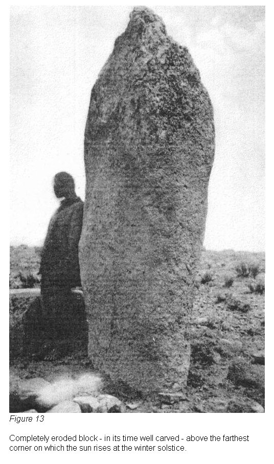

figs 13, 13a, 13b
All that which is still standing of the
Third Period in Kalasasaya is worked
exclusively in hard andesitic lava, as for example, the balcony wall, the
sanctissimum and the reconstructions of the Second Period. But it is not only in
the material that the Third Period differs from the preceding one; it is
especially in the so perfect working of the rock, a thing unsurpassed in the
world up to this time. It is seen further in the symbolic style of the
engravings which are extraordinarily advanced and especially, in the astronomical
orientation of its construction which shows a variation of 25' 30" between
one period and the other.
The orientation of the south wall of Kalasasaya of the Second Period is 89°
18', of the north 89° 20', of the east 358° 58' 30" and of the west 358°
53' 30". The constructions of the Third Period such as the sanctissimum and
the balcony wall, deviate from the meridian to the west 42', or they were
located at 359° 18'.
Bronze appears in the Third Period. One frequently notes the repairs in the
walls of former periods in which they joined blocks by means of bronze bolts;
these they used in different shapes for their own constructions, even in the
form of rings, fig 14.
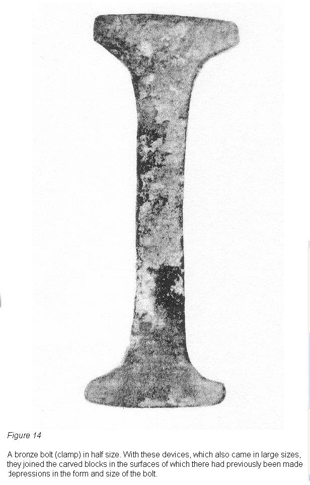
fig 14
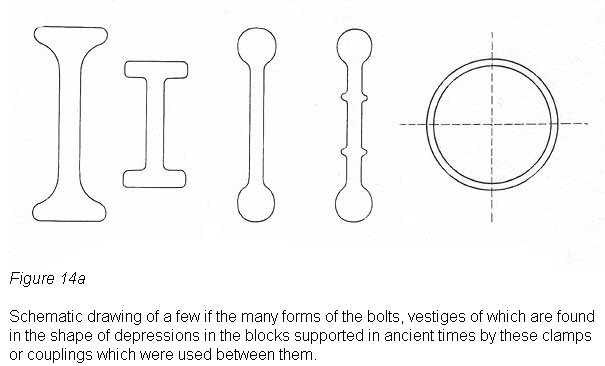
fig 14a
In this very period, characterized by a maximum
advance --- it constitutes the epopee of Tihuanacu --- the "Loka" also
appears, a common, everyday unit of measure which, to judge by the construction
of the balcony wall, had a length of 161 cm. 3.25 mm., equivalent possibly to
the arm span of the average individual of that time. (See our work: "Antropología
y Sociología").
The Sun Door is the most glorious monument of this period. An attempt was
made to finish the buildings of the First and Second Periods, as we shall see
farther on, especially the Temple of the Moon, Puma-punku and the
Pukara Akapana,
but they were not concluded. With the exception of the Temple of the First
Period, absolutely nothing is finished in Tihuanacu, not even the supreme piece
of this period, The Sun Door, as we have seen in the preceding chapter.
Tihuanacu of the Third Period is a megalomaniacal work like the Tower of Babel
and, had it been completed, it would possibly have surpassed everything that man
has constructed on the earth.
Among the sciences they came to know, as we shall see farther on, they mastered
the astronomical bearings of the meridian, with which it was possible to
determine the exact "amplitude" of the sun in the Third Period and
with this, in turn, the obliquity of the ecliptic --- a value which has supplied
us with the basis for determining the approximate age of Tihuanacu.
By means of
this knowledge the equinoxes and solstices were established, the aphelion and
the perihelion were known, the solar year divided into twelve months was used.
Even the zodiac became known, as has been seen in the previous chapter which
deals with the Sun Door, but in a form quite different from that known by the
ancient Semitic sages of Chaldea, whose knowledge was passed on to the astronomy
of the present day.
|
(61) Cf. in this connection: Posnansky,
Antropología y sociología de las razas interandinas y adyacentes,
p. 106; Isla Simillake y sus edificios, Las Paz, 1937.
(62) Later we shall give the exact
length of each one of the four walls, obtained by triangulation.
|
|
|
|
Back |
|
|
5. The Astronomic Science of Tihuanacu. How Kalasasaya was Built to be Used as a Stone Almanac
(Plan III)
|
|
As was pointed out in another section,
in order to construct the quadrilateral of Kalasasaya of the Second Period, with
the purpose of having this serve to determine the seasons of the solar year with
their subdivisions, it was necessary for it to have special form and
orientation, or for the east and west walls to be located exactly on the
meridian and especially, that the PROPORTION BETWEEN THE LENGTH AND WIDTH OF THE
BUILDING CONFORM TO THE MAXIMUM ANGLE OF SOLAR DECLINATION BETWEEN THE SOLSTICES
OF THAT TIME.
The problem was not a difficult one, as the careful observers of celestial
phenomena of that time, who were the priests and rulers, and who certainly
constituted special castes of Kholla stock,
(63) had preserved the traditions of
many centuries of observation and experience.
Neither is there the least doubt that before venturing to construct the great
Temple of the Sun, they had in Tihuanacu itself, or previously at some other
point of one of the large islands or peninsulas of the inter-Andean lake, an
adequate and prominent site with an horizon free of elevations and relatively
flat to the east, (64) (or perhaps a similar building on a smaller scale), in
which they obtained their great experience in making observations and
determining the dates of the year. In the construction of that primitive, or let
us say, trial solar temple, their knowledge was, without doubt, developed little
by little. They became familiar with the celestial phenomena, until they
attained the summum of learning to be able later to venture the construction of
this great Temple of the Sun of the Andes.
Possibly one of these trial
observatories was that of Lukurmata, which we discussed at the beginning of
subchapter "B."
Let us consider now what methods they used in the acquisition of this knowledge.
Since for these precise calculations they did not have at their disposal, as we
do, such instruments as theodolites, sextants, astronomical almanacs, etc., but
only sundials (65), plumbs, levels
(66) and topos
(67,67a) we are led to
wonder whether with such ordinary, though at the same time such efficient means,
they could carry out unquestionable celestial observations; this, of course,
from their anthropocentric point of view, in which they believed the earth to
be the center of the universe, around which all the celestial bodies moved, and
Tihuanacu the center of the earth, taking into account the age-old observations
of the atmospheric phenomena. It should not be forgotten that in very ancient
times not only the
residents of Tihuanacu made
astronomical observations of unquestionable value.
In China, 2,700 B. C, during
the reign of Wuwang in Lo Yang, they observed and determined the obliquity of
the ecliptic, measuring with a sundial nine feet high the shadows in the
solstices. The emperor Tschukong in the year 1100 B. C. measured the obliquity
of the ecliptic (68) and
Eratosthenes (born 276 B. C.) reckoned it at 23° 51'
15". (69)
Thus it is that China, Babylon and Chaldea gave to humanity the
celestial circle of 360° which we still preserve in our astronomical
measurements, atlantes, maps, geometry and all the calculations which have
angles as their basis.
Why then could the Tihuanacuans not have determined, during the solstices, the
line of the meridian on the basis of measurements of the corresponding shadows?
Why could they not have determined the solstices with their famous topos, taking
points of observation between marks on the horizon, which would indicate the
maximum oscillation of the sun toward the north and six months later toward the
south?
There are still many other primitive methods which they might have used
as a basis for determining the line of the meridian, knowing the amplitude of
the sun between the solstices. But there are also ordinary systems for obtaining
in a single night, with the primitive resources mentioned above --- which
without any doubt they had at their disposal --- the line of the meridian with
considerable accuracy. I shall present here a very eloquent example to show how,
through the culmination of some fixed star and with the ordinary resources we
have mentioned, they could have arrived at the line of the meridian.
They would have searched in the firmament toward the South Pole for a
circumpolar star; they would stretch a tape line more or less from east to west
(a line familiar to them since in the equinoxes they saw the sun rise and set on
that line) ; they would true the line with a level, Fig 15,

Fig 15
they would string
on this two small perforated discs of stone or wood; they would place a block of
stone or adobe in front of the tape line and on it an observation topo (sight).
The priest-observer, would kneel in front of the topo and wait until the
star passed the line on the left "toward the top" and he would instruct his assistant to move the small disc of wood
to the spot where the star passed through the line; they would then have
waited some hours until the star had culminated and again passed through
the line "downward" so that the assistant could place the second disc
in the corresponding location.
They would wait until daytime and then would
divide the space between the two discs in half, from which they dropped a plumb
to the ground. Then they would take another line with which they could obtain a
straight line from the hole of the observation topo to the plumb and
would prolong the line. THIS STRAIGHT LINE WAS THE LINE OF THE MERIDIAN. At a
great distance from the line thus obtained, they marked their "sight",
which at the present time is visible on the hill Quimzachata, in the form of a
white circle which can be distinguished perfectly from the balcony wall of the
Third Period.
In order to determine what degree of accuracy could be obtained in the
determination of the meridian with this ordinary method of observation, we made,
in the year 1928, and in company with one of the astronomers who had come to
Bolivia with the German mission, a similar calculation. We used nothing more
than a tape line, a level and a plumb; for discs we used two empty spools which
we strung on the line and not having a topo de observación at hand, we
improvised one from an empty sardine can, perforating it in the center and
fastening to the side a stick sharpened to a point on the end which we stuck in
the ground.
My companion, stretched on the ground, observed the culmination of
the star and I, following the directions of the improvised "observer",
moved the spools along the line; then we divided in half the distance between
the two spools and from this point (one half of the line) we stretched a
straight line to the center of the improvised topo de observación (the
hole in the tin can); simultaneously with this empirical operation and in order
to test its relative accuracy, we made that same night and on the same
spot a calculation with a theodolite, based on the same star. Comparing both
operations, a slight difference was apparent.
(70)
By repeating these ordinary observations and striking an average for all of
them, one would get an exact calculation. There is not the least doubt that the
priest-astronomers of Tihuanacu, in order to determine their "sight",
made not only one observation, but perhaps hundreds of them. This probably went
on over a long period of years until they were in a position to establish the
"definitive line of the meridian" on a building of the magnitude and
importance of that of Kalasasaya, the stone calendar of the most civilized
inhabitants of the America of that time.
Also, without the direct establishment of the meridian, with which they
would not have obtained the proportion of width and length of the building, the
plan and subsequent construction of the cardinal walls could have been
effected much more advantageously, exclusively on the basis of careful
observations, at each six months of the solstices, or in the following manner.
For an exact observation of the solstices there could have been built on the
site where today the center of the primitive west wall of Kalasasaya of the
Second Period is found, a platform
(71) of relative height, on which they would
have erected the "observation pedestal", (Pl. XV). In order to
determine the solstices from this point they could have made a simple apparatus
more or less in the following form and using only the primitive materials which
they had at hand.
Since they were clever forgers and smelters of bronze they
could have prepared a simple apparatus in the form of a box or cover the size of
the last step of the aforementioned pedestal, over which it would be fastened.
Then almost on the edge of the cover near the observer, there would be bored a
central hole. (Cf. the reconstructed drawing, Fig 16.)

Fig 16
Next on this bronze
cover set on top of the "observation block" with the hole as we have
indicated, they would place a strip of bronze, silver or gold, let us say some
10 cm. wide and 1 cm. thick. This was something less than 73.4 cm. in length,
the diameter of the platform of the pedestal, and both of its ends were pointed,
Fig 17.

Fig 17
Each end of the strip would be drilled so that there could be placed in them the
observation "topos" in a stationary manner. This would be done in such
a way that the one near the observer would pass through the strip about a
centimeter like a spike. The latter would be introduced in the upper hole, or
the hole in the bronze cover, and in this way the strip with its two "topos"
would be free to swing freely on the cover.
In this very simple manner they could have made an apparatus which today we
would call a sight or a diopter.
(72) Its manipulation was extremely simple as
can be seen in fig 18

Fig 18
and looking through the two holes of the "topos"
they would have observed not only the rising of the sun in the solstices, but
also daily and during many years, marking carefully the maximum oscillation of
the sun toward the north and to the south. Thus they would obtain, easily and
simply, an angle which would constitute the total amplitude of the sun between
the two solstices, the vertex of which would be the spike of the first
observation "topo."
Then they would have only to prolong each side of
the maximum angle with lines or sights and on the prolongation of each side of
the angle measure a fixed distance, let us say, eighty "lokas" (the
normal unit of measure of Tihuanacu in the First Period).
(73)
Next connecting
the ends of these two points they would have a line corresponding to the EXACT
MERIDIAN AND AT THE SAME TIME THE PERFECT LINE OR DIRECTION OF THE EAST WALL FOR THE SUN TEMPLE,
their stone calendar, which served to furnish the exact dates of the year to the
dense population of farmers and graziers of Cameloidea who were their
subjects.
Later, to obtain the exact directions of the other three walls, they had only to
strike a right angle at each end of the direction of the east wall already
determined, which in their turn would constitute the lines for the south and
north walls. The west wall was the parallel of the east wall and naturally
intersected mathematically the primitive observation point of the solstices
which was the opening for the first "topo."
This system which we have
just described was, in our opinion, the one which the priest-astronomers
of Tihuanacu could logically have used, and preferably to construct the
Temple of
the Sun, Kalasasaya, in the Second Period. Naturally, this system could
be used
only in the event that to the east there existed a true horizon and not
one
similar to that of the present time which is located some 15 kilometers
away,
(Cf. profile of levels, Vol. I. Pl. I) covering the true horizon and
giving rise
to a false horizon.
Thus it is that looking today from the observation point
toward the northeast corner of Kalasasaya, there is an elevation of 2° 47' and
toward the southeast corner one of 0° 16'. In the long space which separates us
from the construction of the Second Period of Tihuanacu, which is presumed to
be, as will be shown later, from ten to fourteen thousand years, there were, in
our opinion, definite tectonic movements and alluvial accumulations which
undoubtedly could have changed the topography of the high plateau. On the
subject of tectonic changes, we presented a paper in 1931 before the
Twenty-third International Congress of Americanists meeting in New York City
entitled "La remoción del cíngulo climatérico como factor del despueble del
Altiplano y la decadencia de su alta cultura".
On the basis of the
explanations set down in that work, we presume that when they planned to
construct Kalasasaya, there was perhaps an almost free horizon to the east. But
in the case that the present hills extended toward the east at the time of the
Second Period, they still could have constructed the temple in the same place in
an exact mathematical manner, in the following way. With a sight similar to the
one described above --- in a temporary observatory near Tihuanacu --- (for
example the already mentioned one of Lukurmata or one on an island in the lake
where to the east there would have existed an apparently free horizon) they
would make note of the solar amplitude and mark the angle on the metallic plate
underneath the sight.
Later, on the spot where they wished to construct the
"east wall", they would determine the line of the meridian and from
the middle of this line they would strike a perpendicular. At the distance that
they believed fitting for the size of the building they would set on the
perpendicular line the observation point, and on it the sight with the angle of
amplitude brought from the temporary observatory, and they would prolong the
sides of the angle until they struck the line of the meridian. Of course,
previously they would have divided the angle of solar amplitude in the middle
and then would proceed in the manner described above for the plan of Kalasasaya.
Carrying out this operation, as without doubt they must have done, the people of
Tihuanacu were the first to observe the obliquity of the ecliptic. Thus, without
question, Kalasasaya must have been constructed, using one or the other of the
systems which we have studied and described. Kalasasaya being divided
longitudinally into equal parts and, of course, also the angle of solar
amplitude, they believed likewise that they had divided the year into four equal
parts. This belief proved to be erroneous and later they had to rectify it, as
we shall see subsequently when we consider the great monolithic perron which, in
the east wall, gives access to the Temple of the Sun.
Another problem presents itself: after various careful triangulations carried
out in the interior of the great enclosure of Kalasasaya, we discovered that the
angles of its four corners were not completely right at the present time. Those
of the southeast and northwest are somewhat acute while those of the northeast
and southwest are slightly obtuse. We transcribe herewith the measurements of
these angles made by Professor Arnold Kohlschütter, Dr. Rolf Müller and the
author.
Angles of the Corners of Kalasasaya
| Southwest |
Southeast |
Northeast |
Northwest |
Observer |
|
|
|
|
|
| 90° 19' |
------- |
------- |
------- |
Müller |
| 90° 29' |
89° 29' |
90° 27' |
89° 36' |
Kohlschütter |
| 90° 19' |
89° 37'
13" |
90° 20' 41" |
89° 43' 5" |
Posnansky |
The lack of rectitude in these angles
causes the east wall not to be orientated on the meridian at the present time
and gives it a deviation of 1° 1' 30"; that of the west shows a deviation
of 1° 6' 30". The north and south walls, instead of being orientated
mathematically in a north-south direction, show deviations. The north wall shows
a deviation of 40' and the south 42'. The verification of the German Mission is
as follows:
| South Wall |
West Wall |
North Wall |
East Wall |
Observer |
|
|
|
|
|
| 89° 24' |
358° 55' |
89° 20' |
358° 53' |
Kohlschütter-Becker |
| 89° 12' |
358° 52' |
------- |
359° 4' |
Müller-Posnansky |
| 89° 18' |
358° 53' 30" |
89° 20' |
358° 58' 30" |
AVERAGE |
Dr. Müller believes that this small deviation with the resultant lack of
absolute rectitude in the angles was intentional and he gives the basis for his
opinion in his aforementioned work (Baesler-Archiv).
As far as we are concerned, we believe that Kalasasaya in its time was
correctly and mathematically orientated, not only with relation to the meridian
but in the angles of the corners of the building and that it is not a question
of any error on the part of those conscientious, prehistoric architects and
astronomers.
This seems logical, for a native mason draws right angles today
using the systems employed by architects and builders with a maximum margin of
personal error of 6'. As the basis for this opinion which we have just set down,
the following should be stated. All of the valley of Tihuanacu including the
site where the ruins are located, is composed of sandy clay and represents an
ancient glacial lake bed on the edge of which, without any doubt, Tihuanacu of
the Second and Third Periods was located. (Cf. levels toward Lake Titicaca, Vol.
I, Pl. I).
The builders of Tihuanacu set out to construct that great work
without possessing the knowledge of architecture which man had in later periods,
a knowledge which could be acquired only through the experience of thousands of
years. The architects of those times were as yet unfamiliar with the system of
putting foundations under the buildings and especially under the megalithic
blocks or the lower structure, "the groundwork".
That is to say, to
prepare first a base in the subsoil, rather wide and composed of a compact
concrete of stone or masonry so that the foundations of the building --- which
support all of the weight --- would not sink or get out of level when the
subsoil became damp or moved. Megalithic Tihuanacu has no foundations and if it
did have, its buildings, as solid as any in the history of architecture, would
still be standing today perfectly intact.
(74)
It is a recognized fact that clay soil moves when the humidity penetrates to
some depth in periods of intense and prolonged rain, and especially when steps
are not taken to prevent this by means of paving or some other form of
protection of the soil which will prevent the penetration of water. Naturally,
in locations having but slight declivity, the slipping is scarcely measurable
even after several centuries. If the studious reader will consult the general
map (Vol. I, Pl. III) with its curves of level, he will note that the part of
Kalasasaya which is resting on the hill of Akapana, almost forming a block with
it, is the south wall of this temple, where on this account the slipping, if
such there were, must have been negligible.
Thus, this wall shows a deviation of
only 42' from the cardinal east-west line. The same is true of its parallel
which to the north has a deviation of only 40'. As for the east and west walls,
they have deviations of 1° 1' 30" and 1° 6' 30", respectively. This
data could not be more eloquent. The south wall has remained, being connected to
the hill Akapana, almost in its original position. With regard to the north
wall, it has slipped toward the west, or rather toward the lake, pulling with it
the east and west walls.
Also, some 150 m. to the north of the temple, there extended an arm of the lake
and this in the same way was one of the causes for the slipping of the land in
that direction. But the most obvious proof of the movement which took place in
the subsoil is to be seen in an indisputable manner in the excavation carried
out on the floor of the small semi-subterranean temple of the First Period (Cf.
Vol. I, Pl. VII). Here can be seen a drainage canal which has lost its lineal
form through the movement of the subsoil, and is laterally entirely twisted, and
curving.
This temple with its drainage canal (Cf. infra its reconstruction) is built in
the subsoil. After the destruction of the metropolis it was filled with alluvium
and shows perfectly the tectonic disturbances of the lower ground. In that
period the aforementioned canal was straight, well-lined and leveled, with a
small declivity toward the north branch of the lake, so that the rain waters
which fell within the enclosure of the roofless building would run toward it.
Another factor which might have contributed to the loss of rectitude in the
angles of Kalasasaya, could have been the process of shrinking of the strongly
soaked clay soils which contract more where they receive the sun and winds on
one side. In short "to err is human". We shall not be the last to
study the astronomical, geodetical, topographical, geological and stratigraphic
phenomena and problems which today present themselves as indecipherable enigmas
in Kalasasaya. Others will follow, perhaps with more preparation, with more
patience and especially with better instruments, greater time and means, and
they will check our studies and give a definitive verdict in this difficult
material.
Now we shall consider another point of great importance with respect to
Kalasasaya: that of the massive perron which gives access to this significant
and useful monument of American man.
This staircase is not in the center of the east wall of the building as would be
demanded by symmetry and all architectonic standards. Not the slightest
architectural consideration caused the massive staircase to be 1m. 116 mm. to
the north.
Interested for a long time in this problem, the author advanced various vague
opinions and hypotheses in former publications, which of course are superseded
by the present publication. Discussing this knotty problem on various occasions
with Dr. Müller, the opinion of the author of the present work was always that
expressed by Dr. Müller on p. 8 of his study "El Concepto
Astronomico",
or in other words that the perron had to mark a main calendarian point for the
time of the equinoxes. Already at that time the author pointed out that the
deviation of the staircase from the intermediate line of the building of
Kalasasaya must have some relation with the perihelion and the aphelion of the
terrestrial orbit. And thus is the case.
(75)
The sun not being in the center of
the orbit but in a center of the eclipse in which the earth turns about the sun (Fig 19)
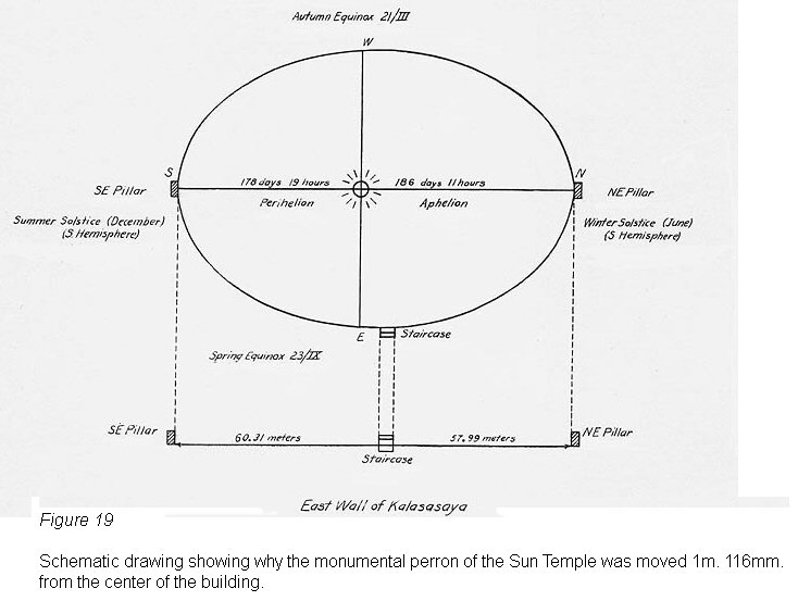
Fig 19
the earth needs a greater length of time to go from the autumnal
equinox to the winter solstice and return to the vernal equinox than to go from
the vernal equinox to the summer solstice and return to the autumnal equinox.
(76)
That is to say, that for the moving of the earth from the twenty-first of
March (autumnal equinox) to the twenty-third of September (vernal equinox) it
needs 186 days, 11 hours (winter) while to travel from the vernal equinox to the
autumnal equinox it needs only 178 days, 19 hours (summer). Thus there is a difference of 7 days and 16 hours between the winter and summer
semesters. This is the crux of the problem as to why the perron of Tihuanacu is
not in the center of Kalasasaya but is located 1 m. 116 mm. to the north. Let us
explain this in simpler form.
After the priest-astronomers of Tihuanacu had
established --- we may presume with the system of the "topo" sight ---
the northeast and southeast corners (the solstices) of Kalasasaya, and after having
logically divided the angle in half, they thought that they had also divided the
year into four parts. However, in practice they noted the aforementioned fact
that the sun needed more time to go from the north to the center of the building
than from the south to the same place.
Thus, since they wished to divide the
year into four equal parts, they made further observations in order to determine
where the sun would rise at the exact middle of the year, on the twenty-fourth
of March and the twenty-first of September, and they then noted --- surely with
no little surprise --- that the sun did not rise in the center of the temple but
1 m. 116 mm. to the north. With this observation they were
perhaps the first men in the world to note the perihelion and the aphelion, or
the eccentricity of the terrestrial orbit. This difference corresponds for the
21st of September to 1° 0' 56.3" toward the north and for the 24th of
March to 1° 6' 45.3" toward the south.
(77)
This is the way in which they established the point which marked the rising of
the sun at the exact middle of the year as the center of the massive perron.
This, the principal access to the palace, was at the same time a calendarian
point for the determination of the great solar festivals: in Aymara probably
Kjapak-Tokori and in Quechua, Citua-Raymi (for them the twenty-first of
September) (according to Felipe Guaman Poma de Ayala: Koya-Raymi).
The
twenty-first of September was the beginning of spring for them, the beginning of
the year, and six months later came the "Willka-Tokori" (in Aymara) or the
Inti-Raymi (in Quechua), the beginning of the autumn, the festival of the harvest (according
to Guaman Porna: Inca-Raymi; making a mistake of a few days he designates it as
"April").
The solstices, the "Willka-kuti"
(78) were
festivals of prayer in which the sun was implored not to go farther away but to
return and favor man with its light and benign heat. These principal
agricultural periods and astronomical seasons gave rise to great festivals and
the determination of their dates was the motive for the construction of the
great Temple of the Sun in the Andes.
Other important dates connected with
agriculture or the raising of cattle were certainly determined by the rising of
the sun over this or that column and were accompanied by their respective
celebrations. Thus, there is almost no doubt that the rising of the sun in the
center of each pillar of the east wall, and later the setting of the sun on the
pillars of the balcony wall to the west, signified important dates in the life
of man of that time.
The west balcony wall which belonged to the SECOND PERIOD, is not in existence
at the present time and we have found only remains of the short corner wall of
the south side. On June 18, 1939, we discovered remains of the north side.
(79)
At the present time, these connect the west wall with the balcony wall of the
Third Period, or they may be the structural prolongations which connect it with
the northwest and southwest pillars of the wall of the Second Period. As we
shall see farther on, only the balcony wall was completely replaced in the Third
Period. Its principal object was to guard the tabernacle of solar observation
and its mysteries from profane eyes.
At about two meters from the center of the west wall of the Second Period and on
the dividing line of the temple a great slab 2 m. 5 cm. wide, 2 m. 75 cm. long and 25 cm.
thick
(Fig 20).
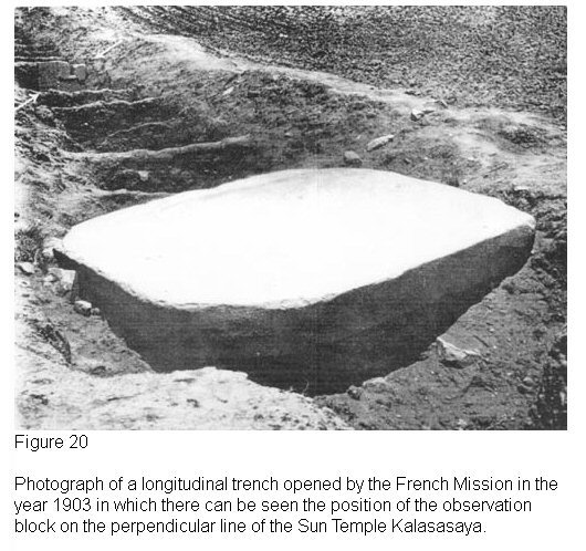
Fig 20
was found. In our opinion this slab has no
connection at all with the observation point or with its base; it belongs to the
Third Period and later on we shall consider its object. Some 8 m. from the slab
and also on the dividing line of the temple, in the course of the excavations in
1903, the piece which we have called the "observation pedestal", was
found. In
Fig. 20
it can be seen at the moment of the excavation, still in its
original place, of in the fifth test pit counting from the great slab.
(80)
On
the basis of the material and the technique, it belongs without question to the
Third Period. At the time of the construction of the modern church of Tihuanacu,
it was covered with earth. It was therefore saved from destruction and only
similar blocks of red sandstone found on the surface and supposedly from the
Second Period were used. At the present time they are enchased in the balustrade
of the atrium of the church, (Vol. I, Plate IV a and Plate XIV a). We judge that
these pedestals may have served a purpose similar to that indicated by the
drawing of the sight.
The north and south cardinal walls of Kalasasaya, as can be seen in the
illustrations of Vol. I, Plate XVII a and b, are of red sandstone and at the
present time consist only of a few pilasters --- today showing a very rustic
appearance owing to erosion --- and remains of the same.
Their object at the
time of the construction of the temple was to support the intermediary walls, as
can still be seen perfectly on the south corner of the west wall of the Third
Period (Plate XV a) and on the walls of the temple of the First Period (Vol. I,
Pls. VI and VII) as well as in the remains of the west wall of the Second Period
which were recently excavated. This technique, which we have called "Kalasasaya",
is still in use in rural constructions, especially in fences, throughout Bolivia
and Peru. It is not unusual to see this very old system in all parts.
The columns today have the appearance of crude stones planted in the
ground.
However, in their time they were not only carefully aligned and carved
but on
the sides facing the interior of the building were magnificent
symbolical
inscriptions as can be seen on a piece that has fallen from one of them
and on
which a part of these drawings has been miraculously saved,
(Figs. 21
and 21a).
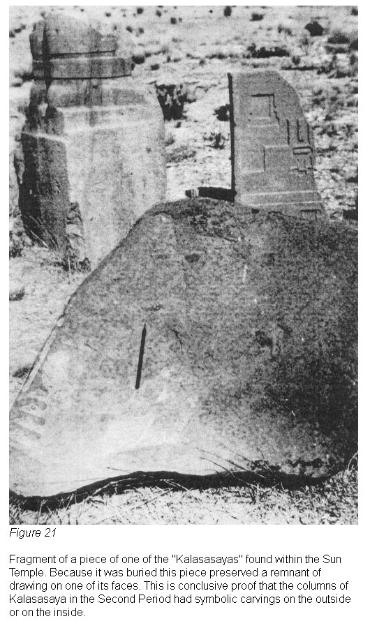
Fig 21
Because of the enormous age of these great pilasters which were the
support of
the walls, some of them have fallen down and others are so thin in
certain parts that they threaten to
fall over from one moment to the next.
At the present time nothing is
being done
to preserve this precious monument which still serves, as it has for
centuries, as a quarry for the inhabitants of the region. Possibly they
were also enchased with carved human heads, as in the walls of the
temple of the
First Period, (Cf. aforementioned figures). This idea is supported by
the
discovery --- from the Third Period --- of intermediary blocks which
show such
carved heads and in the most perfect technique of that period,
(Fig.
22).
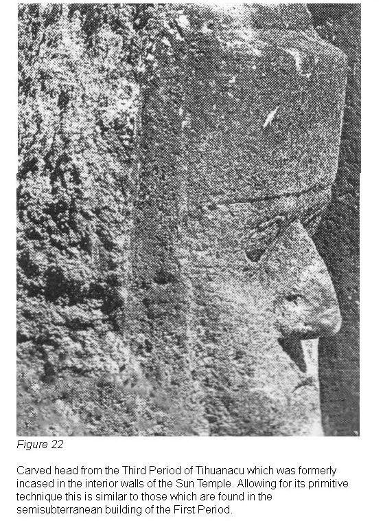
Fig 22
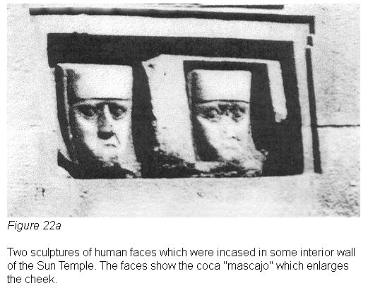
Fig 22a
|
(63) Cf. Posnansky, Antropología y
sociología, Figs. 8 up to 30.
(64) There exist various "Kalasasayas"
on the Altiplano as, for example, in Chiripa, Cumana, Lukurmata, Khonto,
Kaskachi, Merkhetihuanacu and other places.
(65) Jean Baptiste Biot, Recherches
sur I'ancienne astronomic chinoise Paris, 1840.
(66) We have seen a level of Tihuanacu,
taken to London by one Mr. Thomas Richards. (Cf. the corresponding figure, infra.
(Fig. 15.))
(67) Bronze, silver or gold sights in
the form of a flat spoon with a hole in the spoon-shaped part.
(67a) In the Museum of the American
Indian (Haye Foundation), New York City, there are "observation topos"
of silver, the largest of which is 46 cm. long. (Cf Fig. 16a in Vol. III).
(68) R. Müller, op. cit., gives
(according to Wolf) 2100 years B. C. instead of 1100.
(69) Id., gives (according to Wolf) 23°
45' 1" instead of 23° 51' 15".
(70) Dr. Müller in his work "El
Concepto Astronómico del Gran Observatorio Solar Kalasasaya" (Anales de
la Sociedad Científica de Bolivia, Vol. I, p. 6) says: "Out of
curiosity and in company with Prof. Posnansky, we carried out, without using any
instrument, a determination of the meridian based on the culmination of stars
and as a result of that test it was seen that it is possible to obtain good
results by ordinary means by making a number of observations".
(71) Recently, upon building a road in
this locality, remains of foundations were found, possibly from a building used
for observations.
(72) That in the Third Period and
perhaps also in the Second they used and worked bronze perfectly, is obvious
from the large metal bolts with which they joined the gigantic stone blocks in
Puma-Punku and from a great variety of bronze objects found in the excavations.
This apparatus itself might have been made of wood in the beginning, but
naturally this would not have the lasting qualities of bronze for extended
observations.
(73) The "loka" of the First
Period of Tihuanacu was 174 cm. as can be seen clearly in the preglacial
building on the island of Simillake in the Desaguadero River (Cf. Posnansky: Antropología
y sociología andina, 1937). For example the semisubterranean building of
the First Period of Tihuanacu is 2890 cm. wide (16 lokas) and 2600 cm. long (15
"lokas"). Each "loka" of the First Period measures 175 cm.
The building of Simillake has thirty "lokas" of the First Period. With
regard to the "loka" of the Third Period of Tihuanacu it is only
161.51 cm. refer to the balcony wall of Kalasasaya. But in the Second Period, which
has more connection with the First than with the Third, it seems that the "loka"
had the same size of 175 cm. as in the First Period. For example, the width of
the perron of Kalasasaya is 4 "lokas" and that of the sides of the
CONSTITUENT ANGLE of the Kalasasaya of the Second Period has 80 "lokas"
of 175 cm. The change in the size of the "loka" of the First Period of
Tihuanacu is due, in our opinion, to anthropological reasons. The difference in
the arm span (basis of the "loka") of the primitive men of the First
Period, or a length of 13.49 cm., corresponds to the greater physical
development of the man of this period as compared to the man of the Third
Period, more developed intellectually but with a correspondingly reduced
physical development.
(74) Last but not least, if the later
destruction caused by man had not taken place.
(75) Cf. Müller: "Der
Sonnentempel in den Ruinen von Tihuanacu", Baesler Archiv, pp.
132-133.
(76) We are, of course, referring to
the southern hemisphere in which is situated Kalasasaya.
(77) Data for the year 1919.
(78) Cf. Vocabulario of Bertonio,
Spanish-Aymara Volume, p. 436.
Guaman Poma in his Crónica calls the
solstice of June "Huaucay quisqui" and that of December "Inti
Raymi." In support of the supposition that in Cuzco in very ancient times
there were also "sign posts" which marked the sunrise, we note what
Polo de Ondegardo said in his book Los errores y supersticiones de las Indios,
1571 (that is to say, a few years before Guaman Poma began to write his Crónica).
In Ch. 7 he says: "They divided the year into twelve months by the
moons. Already, each moon or month had its marker or pillar around Cuzco, where
the sun arrived that month."
(79) We should point out that this
communication between the balcony wall of the north side of the Third Period
with the west wall of the Second Period was effected in the Third Period as we
proved personally in our excavation carried out the 18th of June, 1939. In this
operation this wall replaced, without any doubt, a previous sandstone wall of
the Second Period.
(80) Test pit of the Crequis de
Montfort Mission, 1903-1904.
|
|
|
|
Back |
|
6. The Approach to Kalasasaya.
The Monumental Perron
|
|
In considering
Kalasasaya of the Second
Period of Tihuanacu, it is necessary to pay particular attention to a
construction of great importance, not only from the astronomic but also from the
monumental point of view. This is the megalithic perron. In the preceding
chapter we pointed out the importance of the center of the perron AS THE
INTERMEDIATE DIVISION OF THE YEAR OF TIHUANACU.
Now we shall concern ourselves
with the details of this magnificent architectural work.
The perron
(Fig. 23)
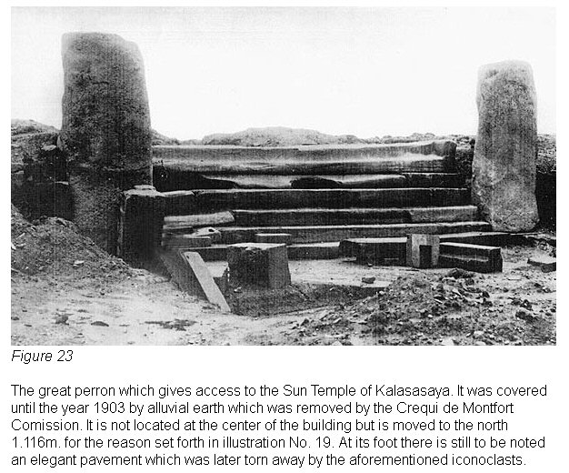
Fig 23
is located as the principal access to Kalasasaya through
the east wall, but it is not in the exact center of that construction. Rather,
it is located one meter, one hundred and sixteen millimeters to the north, for
the reasons set forth in the foregoing chapter.
Bordering it on both sides are
two large pilasters, which lend this architectonic work an even more monumental
aspect. In contrast to the stair, which is of red sandstone, the pilasters are
worked in hard andesitic lava. Comparing their erosion with that of the works of
the Third Period found in the same location, it can be seen that a great space
of time must have transpired between one period and another. We shall consider
this very important point later on, in the study concerned with the age of
Tihuanacu.
The stair steps, which in the main are composed of monolithic blocks, are seven
in number; the last two on top form the platform and are made of a single piece.
On the top of the platform there is a superstructure as revealed by the
"design made by erosion" in those places where the superstructure does
not extend, (Fig. 24).
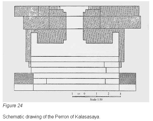
Fig 24
Since this place --- shaded in the illustration --- shows
absolutely no erosion from the atmosphere, or let us say from time, it could be
presumed that during the period of the Conquest it carried a part of this
construction on the platform of the stair, and that the blocks which composed it
were used by the perverse destroyer of that epoch in which the church of the
village of Tihuanacu was built.
At the present time we see in relief the material which formed the base of the
superstructure, or of the platform. However, as can be still observed clearly in
the base and pedestals of Puma-Punku, "depressions" must have been
produced in the block of the base where it fitted, or more exactly, the
superstructure was implanted, and only as the result of the erosion of thousands
of years did depressions deeper than the original higher parts finally remain on
the platform of the stair.
The upper construction on the platform was of the strangest type and completely
contrary to our present architecnographic ideas, which would have demanded an
ample entrance to the temple. Consequently, it was not, judging from the
amplitude and magnificence of the perron, designed for the entrance of
magnificent processions or enormous masses of people during the ceremonies and
liturgic celebrations connected with the worship of the sun. Rather, the
entrance was narrow (approximately 1 meter 45 centimeters wide) and possibly
built for very exclusive use. The priests certainly walked through it during the
most solemn moments of the celebration of important proceedings connected with
the mysteries of the Sun Temple.
This super construction belongs to the Third Period and was an integral part of
the "sanctissimum" with which it communicated directly, since the
alignment or interior edge of the platform is in line with the external east
wall of the "sanctissimum", on the extreme north end of which is still
found the pillar of the winter solstice of the Third Period,
(Fig. 25).
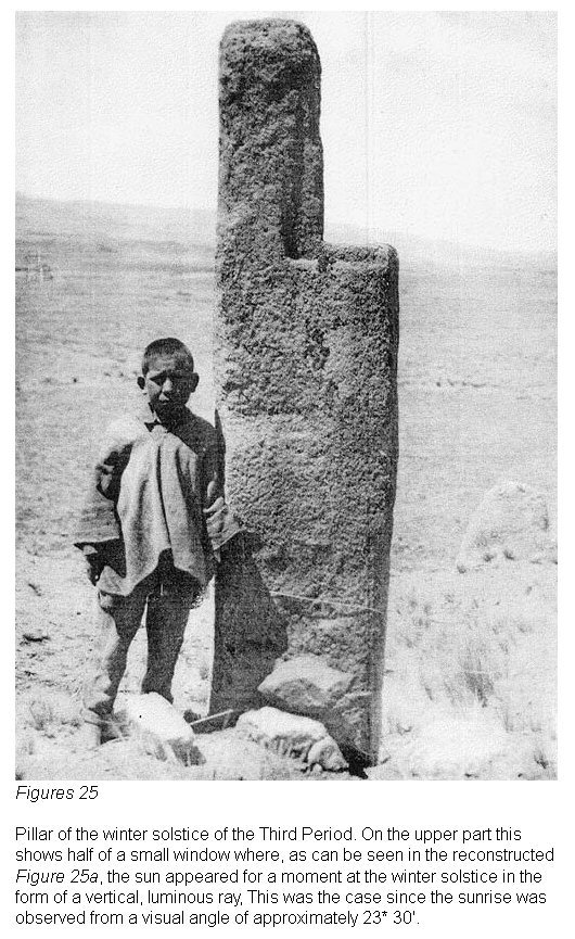
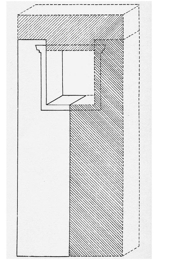
Fig 25 and fig 25a
In
short, although more than ninety percent of Kalasasaya is destroyed, and there
have come down to us only the remains of the building's skeleton, little by
little, and especially when serious reconstructive excavations are carried out,
greater light will be shed on the tangled secret which, until a little while
ago, still covered this famous "Temple of the Sun."
The general map (Pl. III) and other detailed maps inserted in the present work,
show clearly the arrangement and outline of the perron and the astronomical
marks which we have left on the platform for future investigations and
calculations.
|
|
|
|
Back |
7. Kalasasaya of the Third Period
|
|
As was pointed out at the beginning of this chapter, we can see perfectly two
periods of Tihuanacu in the construction of Kalasasaya: the Second and the
Third. We have considered before and in some detail, the works of the Second
Period. We have only to discuss the constructions of this last period.
First of all, to this period belongs the balcony wall which took the place of a
similar wall of the Second Period --- probably in the same location. The balcony
wall also had as one of its objects, just as in this period, the screening from
the eyes of the profane the mysteries of the priests when they made their solar
observations to determine the seasons, festival dates and everything connected
with these matters, or in other words, the calendar.
Chronologically, there
belongs to this wall the building located within the great space which we call
"sanctissimum", and in addition the Sun Door and the
"repairs" carried out with magnificently carved blocks and set in the
main east wall. These blocks are very noticeably distinguishable from the
primitive ones (also of andesitic lava) of the Second Period, because of the
different technique employed and the minimum of abrasion through erosion,
(13a).
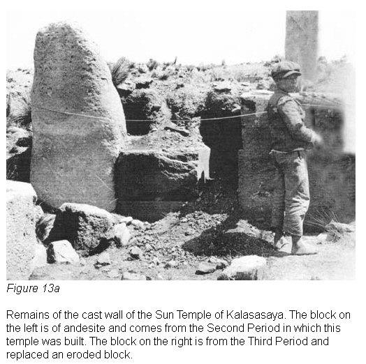
Fig 13a
In the year 1903 and the beginning of 1904, the
Crequi de Monfort Mission made
various excavations in Tihuanacu and in the course of one of them a cut was made
from east to west more or less through the center of Kalasasaya. In this
excavation there appeared the perron and later, in a trench that was opened, a
quantity of magnificently carved blocks, (See Map III). Among these, now near
the west wall, there appeared a great flat slab with a smooth surface.
A little
farther back, or toward the east, there was found a stair with two steps in one
piece and another block of longitudinal form which has a depression, a sort of
indentation, which doubtless served to place in it another standing block for
which the former served as a base. But the most important thing found upon
opening that trench, was a block of a certain special extremely rare trachyte,
(Fig. 26)
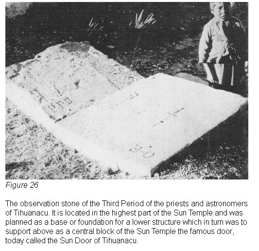
Fig 26
obtained only many leagues from Tihuanacu, and which showed evidence
of having been brought from a great distance.
This block, which is in the
highest part of the temple, forms the crowning part of the external west wall of
the "sanctissimum" and as such was supposed to serve, in our opinion,
as the base for the Sun Door; that is to say, when the base and the Sun Door
were completely finished. This block which we have designated as one of
"observation" of the Third Period, for reasons which we shall study
later (fig 26) is, naturally, only the central part of a basic wall which
must have existed formerly and which today has disappeared like almost all of
the component parts of the "sanctissimum." From such blocks, we
repeat, they also constructed the temple to the new faith, the Catholic, in the
modern village of Tihuanacu.
As can be seen clearly in the general map of
Kalasasaya inserted in the present
volume, and especially in the side views, the "observation block" is
on its perpendicular, and is located on the highest part, and at the same time
in the center of the palace. It represents the most prominent part of the
construction which we have called the "sanctissimum." This building,
encompassed within the enclosure of the temple, constitutes a quadrilateral
which in its proportions has a LENGTH-WIDTH INDEX of 89, the index of Kalasasaya
of the Second Period being 91. Of course, this small difference is no
coincidence or accident as we shall see farther on. Its size is: length 71.80
meters; width 63.60 meters.
The "sanctissimum" --- a small subterranean temple ---is composed in
its circumference of three terraces which in turn form three steps by means of
which this construction is reduced and deepened toward the interior part. But
the most interesting part of the remains of this ancient construction, among all
that which is standing, is the northeast pillar, which served the same purpose
as the northeast pilaster of the Second Period; that is to say, to mark the
Winter Solstice, (Fig. 25).
Fig 25
But the real significance that this block has for our investigations is that it
shows us that the priest-astronomers of the Third Period no longer observed on
the corners of the blocks as happened in the calculations of their learned
forebears of the Second Period, BUT AT THE CENTER OF EACH PILASTER as we shall
also see farther on in the case of the balcony wall.
The andesitic pillar which we are studying (fig25) demonstrates in an obvious
fashion what has just been affirmed. It can be seen that it had a small window
surrounded with the staircase ornament in the typical style of Tihuanacu. Thus
it results that upon observing the rising of the Sun in the Winter Solstice,
from the previously mentioned trachyte observation block of the Third Period, at
the exact moment when the Sun appeared on the horizon or on the apparent
horizon, it lighted the little window for some seconds and from the observation
point there could then be noted a luminous vertical ray.
This was the case
because the glance of the observer passed the little window of the block
obliquely, or at angle of 24° 38'. Naturally, that pilaster was not isolated as
it is today, but formed the corner of an external wall of the "sanctissimum"
and had moreover, as can be seen on the drawing of this block, a superstructure
which- can be studied in the reconstructed picture, (Fig. 25a).
Fig 25a
As well as possible, with the few remains of the "sanctissimum" left
by ancient and modern destroyers, we have measured its exterior dimensions,
which are: seventy-two meters, ten centimeters long by sixty-four meters, twenty
centimeters wide. As regards the internal terraces, the blocks which formed
them, marked on the map (Vol. I, Pl. III) drawn from 1904 to 1912, have almost
totally disappeared. On the new general map of Kalasasaya (Pl. III) inserted in
the present volume, are marked only the blocks which exist at the present time.
The terraces served simply to support the internal walls and on that account had
a width of some 41 m. 90 cm. only.
Also one of the interesting blocks is that of
the north external wall of the "sanctissimum", which contains an
unfinished hole. It is notable that, having begun to bore the block on both
faces, and by the already discovered system of two drills, WITHIN THE HOLE THERE
ARE TWO LATERAL PERFORATIONS which might have served, when the working of this
block was completed, to place a cross wire or diaphragm and cross wires for
stellar observations. Another supposition concerning the object of these
interior, lateral cracks, would be that they were to hold an auxiliary device
which served as a guide for the auger in drilling the mail hole.
Other blocks, admirably carved in the center, have been found in Tihuanacu and
these could have had no other object than to serve for astronomical purposes.
For example, on the bridge near Km. 26 of the railroad to Guaqui, there is a
completely finished block of this sort,
(81) which has been removed from the
ruins, and which still shows the cruciform marks for an alidade. This block,
carved like all those which form that bridge, comes from the destruction of the
monuments of Tihuanacu during the construction of this railroad.
As
has been pointed out before, it is presumable that the supposed
"sanctissimum"
of the Third Period which is found in the enclosure of the Kalasasaya
of the
Second Period, may have been a subterranean temple similar to the
palace or
temple of the First Period, the structure of which we know to its last
details,
since when it was excavated it was found to be almost intact. Recently
there was
also found a small semisubterranean temple in Lukurmata. If this
enclosure of
the Third Period had been finished, there would doubtless have been
placed on
its deepest interior surface the most important sacred part of the
worship of
Tihuanacu.
This was the case with the aforementioned semisubterranean
building
of the First Period, on the interior plane of which, or rather, on its
lower
floor, there was recently discovered the enormous idol more than seven
meters in
height which was placed there in the First Period and later in the
Second or Third period reworked to transform its rough surface.
When this monolithic idol of red sandstone (Grauwake) was excavated in
1932,
there were found with it other smaller sized idols done in the
primitive
technique of the First Period; they showed no subsequent retouchings of
any sort
carried out during the Third Period.
Since Kalasasaya of the Second Period was also perfected and used in the Third
Period, other remains of this same period are discovered on its site, although
for astronomical work and the calculation of agricultural dates and ritualistic
festivals, the astronomical points of that building were no longer used; rather,
there were used only the constructions for this purpose of their own period, or
precisely, the astronomical points determined and accepted for the Third Period,
such as the northeast and southeast corners of the "sanctissimum" for
the sunrises, and the centers of the blocks of the balcony wall for the sunsets.
Without undertaking extensive and conscientious reconstructions of even new,
excavations on the basis of continual and very exact cartography, it would be
difficult to be more definite with regard to the site of the "sanctissimum."
The only presumption that we may make is that the interior walls of the temple
perhaps had, as in the temple of the First Period when it was finished, heads of
human sculpture set in them. This assertion is based on the fact that there have
been found on the site and outside of it, finely carved blocks in the technique
and material of the Third Period, which show human faces in high relief, (fig 22)
Fig 22
From our point of view, the most important is the great rough stone of trachyte
located on the west wall of the "sanctissimum" and which we have
called "observation block" (Fig. 26)
Fig 26
and which we further judge to
have been previously planned as the final base for the Sun Door. This was to be
located on the monumental external wall the center of which, we repeat, was
without any doubt to be the definitive location of the formidable carved mass
which the common people today call "Inti-Punku", or, Sun Door. Later,
when we consider the astronomical science of the Third Period, we shall again
consider this important remnant of the "sanctissimum".
Now it would be fitting to consider the last remains of the megalithic wall
located outside Kalasasaya of the Second Period and which has been called up to
this time, Collonade, Stonehenge, Balcony Wall, Peristyle, Projection, etc. Of
this there remain standing today --- after the destruction suffered in the
building of the temple to the new faith --- only nine great pilasters, one of
which is lying on the ground. The other pilaster which is missing between the
fourth and fifth block, counting from the south, is being used as the foundation
for a native fence, some 242 meters to the west, (Figs. 31 and 31a).

Fig 31

Fig 31a
The direction or alignment of the balcony wall, is typical of the Third Period,
or, on the meridian with the insignificant variation of 42' east. That is to
say, looking toward the south, the balcony wall runs 42' easterly. Because of
this new orientation, it does not run completely parallel to the west wall of
the Second Period, which deviates from the meridian 1° 6' 30" in the same
direction, and thus there exists a difference of 24' 30" between the two
periods.
The wall, of which these pilasters still standing once formed a part, was not
constructed on plumb, to judge by the way it leans in. As we shall see later it
varied inward from the vertical 2°.
That the pillars or columns which formed the balcony wall were in their time a
true wall, is shown in the first place by the remains of a wall still to be
found at the foot of the extreme south pillar. (See Vol. I, Pl. XV a).
Some few
decades ago there must still have existed fragments of intermediate walls
between the pilasters of the balcony wall; these were systematically carried off
by the unscrupulous half-breeds of the village
(82) to carve troughs for hog
food. Neither Squier nor Tschudi y Rivero found the remains of intermediary
walls still on the surface as the illustrations of their works indicate, for
which reason the former called the blocks "Stonehenge".
(83)
Another
evident proof of the existence of intermediary walls, in addition to
the remains
of the walls already mentioned, are the chisel cuts engraved on the
lateral
faces of the pillars and still perfectly visible. In these incisions
there were
formerly inserted or connected the blocks of the intermediary walls.
The principal object of these cracks was to make the stones of smaller
size which
made up the wall form a single piece with the pilasters; in this way
was
supplied the necessary support so that in case of a sudden movement of
the
subsoil, the intermediary walls would not get out of level. In that
period no
mortar or other adhesive substance was used to join the component pieces
of the
construction as is the case in the modern technique and thus those
mortice holes
were indispensable. In addition to this system, as we shall see later
on, they
used metal bolts (Fig. 14)
Fig 14
and stone wedges to fasten the smaller
blocks
together.
The majority of the pilasters which have remained on foot --- these are the
"Kalasasayas" of the Aymara ---show on their tops, notches which
indicate that there was a superstructure, or a construction the completion of
which was planned. This presumption is confirmed by the suggestive fact that all
the pilasters have varying heights (Cf. Pl. III), a circumstance which cannot be
attributed only to the effect of their different bases, since of course the
pilasters were certainly not built on a main foundation extending the whole
length of the wall, as would be the case today.
As has been pointed out in previous chapters, one of the most interesting
details of the balcony wall, is the distance between the center of each of the
pilasters. In this, as has been said before, there has been revealed the normal
measuring unit of Tihuanacu, or the unit of longitude, serving the purpose of
the meter among us:
the "LOKA" of the Second Period,
equivalent to 1
m. 63 cm.
This measure was used by the governing class, especially by the
priests, who certainly were of the KHOLLA race.
(84) It is a question then of an
ANTHROPOMETROLOGICAL measure.
Since this construction constitutes one of the
most interesting details of the Kalasasaya of the Third Period and although a
preliminary plan has already been published in the first volume (Pl. XVI) we
believe it necessary to insert in the present volume a modern plan with greater
details, for the better comprehension of certain points not treated in the
former volume. The interior sloping of this wall to which we refer above,
demonstrates a rather important point of construction.
This is that the wall
made up of the pilasters was not vertically on plumb toward the upper part, but that it had --- and still continues to have
--- a slant which at the present time is about two degrees toward the inside.
This is equivalent to a diminution toward the top of some 38 mm. per meter,
since within they are straight, or, let us say, vertical. In this way they
possibly thought to have given greater stability to the wall of the
construction. Therefore, the pillars are not parallelogrammatic, but become
smaller toward their tops.
Although in the chapter dealing with the science of
Tihuanacu and its probable
age, we shall again discuss this notable wall, it is necessary in the present
chapter to enter into greater details with regard to its construction and
component parts still in existence.
There is not the slightest doubt that this wall was no ordinary wall and that
its massive pillars did not serve simply to support it. Upon first observing
this row of pillars, one might conclude that they were arranged without any
regard for symmetry, since the distances from pillar to pillar vary. However,
when one observes with greater attention, it turns out that the builders were
not concerned at all with the space from pillar to pillar, since these were not
of the same width, but the distance between the center of one pillar and the
next was surprisingly the same in all cases, allowance being made, of
course, for the slight dislocations of the wall attributable to geotectonic
factors, which made them change position, though in a very insignificant manner,
as can be seen in the following table. Thus the original space from the center
of one pillar to another, allowing for some error of ours, would be, taking an
average of the figures from the table, 4 m. 84 cm. 5.75 mm.
Neither is it impossible that these differences existing in the distances
between the center of one pillar and another were intentional, for reasons as
yet not clear to us, since they may have had some connection with the sunsets,
considering that the six months between the spring and fall equinoxes have a
different cycle than that from the fall to the spring equinox.
Table:
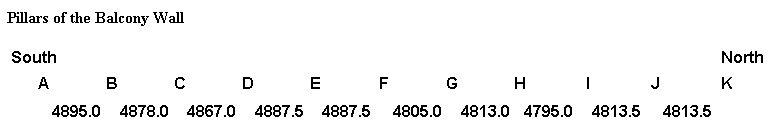
Pillars of the Balcony Wall
The above very suggestive table, shows that the ten distances hover around
four meters eighty centimeters. The average of the distances from one pillar to
another, we repeat, or 4 m. 84 cm. 5.75 mm. would have corresponded to three arm
spans, or three Lokas of the Tihuanacu of the Third Period, or a Loka of 161 cm.
3.25 mm., making a total of thirty Lokas from the center of pillar "A"
to the center of Pillar "K".
(85)
If one compares the foregoing measurements with those given in volume one, it
will be noted that the Loka shows a difference of 1 cm. 6.75 mm. The cause for
this difference of about a centimeter and a half per Loka is that to be expected
between measurements not completely exact, made in that period (more than thirty
years ago) with imperfect instruments, and the new and careful measurements
carried out with a steel compensated for temperatures.
(86) To avoid errors, the
readings are made in the following manner: The center of each pillar is marked;
the metal tape is stretched from where pillar "A" begins to the end of
pillar "K" and in this way the following result is obtained, which we
judge to be unquestionable: total length 49 m. 30 cm., with the following
figures from the center of one stone to the other.
Table: Differences from Center to Center of the Pilasters

Pillars of the Balcony Wall differences table
The distance from the center of pilaster "A" to that of
"K" is 48 m. 45 cm. 7.5 mm. which, divided by thirty normal
measurements would give the figure of 161.51 which would be the true average,
or, in other words, the "meter of Tihuanacu" of the Third Period. In
my opinion, the distances between the center of each pillar to that of the next
were regular during the period of the construction of the great wall, and the
differences of a few centimeters which they show now come from movements in the
earth, of which we have spoken before.
However, as we have pointed out, there
may exist the remote possibility that the
differences we have indicated came about intentionally for astronomic reasons, a
fact which, in our opinion, is not completely improbable. It may be that the
center of pillar "F" is not exactly the center of the balcony wall,
since the center of the latter is 24m. 65 cm. and the distance from the center
of pillar "A" to the center of pillar "F" is 24 m. 41 cm. 5
mm. and consequently the distance from the center of pillar "K" to the
center of pillar "F" is 24 m. 4 cm. Herewith we present another table
which shows the setting of the sun each thirty days toward the pillars
"but" taking the center of pillars "A" and "K" as
solstitial points, or as the maximum oscillation of the sun in its amplitude.
Since the balcony is so important by virtue of being the most monumental and
significant part of the temple, we are presenting forthwith the dimensions in
width and thickness of each pillar which forms this enormous south wall.
|
|
|
A |
B |
C |
D |
E |
F |
G |
H |
I |
J |
K |
| Width
|
885 |
1226 |
805 |
1605 |
----- |
1998 |
1150 |
1925 |
1300 |
1640 |
800 |
| Thickness
|
847 |
705 |
800 |
965 |
----- |
1910 |
1010 |
875 |
890 |
----- |
840 |
|
|
|
|
|
|
1960 |
|
|
|
|
|
|
|
|
|
|
|
1006 |
|
|
|
|
|
|
Since the wall of which these "kalasasayas" formed a part
(87) was
not concluded, as the notches indicate, it is to be supposed that on the top of
each pilaster, there was a superstructure with a little window similar to the
one still supported by the north east pillar of the "sanctissimum"
(Fig. 25).
Fig 25
through the center of which more or less the sun set every month.
As was pointed out in another part of this volume, it seems that the main level
of the interior of Kalasasaya was that of the platform of the perron, and there
possibly correspond to this level those projections or ledges shown by some
blocks or columns on the interior side of the building
(Vol. I,
Fig. 4),
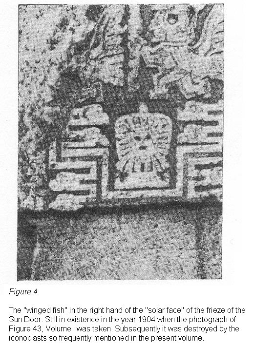
Fig 4
especially the southeast pilaster, which constitutes the corner of the east and
south walls.
As can be noted in the different outlines of the general map of the temple (Map
III) , the walls are not aligned now as they must have been in their time, nor
are the pilasters on the exact level that they had when the building was in
construction or in use, because, owing to the lack of foundations which we have
mentioned, the majority of them have settled to a greater or lesser degree.
It seems that the building that we have been calling the "sanctissimum",
must have had wholly or in part, a higher level than the interior, a fact
evident from the greater height of the "observation block", which in
turn represents at the present time the highest point of the interior in
question, as can be seen clearly in the side view B. B. of the general map of
Kalasasaya.
Something very suggestive in the interior which we are describing, is that more
or less at the level of the superior platform of the monumental perron, or
rather, at the point of altitude which in all the palace corresponds to the
level of this platform, there is found a thin layer of white clay-like sediment,
a sort of kaolin or fresh-water lime.
This is a fact which suggests two
possibilities : either that this white layer is a sediment from the lake, formed
when the waters which invaded the site of the temple dried up, or what is more
probable, the material of which this white layer is composed, was carried there
by the hand of man to form in the interior a snow white floor, well stamped
down, and one which would have given the inside of the building an extremely
attractive appearance. Perhaps it was planned as the base for a floor in mosaic
work similar to the one found upon excavating the perron (See
Fig. 23)
Fig 23
--- a
floor to be laid when the building was completely finished.
Various remnants of constructions which escaped vandalic destruction, indicate
that in ancient times there existed different levels or platforms in the
interior of the temple. This appears to be so especially in the section which
extends from the "observation block" toward the balcony wall in a
westerly direction and precisely in the region of the line where one finds the
excavation furrow opened by the Crequi de Montfort Mission in 1903 and more or
less in the center of Kalasasaya.
As we have pointed out before, there was found
in this furrow, in addition to the carved longitudinal blocks of considerable
size, a monolithic stair of two steps. This, without the least doubt, belonged
to an intermediary construction between a lower and higher level, or possibly,
at the approach to the platform toward the "observation point" of the
Third Period, the spot destined for the erection of the Sun Door.
But the most notable thing found a few feet more to the west of the
aforementioned steps and on the very intermediary line of Kalasasaya, is the
beautiful block which in the first volume we called "PEDESTAL" (Vol.
I, Pl. XV c). This, in our opinion and on the basis of its configuration, must
have served as a foundation for the rustic observation instrument which in
another section we called a "SIGHT." Its position in use was of course
the opposite of that seen in photograph No. c, which is shown clearly by the
opening for a sort of "drawer" inside, and by the typical staircase
decoration on its upper part.
(88)
Some seven meters farther on and in the same westerly direction, also almost on
the perpendicular of the building and approximately on the line of the center of
the west wall of the Second Period, there was found a gigantic slab, called by
the people the "TABLE" and a short distance away was found the
"Pedestal" (See
Fig. 20),
Fig 20
the position of both at the time of
excavation). Its purpose was, in our opinion, (because of its smooth and
slightly convex surface), to serve as a polishing stone, and for this use it was
dragged over the surfaces of the columns of the balcony wall while these were
still lying on the ground waiting to receive the final handiwork. The finishing
consisted in a polishing with water and sand, a mixture introduced between the
block and the polishing slab.
In considering the Third Period of Kalasasaya, it would also be
necessary to
refer to the repairs carried out in this period on the constructions of
the
Second. As we saw before, the men of the more developed, later periods,
took
advantage of the works of their predecessors by repairing and improving
them.
This happened not only with the idols, on which they placed ideographs
connected
with a symbology for a new and evolved theogony, but they also repaired
the
architectural works and adopted them to their needs and customs. One
can observe
this structural readjustment very clearly on the east wall of the
Kalasasaya of
the Second Period.
In this wall one sees a single technique and a
uniform state
of erosion throughout; but we also find inlayings, or, "repairs" with
classic blocks and in a very superior technique. These blocks SHOW ONLY
THE
RELATIVELY INSIGNIFICANT WEARING AWAY OF THE MATERIALS OF THE THIRD
PERIOD.
Fig.
13a
Fig 13a
shows us, on the east wall of the temple, and in a very suggestive
and clear
manner, one of these many repairs with blocks wrought in a superior
technique,
besides the technique of the inferior period.
One of these well carved
stones of
the Third Period can be seen on the left side of the large pilaster
which adorns the left side of the monumental perron. One can see there
very clearly
the enormous wearing away or erosion of this pillar and, one might say,
the
freshness of the block to its left. We believe it unnecessary to
emphasize that
the heavy erosion is not to be attributed to a material which was
softer or more
resistant to erosion.
There also belongs to the Third Period of Kalasasaya the magnificent floor
which, like a mosaic floor of a modern bath room, extends in front of the stair,
as can still be seen in the photograph of the monumental perron taken at the
beginning of 1904, immediately after this beautiful pillar was discovered by the
French Mission. (Fig. 23).
Fig 23
On the night following the excavation, a piece of
this paved work was carried off and a few days later the whole piece was taken
by the half-breed boys.
Thus the only testimony as to its existence as well as
to that of the aforementioned "PEDESTAL" and a large number of other
constructions of indescribable artistic value destroyed by them, are the
magnificent photographs taken by the author and preserved almost intact in the
archives of the Institute with which he is identified, as documentation for
future studies. (89) Possibly some of the red sandstone pillars of the north and
south walls of Kalasasaya which were very much deteriorated, were replaced in
the Third Period to preserve uniformity. This can be seen in the relatively
insignificant erosion of some pillars which, we repeat, cannot be attributed to
a more consistent material.
As the temple which is the object of our study was not completed in the Third
or Last Period of Tihuanacu, neither were there replaced in this period the
portions of the west wall which communicate with the balcony wall and which were
built in the previous period. This wall (Fig. 13b),

Fig 13b
still extant, is done with
such a crude technique that it might be compared with that of the First
Primitive Period.
Although we are considering here chiefly the monumental Temple of the Sun,
Kalasasaya, and although we shall consider it farther on, it is necessary to
note the following with regard to the balcony wall of the Third Period.
Observing the setting of the sun from more or less 50cm. beyond the west edge
of the Block, which we have decided to call the observation block, and looking
toward the pillars of the balcony wall, the priest-astronomers observed that the
sun set between pillars "K" and "A" about the solstices; as for pillars
"B" and "J" they observed that the sun set between them
about a month before and after these times. The same thing occured with pillars
"I," "H," "G," "F," "E" and
"D" more or less every month. We need not emphasize more the
importance that this information had for the determination of agricultural
seasons and connected celebrations. (Cf., in this respect, the diagram of
Fig.
2,

Fig 2
the angles of which can also be applied to the pillars of the balcony wall.)
What we have just noted is of fundamental importance for the following chapter,
which deals with the astronomical angles of Kalasasaya and the age of this
magnificent building of American man, unique in the whole world.
Many more pages could be filled in describing and studying the remains of
this construction; but those who come after him who initiated these
investigations, will study with greater care and competence all that concerning
the mysteries hidden in this most noble work --- the most important, in our
opinion, of all those which have remained in Tihuanacu and perhaps in all
America.
|
(81) The whole of the bridge (Kilometer
26) is built of the best blocks from the ruins which were previously cut to
size.
(82) An exceptional case in Tihuanacu
was that of the resident Colonel Ríos Ponce and his sons Sócrates and Carmen,
who endeavored by all means to impede the devastation and kept in a small museum
on the square of the village, a considerable quantity of notable pieces. There
also participated efficiently in this labor another citizen, a descendant of
ancient stock and a resident of the region, Mr. Nicasio Cortéz. (Cf. Fig. 31 in:
Posnansky, Antropología y sociología de las razas interandinas.)
(83) Cf. E. G. Squier: Perú. Incidents
of Travel and Exploration in the Land of the Incas, 1878, p. 217. Id. id.: Atlas
of Tschudi and Rivero, 1861, Pl. XLVI.
(84) Cf. Posnansky: Antropología y
Sociología etc. (The present arm span of the Khollas of Kollana
is something around 164 cm. and their height is about 163 cm.)
(85) This "loka" or arm span
cannot be understood to extend to all the caste of priests of that time, but was
probably limited to a single individual, the arm span of the "spiritus
rector" of the famous construction.
(86) A compensated 50 m. Chesterman
measure. (Sheffield England, No. 2531.)
(87) "Kalasasaya" means
"standing stone."
(88) In spite of our frequent
complaints in this connection, this block was broken into pieces and thus
carried away by the inhabitants of the village.
(89) Institute "Tihuanacu" de
Antropología, Etnografía y Prehistoria, Pinilla 556, La Paz, Bolivia.
|
|
|
|
Back
|
8. Astronomical Angles
|
|
Since olden times and also in our day, the question regarding the age of
Tihuanacu is one which has fascinated scholars and laymen alike. Since these
ruins were already debris in the period of the Inca Empire, capricious
commentaries and conjectures were made about their existence and the men who
built them, and especially about their age. Thus it is that until a little while
ago, the chronological aspect of Tihuanacu constituted an almost indecipherable
enigma.
Only after conceiving the idea of investigating the age of these remains of
human activity in prehistoric America, the most notable ruins which have come
down to us, and using astronomical resources to this end, has a slight ray of
light penetrated this mystery.
It is not a new thing to study the age of archaeological monuments by
astronomical means. Much before and also after the studies undertaken by the
author --- begun before 1910 --- scholars and others who laid claim to such a
title, thought of determining the age of the remains of remote periods through
the principles of astronomy. Studies of this sort have been carried out on the
monuments of Egypt, Asia, Europe and England.
Perhaps the person who carried out
this class of investigations with most skill and understanding was Sir Norman Lockyer, President of the Physical Solar Observatory of London, who, in 1909, in
his detailed work "Stonehenge and Other British Stone Monuments", supplied
the necessary foundation for the methodological investigation of the epochs in
which there were constructed the monuments of remote antiquity.
(90)
As for the
author of this present work, as we have already pointed out, his first
investigations in regard to the age of Tihuanacu, were carried out around the
year 1910. These were based on ordinary methods and reference was made to these
studies in the "Guía de Tihuanacu" which was published in the year 1912.
(91)
Then in the year 1914 and later,
after having amplified in Europe his astronomical and geodetic knowledge, he
brought forward new studies, which show evidence of a greater depth in regard to
the age of Tihuanacu.
(92) In these works, which we can call definitive, the
author employed the method of approach of the learned Sir Norman Lockyer, or
specifically, used exclusively as a basis for his calculations the change of the
obliquity of the ecliptic; in other words, the comparison of the ecliptic marked
on the Temple of the Sun of the Second and Third Periods and that of the present
time.
Through the facts expounded in the preceding chapters, it has been proven beyond
all doubt that the temple Kalasasaya was a true solar observatory located on the
astronomic meridian, and at the same time a magnificent stone calendar. For
reasons also set forth in previous chapters, it has been noted that when the
observer stands at the center of the west wall of Kalasasaya of the Second
Period, the north and south pillars of the east wall are so located that the sun
would rise at the solstices on the outer corners of these pillars. Also
approximately at the center of the building, let us say at the middle of the
monumental perron, the sun appears on the morning of the equinoxes.
Now then: if, at the solstices, one observes the sunrise without the aid of
instruments, it will be noted that it does indeed still come up on the corners
of these pillars. However, if we examine this phenomenon with precision
instruments, we note a difference of approximately eighteen angular minutes, which
represents the change in the obliquity of the ecliptic between that of the
period in which Kalasasaya was built and that which it has today.
This
difference has served as the basis for the calculation of the age of Tihuanacu.
From what has been discussed in previous chapters, there is not the least doubt
that this building was indeed built on the astronomic meridian and its angles
were the points marked exactly by the amplitude of the sun between the solstices. These few
introductory words will explain to the reader in a summary fashion how the basis
for calculating the probable age of Tihuanacu was obtained. However, in
practice, the question is not as simple as the foregoing lines might indicate.
Our colleague during the years 1928-29, Professor
Dr. Rolf Müller,
published in the "Baesler Archiv", a study which contains a part of the
work carried out jointly during the above years on the site of Kalasasaya.
(93)
Since we have carried out studies on this subject before and after the years
mentioned above, we should treat this thorny material anew in the present
chapter. We repeat that as a basis for the hypothetical calculation of the age
of Tihuanacu, or rather, for the investigation of the approximate age of these
ruins, there have been used.
THE ASTRONOMIC ANGLES SET DOWN IN DISTANT PERIODS
BY THE LEARNED PRIEST - ASTRONOMERS OF TIHUANACU IN KALASASAYA.
As we have said, the building was located, during the period of its apogee,
exactly on the astronomical meridian, and this is an orientation which it
preserves almost exactly today. In the light of what has been set down before,
it is not possible to doubt its purpose. We repeat once again that the
calculations with regard to the age of Tihuanacu are based solely and
exclusively on the difference in the obliquity of the ecliptic of the period in
which that great temple was built and that which it has today.
The calculations
based on this figure indicate a rather old age in the light of our manner of
thinking today in archaeological matters; if there were not many other
coefficients, not astronomical but of another sort, which corroborate in an
unequivocal and unquestionable manner the enormous age of Tihuanacu, and which
we shall discuss at the end of the present chapter, it would not have been worth
while to go so deeply into the astronomical studies which took more than a
quarter of a century of the writer's life.
The aforementioned difference of eighteen angular minutes noted in
Kalasasaya is the
basis for our calculations and this coefficient was applied to a curve
constituted on the basis of the formula of extrapolation recommended by
the Ephemeris Conference of Paris in the year 1911 and which is as
follows:
eps (t) = 23° 27' 8.26" - 468.44" t - 0.60" t2
+ 1.83" t3
If this curve should vary with future studies and trials in the coming
centuries of exact astronomy, then the calculation in regard to the age of Tihuanacu would also vary. However, in any event, even leaving aside the
calculation by astronomical methods, the age of Tihuanacu, a figure somewhere
beyond ten thousand years (the age of the Second and Third periods) will always
be, on the basis of geology, paleontology and anthropology, very great --- no
matter by what method or standard it is judged.
With regard to the first, or prehistoric, period of Tihuanacu, as we have
decided to call it, this is much more remote and we do not have, because of the
present state of science, any basis for establishing astronomical calculations;
rather, we can use only a geological basis for the determination of the period
in which it was built, a method which does not make it possible to express its
age in figures, but only to lay down a hypothetical affirmation of a geological
epoch and this also only within the limitations inherent to the present state of
our knowledge in this field.
(94)
In the light of the foregoing, we shall begin at once the application of
astronomical science to the discovery of the approximate age of Tihuanacu, by
means of the calculation of the age of the Temple of the Sun of Kalasasaya. In
order to know the difference in the obliquity of the ecliptic of that time, and
today, it would be necessary to know in the first place, how great is the
amplitude of the sun marked on this temple and other data which we shall
enumerate at once.
1. The total length of Kalasasaya from east to west without the balcony wall
is: 128 m. 74 cm.
2. The total width from north to south is: 118 m. 26 cm.
3. The index of length-width is: 91
4. The average of our many observations of the angle of solar amplitude
established by the priest - astronomers in the Kalasasaya of the second period
is: 49° 15'.
5. The average of our observations with those of Professors
Becker, Arnold Kohlschütter and Rolf Müller
(95) of the German
Astronomical Mission, is: 49° 22' 42".
6. The amplitude of the sun between the two solstices in 1930 in Tihuanacu,
which is located in a latitude of 16° 34' 54", is 49° 4' 2".
7. Taking into account the present false horizon of 2° 47' in the north and
of 16' in the south, as also the refraction, in this case the amplitude is 49°
59' 6".
8. The difference between the amplitude marked in the Sun Temple Kalasasaya
and the amplitude in 1930 is 36' 24".
9. The obliquity of the ecliptic in 1930 was 23° 27'.
10. The obliquity of the ecliptic during the construction of the Kalasasaya
Temple was 23° 8' 48".
This figure would be the base to apply it in the curve which is constructed,
according to the formula of the International Conference of Ephemerids in Paris
in 1911, which is as follows:
11. eps (t) = 23° 27' 8.26" - 468.44" t - 0.60" t2
+ 1.83" t3 (96)
The curve which is constructed on the base of the previous formula is the one
which follows in
Fig. 28.
12. Then applying this figure of 23° 8' 48" to the curve of
Fig. 28.
13. This value touches the curve where the ordinate-axis and the
abscissa-axis cross each other.
14. Which is on the point of 15,000 years B.C.
This figure would constitute the probable age of Tihuanacu in the
"Second Period" and some what less in the "Third Period."
To those who wish to know what our working companion,
Dr. Rolf Müller, has
published, we recommend his article in the "Baessler
Archiv",
1931.(97)
The scope of the present book does not allow us to enter into greater
detail
concerning the opinions of Professor Müller; but those who have a
special interest in the calculations and methods of that scholar, can
consult the work cited
in note No. 94 and will be able to form an exact opinion of our
studies. These
in the main have proceeded in a parallel fashion, since for more than
two years
we have discussed the different "working hypotheses".
And now to return to the method which the priest-astronomers of
Tihuanacu may
have used, we should call attention to an extremely important fact. A
few years
ago upon the occasion of the visit of the Prince of Wales, an
automobile road
was built to cross the ruins; this road passed over the point where the
aforementioned priests must have made their observations, or the center
of the west
wall of the Second Period.
Precisely here was discovered the beginnings
or base
of a platform which in its time must have had a considerable height,
equal
perhaps to that of the upper notches of the balcony wall of the Third
Period
from which the priest-astronomers presumably made their
observations. If
the aforementioned elevations in the east which covered the true
horizon and
which were taken into account by Professor Müller in his calculations,
existed
at the time of the Second Period, the angle of altitude from this point
of
higher elevation would also have changed in the observations.
Another
fact which
must be taken into account is that when at the present time during the
summer
solstice one observes the sun toward the south pillar of the east wall,
the
slopes of the hill Akapana cross his line of vision (as is seen in the
small
accompanying drawing,
(Fig. 29)

Fig 29
which can be said to obstruct the view
when the
sun rises.
But this is the case only at the present time, because the
terraces
of the artificial hill of Akapana which formerly were supported by
retaining
walls, are crumbled. It is to be noted that at that time the line of
sight passed perfectly through the reentrant angle of the first terrace
and that was especially the case when the observation point at the
center of the
wall of the Second Period was at a height, as in fact it was, as is
indicated by
the above mentioned base which was discovered.
Moreover, on the basis
of the
geological studies mentioned in one of the preceding chapters, it is
presumed
that the horizon in the east was, if not completely free, at least
lower than at
the present time. And we repeat that before they would have ventured to
construct a building of the magnitude of Kalasasaya, they had, in
another place
where there was a free horizon, a small observatory where they carried
out their
original observations and from where they would have been able to bring
the
angle of amplitude for the final Kalasasaya, (Fig. 30).

Fig 30
Since we have exhausted the subject of the astronomical angles of the Second
Period of Tihuanacu, it is necessary to consider the angles of the construction
which is within the Kalasasaya of the Third Period.
As it has been demonstrated with abundant material in the preceding
paragraphs that in the interior of Kalasasaya there exist remains of relatively
modern constructions which, with the present balcony wall, belong to the Third
and Last Period of Tihuanacu, it is absolutely necessary to consider the
astronomical angles which it contains.
We have seen before, that in the interior of the temple another small
Kalasasaya exists in the form of a little subterranean shrine (See Map. Ill)
with stair case designed walls in its interior, as best can be judged from the
scant extant remains available when these ruins were first studied at the end of
1903. Even today, after a devastation of forty years, some remains are still
found, although they are not as abundant as in that period. The most important
thing in this little shrine, which we have decided to call "sanctum
sanctorum", is, in the first place, a block of trachyte which now is split,
located in the most prominent part of the place and which until now we have
called "observation block", (fig 26)
Fig 26
This in its time, as is
indicated by the notches still to be seen on its surface, had a superstructure
on which, in our opinion, there was to be placed the block which at the present
time we call the Sun Door. This place, then, is the most elevated one in the
interior of the temple and without doubt designates the most important place of
the "sanctum sanctorum".
The accompanying figure (No. 25) shows its
position and the marks chiseled by us on its surface during our studies in the
year 1928. This we published in a communication sent to the Twenty-third
International Convention of Americanists, meeting in New York City that same
year. Observing from this block the corner stone to the north
(Fig. 25)
Fig 25
which
still exists in the old east wall, one sees that the sun rises on it during the
winter solstice (June 22).
By reconstructing on the map the walls of the small temple on the basis of what
was still extant in the year 1903, one obtained an angle of amplitude of 49°
16'. But the most interesting thing is that if one observes, at a
distance of five meters toward the west of the aforementioned observation block,
where there are still remains or a construction, the centers of the Kalasasayas
(98) of the west balcony wall, one notes that the sun sets in the center of the
pillars "A" and "K" at the solstices and on the dates noted
on the accompanying diagram.
This is an important fact and one which leads to
the conclusion that this structure which we have called the "sanctum
sanctorum" was the solar observatory of the Third Period of Tihuanacu. The
astronomical angles are, with some slight difference, almost the same as those
of the Kalasasaya of the Second Period.
This is the case because the length of the "sanctum banctorum", taking
as a basis the north corner block of the no longer extant east wall and the
block of trachyte which we have been calling "observation block", is
72.1 and the width is 64.2. By means of a simple trigonometric operation we then
get the angle 24° 38'.
On the basis of the above length and width of the "sanctum sanctorum",
the index of the latter is 89 instead of the 91 of the exterior building of the
Second Period. From this fact it can be presumed that no great space of time
intervened between one period and the other.
In the interest of future verifications which may follow those already carried
out, we give in
Fig. 31
Fig 31
the drawing of the observation block with the marks
which we engraved on it during our researches. Also, in
Fig. 24,
Fig 24
there is
reproduced a drawing of the perron with the marks which we chiseled on its
platform.
We have not the least doubt that some day our measurements
(99) will be
controlled by competent geodesists or astronomers and possibly certain errors or omissions will be
rectified, which escaped us through faulty personal judgments or for other
reasons.
In spite of this, we are convinced that the way has been opened for the
study of the stone calendar and the foundations laid for the calculation of the
age of Tihuanacu. We feel, also, that our observations will be of help to those
who in the future, establish themselves in the region under study, and having
the necessary time and resources, face the study in all its amplitude,
correcting errors which we may have made, and thus shedding greater light on the
purposes for which that magnificent temple and stone calendar was constructed
and on the age of these notable ruins.
Now that we have considered in this chapter the hypothetical age of Tihuanacu,
it will be necessary to consider also other aspects which, although not of an
astronomical nature, corroborate and reinforce further the presumption of the
extremely old age of the metropolis of American man. They are the following:
1. It is evident beyond a doubt that the inhabitants of Tihuanacu knew
animals now extinct, which they reproduced faithfully by stylizing them on their
ceramics and other plastic works. This fauna possibly disappeared at the end of
the last period of glaciation on the Altiplano, as is shown by the
alluvial strata.
2. Certain human crania found in the deepest strata of Tihuanacu, especially
one which is located in the Museo Tihuanacu of La Paz (marked No. 1) and
reproduced on the corresponding plate of Vol. Ill, are completely fossilized
(100) and show primitive signs, particularly those which were found in a sort of
Löss and in the reddish clay of that region.
3. One of the decisive proofs of the age of the man of Tihuanacu, is the
subterranean dwelling. In that age, especially in the first period, they did not
yet build houses; their temples were semi-subterranean buildings. This primitive
custom still persists in the Second and Third Periods, in which even those of
the ruling class who lived on the island surrounded by the moat, lived in tiny
dwellings where they remained and slept in a squatting position. Up to this time
four of these have been found in almost intact form
(101) and before our studies two more were found.
There is no doubt but that if sensible
excavations were carried out, various others would be discovered. It is not
possible to hold to the belief that the primitive American man who until then
lived in caverns and subterranean caves, would come out of them and immediately
construct his dwellings on the ground. It was necessary and it is logical to
suppose that there would be a period of transition between the two forms of
dwelling and this is seen in the completely subterranean dwelling that we have
in Tihuanacu. An identical evolution is witnessed in centers of archaic
civilization in Peru, especially in Katoc and in Chavin de Huantar.
4. Another of the factors which influenced human development in Tihuanacu is
the climate. Had this metropolis been built at an elevation above sea level like
that found today, it would have had an inclement climate and one unsuitable for
human life, as is seen in that of the present time, with its atmospheric
phenomena so injurious to the development of agriculture and cattle raising.
Under such circumstances it would never have attained the extremely dense
population that it had in past epochs. The climatical cingulum has changed from
the period of the apogee of this civilization to the present time. The northern
part rose and the southern part suffered a great fall. We consider this matter
in greater detail in another of our works.
(102)
5. The fauna and flora changed radically from the epoch of splendor to our
time. This can be proven by the remains of marine fauna found at the present
time in Lake Titicaca and in the clays of the subsoil of Tihuanacu.
(103)
6. It is unquestionable that the great Andean lake formed by the
meltings of
a glaciation existed in the Second and Third Periods, and that in the previous
period this lake was very small --- much smaller that at the present time. On
its banks there exist man-made constructions which have been revealed by the
enormous and final fall of the lake.
7. The erosion of the blocks of the First Period which are exclusively of red
sandstone and of their very primitive sculptures on a calcareous volcanic tufa,
show an abrasion extending over thousands of years. This is the case although
perhaps also for thousands of years they lay covered by alluvial mud which later, little by little, was washed
away by the torrential rains which have for the most part revealed them. Even
the blocks of extremely hard andesitic lava of the Second Period, especially
those of the east facade of Kalasasaya
(Fig. 13),
Fig 13
show a considerable wearing
away from erosion, particularly the two monolithic blocks at the sides of the
perron (Fig. 23),
Fig 23
even though they were covered with earth until the year 1903.
The blocks of red sandstone of the external north and south walls of Kalasasaya,
which when they were constructed, had a regular form, were rather well carved
and covered with ideosymbolic inscriptions on the inside, which is shown by a
fragment saved by chance, (Figs. 21 and 21a).
Fig 21
Now these have the appearance of
rough blocks recently extracted from the quarries, some even having decayed or
disappeared or there being only scant remains of them.
All these facts make evident the enormous lapse of time which separates us from
the period in which they were erected and carved. It seems, moreover, that a
certain number of them were reconstructed and renovated during the Third Period,
a period in which use was made of the works of former times.
Erosion is quite evident in the ruins of
Puma-Punku, so-called today, but which
in our opinion constituted in that epoch the Temple of the Moon. There one can
study clearly "by periods" the wearing away due to erosion.
There one
sees, for example, the monumental south platform of the First Period
(104)
which
shows such erosion that it gives the appearance of a rough stone just
removed
from the quarry, since the details of the staircase embossments are
almost
completely erased; the other platform to the north shows an abrasion
not yet so
complete. Between these platforms one finds two more which, in our
opinion, come
from the Second and Third Periods. One of these is apparently
completely
finished and the other to the south, formerly set on a notch in the
interior,
shows the relief work scarcely begun, (See the corresponding chapter
which deals
with Puma-Punku) or, the "seats" have scarcely been sketched in.
One
can also see clearly the effects of the successive erosions and,
moreover, the
repairs carried out during the Third Period by means of metallic
retaining bolts or a kind of clamp. There are many probabilities for
believing that Puma-Punku was almost completely covered by a dumping of
alluvia
which was swept away in part by very old searchings dating from much
before the
Conquest. Later, when the inhabitants of the Peninsula came to the Altiplano,
new excavations in search of hidden treasure were carried out on a large
scale.
Still later, in the period in which these ruins served as a quarry for
the construction of the church in the modern village of Tihuanacu, the rest of
the alluvia which still covered the ruins was removed. The treasure hunters even
searched beneath the immense blocks, such was the burning desire to find wealth.
The bronze of the great bolts with which the masses of rock were joined was used
in the casting of bells for the same church.
Owing then to this protective layer which covered the ruins of
Puma-Punku, these
suffered relatively little wearing away, as we note in some blocks. A gigantic
image of red sandstone completely covered with inscriptions was found in the
little temple of the First Period; this was a primitive rustic idol like those
found near it, and had been retouched, one would say, during the Second, or more
probably, during the Third Period. The degree of erosion in Tihuanacu is in
proportion to the time that the ruins were exposed to the inclemency of the
weather.
Thus, for example, the idols on the line to the south side have again
taken on the appearance of rough stone; only the largest, which except for the
face was covered with a layer of alluvium still preserves its magnificent
embossments and carvings. The Sun Door which was found lying on its face on the
ground, has been preserved in wonderful condition with all its inscriptions; but
its back, and especially the end exposed to the adverse atmospheric conditions,
shows an enormous wearing away. It should be pointed out that the block from
which this notable monument was carved, is composed of andesitic hornblende,
vitreous and very hard lava, which, polished as it was in that period, required
several thousands of years to,wear away in the form in which we see it today.
(See the reconstructed figure,
Fig. 11.)
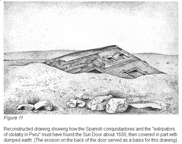
Fig 11
Many pages could be written to enumerate
the destructive effects of erosion on the blocks of Tihuanacu which,
notwithstanding the quality of the material of which they were composed, and the
period during which they were protected from the exterior elements, suffered the
effects of time in an intense fashion.
8. The glacial Andean lake, or as d'Orbigny calls it, the "inner
sea", certainly reached in the Second Period and unquestionably in the
Third, as far as the edges of the monuments of Tihuanacu. This assertion is
proven by the many hydraulic works, such as wharves, canals, and especially the
spillway by which the step-formed canal was drained.
This spillway constituted
the outlet for the artificial lake located on the surface of the pukara Akapana;
it drained into the moat which, communicating with the lake, formed an island in
the most sacred part of the temple. At the present time this spillway is found
under the plain, crossing the south retaining wall of Akapana. In the course of
the excavations carried out by the Crequi de Montfort Mission, the spillway was
visible for a few days; then fortunately slides of earth and the rains covered
it again with a protective layer which saved it for the benefit of future
studies. (See Vol. I. PI. XIII, Fig. b.)
Other structures
Figs. 32 and 32a)


Figs 32 and 32a
which presumably belong also to the First or
Prehistoric Period of Tihuanacu because of their special and primitive
architecture, are the monuments found on a little island in the lake which is
today called Hakonts Palayani. This is the prolongation of Lake Titicaca in the
overflower. These monuments give evidence of a most remote age which cannot be
expressed in figures and although they are not found in Tihuanacu itself, but at
some 25 km. in a straight line from this metropolis, it is necessary to study
them as an integral part of the latter place when we consider the age of the
Andean ruins and the activities of primitive American man.
These monuments were
under the surface of the waters some four hundred years ago, when Spanish feet
first trod the Altiplano. Even today during periods of intense rain ---
in periods of minimum sun spots --- they are covered with water and can not be
distinguished from the lake which, we must not forget, is nothing more than the
remains of the great glacial lake which, during the flowering of Tihuanacu,
reached the gates of this metropolis. In that period, consequently, these ruins
(105) were some 34 m. 73 cm. underneath the waters. When we consider from the
geological point of view the withdrawal of this liquid mass, from that period until our day, when the lake is
20 km. distant from the ruins, and more or less 34.73 m. below the once busy
wharves of Tihuanacu, we have another bit of chronological data which furnishes
a conclusive illustration in regard to the age of the metropolis.
This analysis can be summarized as follows: the lake, reaching as it did in the
Third Period to the edge of the great metropolis, had a height which would
correspond at the present time to some 3,839 m. above sea level, as is shown
unquestionably by the still existing hydraulic works of Tihuanacu. This estimate
takes into account the periodic fluctuations which occur in this great lagoon.
(106)
The Altiplano at the time of Tihuanacu's height did not show the
inclination toward the south
(107) which it now has, and the lake then extended
over all the land which now constitutes that region; that is, over all the
enormous basin enclosed by the Andes.
Supposing that the high plain had had, in
the period of the splendor of Tihuanacu, the inclination to the south that it
has now, a barrier several hundred meters high would have been necessary to
prevent the lake from draining toward the south, or toward what now constitutes
the Argentine Republic.
This being the case, the part which is today the section
of Oruro would have been under a layer of water of some 155 m. However, since
the strand lines which show what at one time constituted the edge of the great
Lake Titicaca, are 44 m. above the level of the plain of Oruro (Fig. 33) and
only 52 m. above the present Lake Poopó, it is unquestionable that the Altiplano
inclined, either in a violent manner or through successive modifications,
undergoing a considerable fall toward the south and southwest and also probably
toward the southeast. In the course of this process its waters flowed in these
directions and this is a phenomenon which would have endured in the memory of
all the generations, had it taken place during a relatively recent period; in
such a case the signs of the draining would still be visible and would not have
disappeared as they have.
9. A southern inclination of the continent of such a sort could occur only as
the result of geotectonic factors, caused in turn by the cessation of the effects of a great pressure
(ice) on that part made up today of the Altiplano.
10. By analogy it is possible to determine that the last glacial period took
place in the Southern Hemisphere at the same time as in the Northern, since
there is no atmospheric nor cosmic factor that we have been able to discover,
that could have prevented it.
11. The true cause of the last glacial epoch, as well as that of the previous
ones, is still doubtful, but the conclusions from a majority of studies indicate
that it occurred simultaneously in both hemispheres, EXCEPT IN THE LOW LEVEL
EQUATORIAL REGIONS. (107) The chronology of the glacial period in the north of
Europe has been studied and determined exactly, thanks to the brilliant
investigations of Professor Gerard de Geer, and especially because of his
investigations of the stratifications of glacial clays (Varven) undertaken in
Sweden. The latter gave the figure of 6,900 years B. C. for the end of the
glacial period and 12,600 years B. C. for the end of the Danish glacial period.
(108)
Since the most southern glacial period of Sweden, or, alongside of Central
Europe, took place some 13,000 to 15,000 years ago, by analogy one can judge
that, in the same latitudes, and at the same levels above the sea, in both North
and South America, the same thing occurred.
However, in certain parts of the South American continent this climatic
phenomenon took place in a different way; this was particularly true in those
regions which in a recent geological period already had a considerable elevation
above sea level, as is the case in that great expanse of territories, tablelands
and lakes enclosed between the two Andean mountain ranges—the Cordillera
Marítima and the Cordillera Real, and which had already risen to a
considerable height since the Tertiary period and were, moreover, relatively
near the equator.
The Bolivian Altiplano, for example, the prehistoric seat of the greatest culture of the Americas, which, as we shall prove
farther on, did not have the great height above sea level that it has today, did
not because of its proximity to the equator, undergo a glacial period as long as
that in the territories of present-day Argentina. For this reason, it harbored
human cultures much before other sections or in a period when the Argentinian
territories were still covered by the continental ice which at the present
geological moment and for some thousands of years more, has withdrawn to the
Antarctic.
It has been proven, by the studies and conclusions of celebrated authorities in
modern geology and geography, especially by the monumental works of Professor
Albrecht Penck, former Director and Founder of the Oceanographic Institute of
Berlin, that the continental ices of Europe exerted an enormous pressure on
those lands, over which they lay. As a result these lands descended and
after the glacial masses had melted or retired from those zones, freed of their
weight the territories rose again.
This same phenomenon of the rising of territories --- after being freed of a
covering or glacial weight --- doubtless took place on the Altiplano of
Bolivia in a much more intense form than in other parts of the world, due to
the fact that it was located at a considerable height and relatively near the
equator.
Because of this greater height above sea level its climate, after the
Tertiary period, was never torrid; and because of this same elevation ---
naturally not as pronounced as that of the present time --- and owing to the
proximity to the equator, that glacial period lasted there much less time as
compared with other lands of the South; thus there could develop there, in a
relatively remote period (First Period of Tihuanacu) great human
cultures, which probably did not yet exist in such a grade of development on
other parts of our planet.
When the great Andean lake was formed at the end of the last glacial period, the
following phenomenon occured: the ices melted first in those zones relatively
near the equator and the enormous pressure or weight which rested on the
mountain ranges and high table lands of the Andean regions disappeared very
gradually.
Then those territories began to rise slowly also, while the zones to
the south, like those of Argentina, because of their distance from the equator,
still supported for a long time an
enormous covering of ice which held these regions, in various places, still
submerged under the ocean, regions designated today as pampa formation. In other
zones located farther to the north, a little above sea level, the regions
remained in a static condition.
Little by little, or rather, century by century, the northern part of the
present Altiplano and mountain ranges rose as a result of the cessation of the
aforementioned weight of the ice, and it was then that there was produced an
initial inclination which drained the first great glacial lake. Afterwards there
occurred that other inclination --- so enigmatic a short time ago --- of the last
post-glacial lake or Lake Tihuanacu the shore line of which a we have
pointed out, we followed on one of our last expeditions for 400 kilometers.
There have always existed in the inter-Andean regions extensive salt lakes.
These were naturally of lower level and existed much before the last glaciation.
They no doubt had their origin in the Tertiary period when the continent emerged
for the first time, suspending waters of the ocean and forming the mountain
ranges. From that distant period there also comes the ichthyic marine fauna of
these waters, the descendants of which still live, completely degenerated, in
Lake Titicaca and Lake Poopó.
In the light of this discussion it is very difficult to think that the culture
of man on the Altiplano and the construction
of his magnificent metropolis belongs to a relatively recent epoch.
12. One of the proofs with which
we can also reinforce our assertion concerning the enormous age of Tihuanacu, is
that in the folklore of the Altiplano nothing is related of traditions
which allude even remotely to the origin and object of that magnificent
metropolis. It is unquestionable that a huge culture like that of Tihuanacu would
have left an imperishable recollection in the minds of the men who inhabited this part of the Andes, if it had been
evolved in a relatively
recent period.
But it did not happen thus; no memory has remained of that epoch;
already at the time of the
Conquest, the Indians, when asked regarding the age of Tihuanacu, replied that
those monuments
had
always been there or that they had appeared on the dawn of a very remote day or
that they were constructed by a race of giants, called "Huaris",
before Chamak-pacha. This matter of Chamak-pacha in Aymara or Purin-pacha in
Keshua is extremely interesting.
Both words mean "period of darkness."
This tradition extends not only to South America but also to the most northerly
part of North America. According to it reference is obviously made to a glacial
epoch in which the sun lacked thermic power or was not so visible and as a
result did not benefit human beings with its life-giving rays. It would involve
a long discussion to enter into details about this aspect and we wish only to
touch on it lightly because of its great interest.
(109)
13. Another proof which we can bring to bear, and with greater reason, to
prove the very great age of the culture of Tihuanacu, is that connected with the
great diffusion attained over the whole continent by the famous "Staircase
Sign." This sign, it can be asserted, originated in Tihuanacu and
represents the fundamental cosmological idea
(110) as well as the worship of
Mother Earth (Pacha-mama).
This sacred symbol, like the cross of the Redeemer in
Christian religion, spread from Tierra del Fuego to Alaska. It has now lost its
meaning owing to the present cultural state of native population. Because of it
one can say that in every place where the culture of this continent has
appeared, there can be noted a substratal Tihuanacu.
14. SUMMARY: If one wished to collect all of the ideas about the great age of
the civilization of Tihuanacu with the attendant bases and proofs, one could
fill a whole book. But we feel certain that in the preceding paragraphs we have
outlined in a clear and synthetic form, the nature of such proofs, which are: astronomical, anthropological,
paleontological, geological, petrographic and sociological.
By consulting the literature cited in the notes accompanying the text, complete
and precise information may be had about all the subjects which have been
treated very hastily in the present chapter.
|
(90) Unfortunately, we were not
familiar with this work when we made our first efforts to determine the age of
Tihuanacu, and finally in 1914, Professor F. S. Archenhold, Director of
the Observatory of Treptow (Berlin) called our attention to this notable
publication.
(91) This guidebook was the
continuation of our still ordinary studies on Tihuanacu, made known before the
Fourth Scientific Congress (First Pan-American Congress) which was held in 1908
in Santiago de Chile and in the Anales (Vol. XI) where the studies were
published: "Studies of the Third Section, Natural, Anthropological and
Ethnological Sciences" (Vol. I, pp. 1-142). Since the Guia de Tihuanacu,
Islas del Sol, etc. was published in the absence, of the author, he was
unable to correct the proofs, and it came out with several mutilated lines in
the section dealing with the age of Tihuanacu. This fact gave rise to polemics
and malicious interpretations. Cf. Posnansky: "Así habla la Esfinge
Indiana", La Paz, 1926.
(92) Cf. "La edad de
Tihuanacu",
Boletín de la Sociedad Geográfica de La Paz, 1918.
(93) Der Sonnentempel in den Ruinen
von Tihuanacu. Versucb einer astronomischen Allersbestimmung, Berlin, Dietrich
Reimer, 1931.
(94) Cf. Posnansky, El pasado
prehistórico del Gran Perú. Chap. IV: "El descubrimiento de las ruinas de
Chuju Perkha y su Importancia para el advenimiento del hombre en América",
pp. 47-53. La Paz, Bolivia, Editorial "Instituto Tihuanacu", 1940.
(95) Becker of the Specula Vaticana,
Kohlschütter of the Astronomical Observatory of Bonn, Müller of the
Astronomical Observatory of Potsdam. Professor H. Ludendorff also carried out
studies with us in Tihuanacu.
(96) Cf. p. 50 of Das Weltall, 24 Jhrg.
2 Heft, November, 1924, in the article: "Kulturvorgeschichtliches u. die
astronomische Bedeutung des Sonnentempels v. Tihuanacu in Bolivien". (With
nine illustrations).
(97) With the preceding data our
preliminary statements have been rectified; they are: (1) In the Guía de
Tihuanacu, 1912; (2) In the Boletín de la Sodedad Geográfica de La Paz, 1918;
(3) In the Weltall, No. 24, 1924; (4) In the lecture given at The Hague
and published in the Andes del Congreso International de Americanistas, 1924;
(5) In "Notas cronológicas de Tihuanacu" in Proceedings of the
Twenty-third International Congress of Americanists, Sept., 1928, New York,
1931; (6) In the works which we carried out in company with Professor Rudolf
Miiller during the years 1928-29 and which he published in the Baesler Archiv,
1931.
(98) An Aymara expression which means
"standing stones."
(99) The maps in question are preserved
in the "Institute Tihuanacu de Antropología, Etnología y
Prehistoria",
La Paz, Miraflores, Calle Pinilla 556, founded by the author in the year 1914
with his own funds and without the aid of governments, institutions, or private
individuals.
(100) We repeat what was stated on p.
29 of our work El Pasado Prebistórico del Gran Perú to the effect that
fossilization is not an evident indication of very great age.
(101) Cf. Posnansky, Templos y
viviendas, 1921, p. 30, Fig. 3 and id., id., infra in the
corresponding chapter of the present work.
(102) Cf. id., "La remoción
del cíngulo climatérico" in Proceedings of the Twenty-third
International Congress of Americanists, Sept., 1928, New York.
(103) Cf. Figs. 3 and 5 of Vol. I.
(104) lt is known that this platform,
as well as the temple itself, were started in the First Period, because they
still preserve the orientation of that primitive period, the same as that of the
primitive temple and Pukara of Akapana.
(105) Cf. Posnansky, Antropología y
sociología, 2nd ed. 1938, pp. 106-112.
(106) Cf. id., El pasado
prehistórico del Gran Perú, Fig. 21: Drawing showing the fluctuations of
Lake Titicaca from 1914 to 1940; also Boletines de la Sociedad Geográfica de
La Paz, Nos. 64 and 66.
(107) Id., "La remoción del
cíngulo climatérico etc.", loc. cit.
(108) Cf. De Geer Gerard, Om
moejlighten of att injoera en Kronologie foer instiden Geol Foeren 6, 1882;
id., Om de definitive foerbindelsen nellan den svenska tidskalen senglaciala
och postglaciala del Geol. joeren, 46, 1924.
(109) The tradition of the "Huaris",
of Poma de Ayala and others, as the forebears of the man of culture is
extremely old among the inhabitants of the mountain range of the continent. In
our opinion, it has its origin in the discovery of gigantic bones of extinct
animal species by the Indians, in places where the currents of water revealed
them. This supposition is supported even further by the meaning of the word
"Huari" or "Wari" which means in Keshua "Cameloidea"
(vicuña) Phelipe Guaman Poma de Ayala, in his Crónica y buert gobierno (end
of the sixteenth century), when he considers the primitive ancestors of the
Indians, alludes to the "Pakarimoj-runa" and "Wari-runa." .
(110) Cf. Posnansky, El signo
escalonado, Berlin; 1912; El pasado prehistórico del Gran Perú, La Paz,
1940; "Es o no oriundo el hombre lamericano en América? Puntos de contacto
lingüístico y dogmático en las Américas", in Anales del
Vigésimo-séptimo Congreso International de Americanistas, (Mexico City, 1939)
Vol. I, pp. 98-118. See also Introduction to American Indian Art. Part. II.
Kenneth M. Chapman. Indian Pottery, pág. 8, Introduction to American Indian Art
by John Sloan and Oliver La Farge, Part I. Plate XVI.
|
|
|
|
Back |
J. J. Augustin Publisher, New York, 1945
Tihuanacu, the Cradle of American Man.
by Arthur Posnansky
Volume II
Chapter II
The Temple of the Sun Kalasasaya, an "Inti Huatana". Astronomical Science in Tihuanacu
· A. The Beginning of Studies in Tihuanacu
· B. Architecnographical Introduction
· C. The Object of the Building Kalasasaya
· D. The Two Different Periods in the Construction of Kalasasaya
· E. The Astronomic Science of Tihuanacu. How Kalasasaya was Built to be Used as a Stone Almanac
· F. The Approach to Kalasasaya. The Monumental Perron
· G. Kalasasaya of the Third Period

atlantisbolivia.org
|


