
which measures from Google earth 330ft wide, so in Sumerian units this feature would be 200 cubits wide
This page is in process of development as a result of correspondence received from Heitor Bahiense, a Software Engineer in Palm Beach, Florida. Heitor after studying the Nazca lines and formations put forward the proposal that they are part of a worldmap and is deveoping a website geekglyph which explains all of this.
I will leave the map and constellations explanation to Heitor as his correspondence sparked me an interest to look at Nazca to see if they used standard units of measurements in setting out the geoglyphs.
The first problem looking at Nazca, is where is it? And how to find all those various different patterns and drawings? A major problem of Google earth is you can see extremely well individual features when highly zoomed in, but you lose the overall broad, mental picture when zoomed out and many features become difficult to find because people do not always post co-ordinates. Wikipedia for example gives general co-ordinates 14°43'00"S 75°08'00"W for Nazca and although it features some close up photos of individual glyphs, it does not give coordinates for these. The geekglyph site hopes to rectify this by allowing you to click on a geoglyph symbol and zoom in on it on Google earth.Meanwhile, first of all, other ancient sites studied in Mexico, Peru and Bolivia suggest that Ancient America used a system of measurement base on "Sumerian" cubits, feet and yards together with "Egyptian" cubits which were part of a universal system which may have originated in the Americas. Briefly, the "Sumerian" cubit was 24/25ths of the "Egyptian" cubit and basic units were
shusi = 0.66"
foot = 13.2"
cubit = 19.8"
yard = 33.0"
double yard = 66.0"
rod = 16.5 English feet (15 Sumerian feet)
stade = 100 sumerian cubits (165 English feet)
2 x stade = 200 cubits (330 English feet)
4 x stade =400 cubits (660 English feet or one furlong)
Egyptian royal cubit 20.625"
Tiwanaku cubit 20.17" width of some measured ducts.
Using the Google earth coordinates obtained from Wikipedia, I zoomed in on Nazca and the first glyph that caught my eye was one of the "landing strip" style
which measures from Google earth 330ft wide, so in Sumerian units this feature would be 200 cubits wide
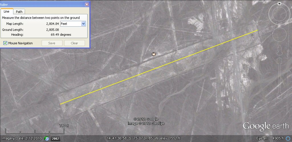
the length of the same feature is about 2804ft which in Sumerian units would be 1700 cubits.
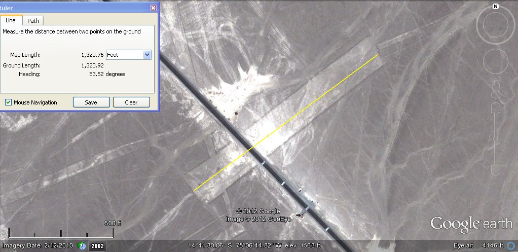
the next feature I measured had a length of about 1320ft which is 1200 sumerian feet or 800 cubits

next a glyph which measures about 198ft or 120 cubits in one direction...
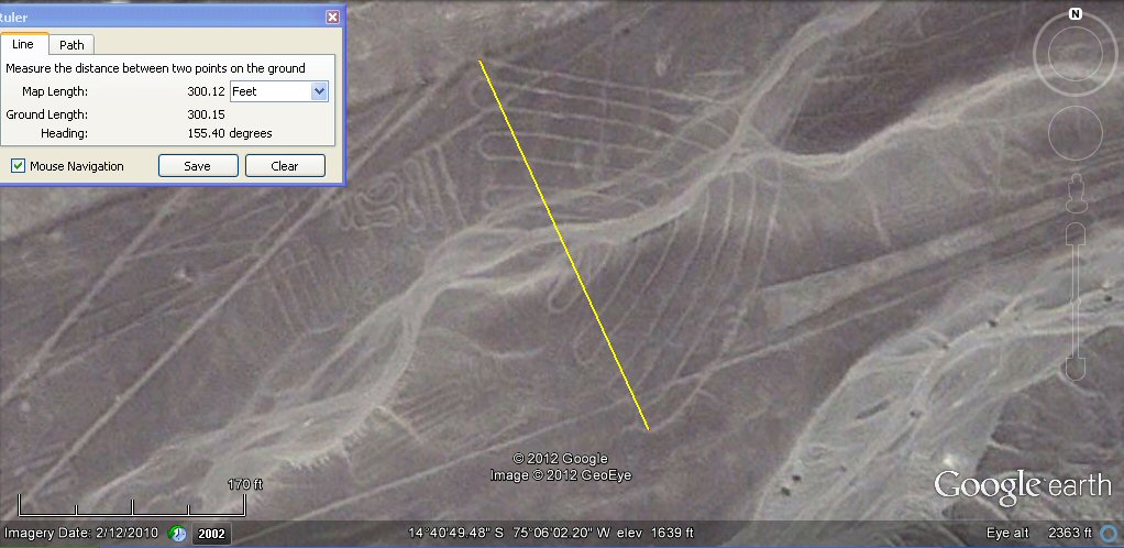
and about 300ft or 297ft which would be 180 cubits in the other direction...

one of the "wings" measures 16.5ft which is a standard rod of 10 cubits...

and the other wing measures 20ft or 19.8ft which is 12 cubits...
With Google earth at this scale, it is possible to slightly juggle the measurement figure
to get it to come out as a favourable number, on the other hand it measures in increments, so 20.7ft in the above photo
is a close approximation given the scale of the photo etc and of course, what standard of setting out and drawing was used in the first place?
Sufficient it seems to determine the underlaying measurement system, so it remains now to identify other glyphs
(to be continued) and have a look for further consistency.

this spiral measures 110ft or 100 Sumerian feet from the central loop.

the diameter of the spiral is about 75 metres, making it about 150 Sumerian cubits.
An interesting page by Michael Palomino with a collection of maps

Nazca map helps locate the glyphs, but still lacks latitude and longitude.

Many of the rectangular or trapezoid formations reminded me of agricultural clearances.
I also noticed that each end of the trapezoids appear to have what may be circular wells.
In the example above, approx, 1,000 Sumerian feet apart.

Another example of possible wells at each end of the trapezoid, in this instance 1400 cubits apart.

Another example of possible wells this time 1600 cubits apart.

Another example of possible wells at each end of the trapezoids.

Another example of possible wells at each end of the trapezoids.

Another example of possible wells at each end of the trapezoids, this time 660ft i.e. 400 cubits apart.

The glyphs and straight lines may have had varied purposes but some trapezoids seem to
be interconnected by narrow channels as if they at one time conducted surface water from the wells.

Note this posible well on one of the channels just north of the spider.
I have read previously about underground channels or conduits at Nazca, and an interesting page on Nazca channels mentions the use of wells as well as the undergound channels, so perhaps the above are examples of these wells which relate to the trapezoidal clearances, the wells are also similar to those which exist on the Bolivian Altiplano which is also rumoured to contain underground channels and is also criss-crossed in places by innumerable ancient now abandoned cultivations amd canals.
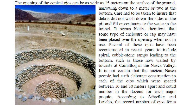
Example of well or "ojo" from the above report.
Underground water channels are also found in ancient Persia where they are known as Qanats. With this system, water is conducted beneath the plain using artifically constructed channels and emerges via wells to irrigate cultivable land using surface channels. In some areas the surface today is barren and bare stones, but columns of stones cleared from the landscape illustrate (in Bolivia) how large areas once supported thriving and industrious agricultural communities.
illustration of construction of qanat from Scientific American.
Interestingly, the writer of the Qanat article says
"Written records leave little doubt that ancient Iran (Persia) was the birthplace of the qanat.
As early as the 7th century BC, the Assyrian king Sargon II reported that during a campaign in Persia
he had found an underground system for tapping water. His son, King Sennacherib, applied the "secret"
of using underground conduits in building an irrigation system around Nineveh.
During the period 550-331 BC, when Persian rule extended from the Indus to the Nile, qanat technology spread
throughout the empire. The Achaemenid rulers provided a major incentive for qanat builders and their heirs
by allowing them to retain profits from newly-constructed qanats for five generations. As a result, thousands
of new settlements were established and others expanded. To the west, qanats were constructed from Mesopotamia
to the shores of the Mediterranean, as well as southward into parts of Egypt. To the east of Persia, qanats
were constructed in Afghanistan, the Silk Route oases settlements of central Asia, and Chinese Turkistan
(ie. Turpan)........
Since the systems in South America may predate the
Spanish entry into the New World, their development may have occurred independently from any Persian influence."
I find it curious that Sargon should be credited initally with distributing the Qanat system through the Middle East, North Africa, even as far as China, but when it comes to Peru and Chile, it is said to have been invented independently at more or less the same time.
Sargon of Akkad claimed to have been "Lord of the Four Quarters" (just like in the Andes, the Incas were "Lords of the Four Quarters, this being the name for the later Inca Empire called Tahuantinsuyo. It is usually assumed that the four quarters of Sargon were the territories bounding on his Assyrian kingdom, but Sargon also claimed to have made a voyage to the far west, to obtain the metal tin. Again it is usually assumed that he went to Cornwall for his tin but there were also plentiful supplies in Bolivia so perhaps when he claimed to be lord of the Four Quarters of the World, that world did after all include Bolivia and South America. See also Bolivia and the Sumerian Connection
It is usually assumed there was no ancient sea route between the Americas and the Old World, but there are in fact artefacts which suggest an ancient connection, including this ceramic (below) which is a typical Nazca ceramic, but found in Cyprus and now in the University of Cambridge Fitzwilliam museum.

above, typical Nazca pottery found in Cyprus,
at one time part of the Persian empire.
J.M.Allen 25 Jan 2012
email webatlantis@hotmail.com
sailing to Atlantis

atlantisbolivia.org