


Oruro city map
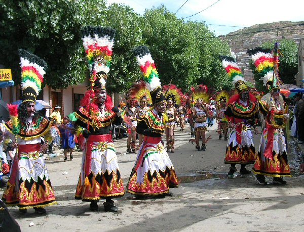
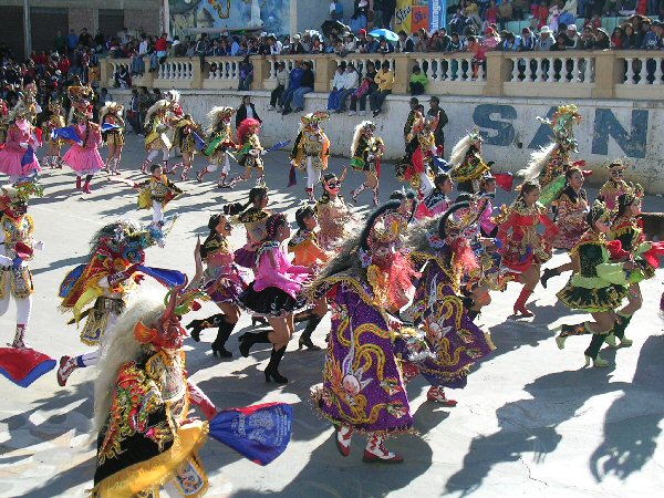
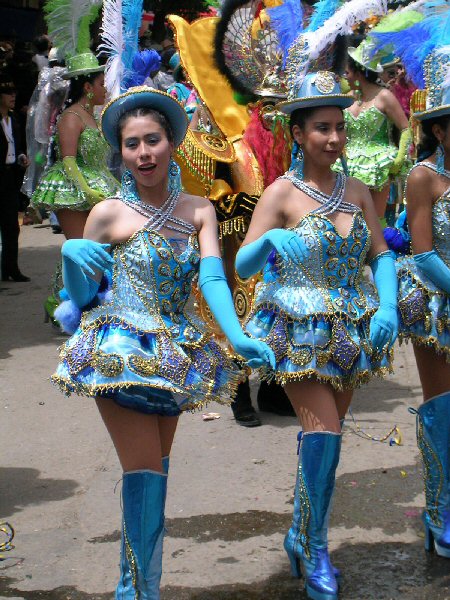
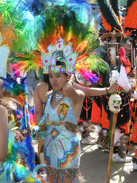
Oruro once a thriving mining centre is now famous for its Carnival which takes place around February each year and
lasts for two to three days with non-stop parade of exotic dancers in traditional folklore costumes.
Oruro is also worth a visit for its street market which fills the centre of the city on Wednesdays and Saturdays
and the regular markets which are permanently housed a short walk from the main square or the bus terminal.
Buses arrive regularly from La Paz and are inexpensive for the three and a half hour journey. Hotels are plentiful in the city
and particularly recommended for a friendly welcome is the Max Plaza hotel on the Plaza Principal and the new five star hotel Eden
under construction on the opposite side of the square.
A tarmac highway extends south of Oruro as far as Challapata and is being extended from there to carry tourists to
the edge of the Salar de Uyuni near Volcan Tunupa.
It is also planned to extend the highway around the beautiful Lake Poopo which will also make access easier for
visitors to Pampa Aullagas "capital of the lost Atlantis" and for those wishing to explore this remote and fascinating region.
History
The city of Oruro was founded on November 1st, 1606 by Don Manuel Castro de Padilla. (on the site of the previous ancient city of the Urus)
The city was formally born as Real Villa de Don Felipe de Austria,
in honor of then Spanish monarch Felipe III. Oruro owes its existence
to the discovery in the early 1605 of rich silver-concentrated minerals
in the Urus region, where the city derives its name from. During the 17th century, Oruro became the largest city in the Alto Peru region.
However, exhaustive mining activities exclusively on silver extraction prompted Indian workers to moved on to more lucrative prospects. Oruro became then an abandoned city. Oruro revived as a mining town by the late 19th and early 20th centuries, this time with the production of tin. In 1887, Simon I. Patiño, later one of the wealthiest men in the world, bought La Salvadora, a tin mine located east of the city of Oruro. Later on, La Salvadora became the world's most productive tin mine. Currently, Oruro in not the prosperous city it use to be long time ago and certainly is not one of the fastest growing cities in the country. By November 1996, according to data from the Instituto Nacional de Estadística (INE), Oruro's population was composed by 199,260 inhabitants.
Oruro department was created on September 5, 1826 during the government of Marshal Antonio Jose de Sucre,
and is situated in the western region of the Republic of Bolivia. It is bordered on the north by the department of
La Paz, the South by the department of Potosi, on the east by the departments of Potosí and Cochabamba,
and West by the Republic of Chile.
Oruro's history goes back to the Urus, one of the oldest cultures of the continent,
also in this department lived the Aymaras, Carangas, Quillacas and Soras.
It has traces of early human settlements dating back 10,000 years before Christ.
and has a stunning landscape of plains surrounded by volcanic islands and mineral waters.
It extends north to the town of Paria, and Callapa Patacamaya, to
the south to the salt flats and Ascotán Chiguana, east to Challapata Uyuni and
west near Sajama and the salt flats of Coipasa.
In Paria there is also talk of a major metropolis "uru" older than the Tiahuanaco culture,
Aymara and Quechua. When the Spanish first arrived here, they were attracted by the mineral wealth of the area.
When the Spanish conquistadors became aware of this enormous mining potential,
they called it the "silver table" and founded there on 1 November 1606 the present
city of Oruro in the name of Real Villa de San Felipe de Austria, in honor of the reigning monarch Felipe III .
The founding of the Villa Real de San Felipe de Austria covered
almost a square kilometer of area and the central area was the Plaza
Mayor (now plaza "February 10"). It then had 10 churches and private streets had
names like "The E Street", "Tambo Street in Jerusalem", "Street of the Blacksmith", "Street of flour" and others.
In the height of Conchupata was the limit of the Spanish Village,
creating what is today between Caro Street, Presidente Montes and La Plata.
That place was called "Boca de la Ranchería". There was a Tambo (ancient inn)
and further north the first native houses were erected.
Two streets were created here: one was the famous street from the village
(now President Montes) where lived the traders, bakers, tailors, carpenters,
officers, goldsmiths and others, many of whom also owned mines in the surrounding hills.
The other was the New Street (now La Plata), whose reference point
was the Church and Convent of the Company (now Cathedral).
During colonial times, the new political and institutional structure
was imposed on the basis of the significant wealth and gave
progress and advancement, but it negatively influenced the development of indigenous cultures.
The natural landscape was severely affected by the high demand for timber by
the mining sector activity and exhausted the original vegetation. Today
only small and degraded forests in small and inaccessible places remain. This phenomenon
directly impacted on the fauna of the region which thus deprived of its natural habitat was drastically reduced.
Climate
The city of Oruro lies north of the salty lakes Uru-Uru and Poopó and it is just three hours (by bus) south from La Paz. Located at an altitude of 3709 metres above sea level, Oruro its well known for its cold weather. Warmer temperatures generally take place during August, September and October, after the worst of the winter chills and before the summer rains. From May to early July, night time temperatures combined with cool wind can bring the temperature down to about -40 C. Summers are warmer, but despite the fact of being an arid area, there's quite a lot of rainfall between November and March.
Attractions to visit in Oruro:
Obrajes thermal baths
Very famous thermal baths located 25 kilometers from Oruro. An ideal place for relaxing and therapeutic bathing.
Capachos thermal baths
These hot springs are located 10 kilometers from the city of Oruro.
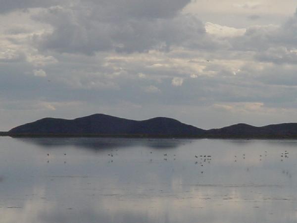
Lake Poopo (Lago Poopo)
Poopo Lake is one of the main lakes in Bolivia. It is located 55 km from Oruro. On the lake you will find the Panza island, ideal for fishing or spending a day outdoors. Near Lake Poopó live peasant and indigenous families with ancestral customs. The most popular villages are Poopo, Pazña and Aullagas. The area is considered an ecological reserve for its diversity of fauna, including many species of birds (such as flamingos).
Uru Uru Lake
Salar de Coipasa.
After Uyuni, Coipasa Salar is the second largest in Bolivia. It is located 225 km. from Oruro and it has an area of 2,218 km2. The salar's landscape is impressive. In the salar you will find communities living from salt mining and some lagoons.
Yarvicoya Church
The Church of Yarvicoya is a few kilometers from Oruro, within the jurisdiction of Caracollo, near the road to La Paz. The temple, declared a national monument, has a mestizo-baroque style.
Calacala
Calacala is an archaeological site located 21 kilometers from Oruro. Among the mountains and watersheds you will find an important collection of cave paintings.
How to get to Oruro
Several bus companies connect Oruro to the main cities of Bolivia. Travel time to:
La Paz: 3-4 hours; Potosi: 5 hours; Cochabamba: 4-5 hours; Sucre: 8-10 hours; Santa Cruz de la Sierra: 18-20 hours. There are also buses to Chile.
Oruro Museums
Culture House Museum
Address: Calle Soria Galvarro esquina Ayacucho
Descripción: Exposición de objetos históricos. Fue fundado en 1975 y depende de la Alcaldía de Oruro.
Sacred Art Museum San Miguel
Address: Calle Soria Galvarro y 1º De Noviembre S/N
Hours: Monday to Friday 8:00 - 12:00 y de 14:00 - 18:00
Description: It exhibits paintings, altarpieces, sculptures, liturgical ornaments and other pieces.
Mineralogical and Geological Museum
Address: Ciudadela Universitaria (zona sur)
Phone: (591-2) 5261250
Hours: Monday to Sutarday 8:00 - 12:00 y de 14:00 - 19:00
Description: This museum lies an exhibition of more than 2,000 mineral samples from the Andean region, central and eastern Bolivia.
Mining Museum
Address: Santuario del Socavón
Phone: (591-2) 5250616
Hours: Monday to Sunday 9:00 -12:00 y de 15:00 - 18:00
Description: The Mining Museum is a repository dedicated to the issue of mining and traditions of workers.
Eduardo López Rivas National Anthropological Museum
Address: Av. España S/N, Parque Zoológico
Phone: (591-2) 5274020
Hours: Monday to Sunday 8:00 - 12:00 y de 14:00 - 18:00
Description: This is a space dedicated to the exhibition of archaeological pieces of pre-Columbian cultures of Oruro.
Simón I. Patiño Museum
Address: Calle Soria Galvarro y Ayacucho S/N
Phone: (591-2) 5254015
Hours: Monday to Friday 8:00 - 12:00 y de 14:00 - 18:00
Description: Historic house.
Oruro
The Oruro region is ideal for photo safaris with its beautiful landscapes and historic setting.
Oruro – Gateway to Atlantis Extracted from "Oruro Inmortal"; Volume two Original text by Ramiro
Condarco Morales Location, boundaries and extent. The department of Oruro occupies a central-western location situated between
17 and 20 degrees south latitude, and between 66 and 70 degrees of west
longitude. It is limited to the north by the department of La Paz, to the northeast by
the department of Cochabamba, to the east and south by that of Potosi, and to
the west by Chile. The territorial area of Oruro occupies approximately 20,000
square miles. Sajama, in western Oruro territory, is the highest mountain in Bolivia
(21,463ft), seventh in the world , and third in America, after Aconcagua and
Tupungato ( 22,831ft and 22,309ft above sea level,
respectively). The Countryside The Western Mountains The western mountains of Oruro are not a mountain chain like the great chain
of the east, but rather a high plain suspended between 1300ft and 2600ft above
the level of the "Altiplano" immediately to the east, and more than 16,400ft
above the western coast to which it descends abruptly forming a type of
escarpment. There stand the guardians of Sajama, to the west, the Payachatas (twins):
Pomarapi and Parinacota 20,472ft and 20,767ft respectively, the latter higher
than Chimborazo (20,702ft) and MacKinley (20,669ft); further south rises
Alcoranco with 19,849ft, and further south still, three extinct volcanoes, Tata
Sabaya with 17,667ft, Iruputuncu with 16,929ft and Tunupa further towards the
east with 17,457ft above sea level The Great Mountain Chain of Oruro. The eastern mountains are no more than an extension of the two chains which,
on separating from the chain of Quimsa Cruz, detaches itself, south of Santa
Cruz, from that which faces east, towards Cochabamba, and converts itself into
the marginal chain of the high Oruro plateau, known by the name of the
Cordilleria de los Frailes. Hydrogrophy Lakes, rivers and salars In the southeastern region of the aforementioned plain, extends from north to
south and at an altitude between 11,942ft (Raimondi) and 12,119ft (Neveu
Lemaire) above sea level, an elevation obviously less than Lake Titicaca
(12,506ft: Neveu Lemaire, and 12,583ft: Raimondi) the now diminished Lake Poopó,
normally known also by the names of Lake of Panza or Pampa Aullaga, at least
until the first half of the present century. With traditionally renowned islands like the island of Panza and Filomena, is
found (or used to be found) a grand vegetative marsh, part of the traditional
habitat of the Uru-Muratos, like a grand entry into the abundant waters of
legend, tradition and history, which extended to around 1042 square miles
according to José Domingo Cortés and 1081 square miles according to Eliseo
Reclus. Lake Poopó’s waters are of little depth and cover a virtually flat bottom.
The depth varies between 2 inches on its wide banks and 9.6ft at its deepest
point; so much has changed since the beginning of the century when it was
studied by the French expedition of Créqui Montfort. Its degree of salinity is
twenty times greater than Lake Titicaca. In the southwestern sector of Oruro territory is to be found another lake,
equally or even .more salty than the preceeding one, Lake Coipasa. These lakes are, at present the two greatest remains of the ancient Lake
Minchin, and if they carry waters more salty than Lake Titicaca, they are
however richer in flora and fauna. Amongst the rivers of greatest importance, next to those already mentioned,
is to be found, from west to east, those of the basin of Coipasa, Sajama,
Todos-Santos, Lauca, Cosapa, Turco, Barras, Laka or Lakajahuira coming from
Pampa Aullagas; those of the basin of Poopó, Caqeusa, Corque,
Luchuy-Jahuira, and the principal river of all the Oruro hydrography,
Aullagas or Desaguadero, and others less significant draining
towards the southeast, like Sevaruyu and Márquez. A third lake, although transitory, is the UruUru, to the south of the
city of Oruro, which has to the west, a right lateral confluent, the Desaguadero
and a stream of importance, the River of Paria. These three systems are basins, that is to say closed or inward draining,
since they do not carry their waters outside of the territory, towards the seas
and oceans. Therefore, in long periods of scanty rain, first of all there are
droughts, then, afterwards lakes and lagoons dry up forming large salars or salt
pans, and there you find the salars of Coipasa and Garci Mendoza, as far as the
southwestern part of Oruro territory. Periferal zones of settlement and dispersal The territory of the department of Oruro shows yet a fourth gravitation
orientated primarily towards its ancient prehistoric littoral governed by the
proto-Uru population, particularly towards Arica, which is found in a latitude
very similar to Oruro. Both cities are located around 18 degrees of meridional
latitude. Arica was the main port to which the Uru population was tied in remote times;
continuing in the Hispanic-colonial period with the Hispanic-Criolla population
of Oruro; and in republican days until our own times, serving the Oruro
population of the past century and the present. But we mustn’t forget that, on
this route towards the west, the Antofagasta-Oruro railway must now submit
itself. Another orientation is towards the regions of La Plata. We mustn’t forget
that the the origins of the Pilcomayo are found around Culta, in southeastern
Oruro territory, and the Argentine-Bolivia railway runs also across the wide
eastern sector of the department from Challapata as far as the city capital
proper. A third orientation of importance is that of all the southwestern sector of
the Department of Cochabamba, a territory tied to Oruro, because the mountainous
branch of Los Frailes is nothing more than the twin of that which opens out from
the mountains of Santa Vera Cruz, to the south of Quinsa Cruz (the Pass of Tres
Cruces) heading, in a east-southeast direction, towards Tunari (Cochabamba). The Oruro-Cochabamba railway and the Oruro-Ayopaya road, give access to this
orientation in the direction east-northeast as far as the Oruro capital. Finally, the fourth axis of gravitation is that of the north-east, along the
Caracolla -El Alto road, heading towards La Paz first of all, and south-Peruvian
territory, then, by the railway La Paz – Guaqui. The importance of all that already mentioned in respect of the location, area
and frontiers in relation to zones of settlement and dispersal, is that the
relief geography of the department of Oruro renders easy access to its paths,
trails and roads. Thus the geographers of the French school of Paul Vidal de la Blanche, have
said that the Altiplano is a "continental link" and a "stage", without which the
two most important vice-royalties of America (Lima – Buenos Aires), would not
have been able to communicate as rapidly as they did since the beginnings of the
Hispanic-colonial period. Climate The climate of the territory comprising the department of Oruro, has been
considered as corresponding to the sub type climatological Dw, which signifies a
microthermal climate of dry winter, or low temperature and lacking in rainfall
and atmospheric humidity in winter. In such an extensive territory no range of contrasts predominate, according
to the climatologists of the school of Koeppen, at least two climates: the EH,
or climate of high snow produced by the currents of cold generated by the high
snowy peaks of the western mountains, on one side, and the BS, belonging to the
salty steps. Also there exist microclimates, or climates of local extension,
prevailing in high valleys or ravines of the eastern chain. Such is the case of
Urmiri. In Sajama there are places where, at 13,779ft above sea level, the
temperature does not fall below15° centigrade below
zero, but more to the south in Lipez (Potosi) there are lower zones in which the
temperature falls to 30° centigrade below
zero. The Soil The soil is the product of the relief, climate, surrounding life and the
generating rocks. In that which belongs to the first three, (climate, relief and life) we would
think that the dryness of the soil makes a workable soil in Oruro non-existent,
but that’s not so. Only in the extremely high regions, of very low temperature,
of very dry climate and scarce animal and vegetable life, as in the zones of the
Salar de Uyuni, the cold and the drought impede the humus, the workable mantle
or layer The rare and less dense air favours evaporation and consequently drought.
These soils belong to the high mountains or the wild moors. But in the less high
areas, which vary between 12,467ft and 11,811ft where the cold is less dry and
the evaporation less, with the advantage of even a little rainfall, the ground
there carries an adequate covering of fertile soil. On the banks of the three great lakes and the great number of lagoons of the
old Oruro provinces of Paria and Carangas, is found the presence of a great
quantity of silicates by the side of volatile materials and small amounts of
nitrogen and phosphoric acid. But there the spring and summer rains bring along
with their precipitation great amounts of vital elements, compensating, for a
while the natural defic- iencies in such a manner that the soil is only in
autumn and winter deficient of everything, and repeatedly, in spring and summer,
very fertile and productive. The supposed dryness of the Oruro Altiplano is not a myth, and the main cause
of its condition has been man destroying the vegetative cover. And more so in
the republican period than in the Hispanic-colonial; the chronicler P.Ramirez
del Aguila, points out that Oruro exported in the XVIIth century to Peru and
Spain "the best cheeses in the world", a fact which reveals the natural aptitude
of the soil for this task. The soils of Oruro are then suitable as much for agriculture as for cattle
rearing and its derived industries, even in the grounds near the salars of
Salinas de Garcia Mendoza or the Salar de Coipasa. Plants flourish there called
halófilas, or those adapted to this zone, like varieties of quinoa.
Plant, animal and mineral riches The potential of the Oruro soil for agriculture, arboriculture or fruit and
flower growing, just like cattle rearing, awaits only the enterprising hand of
man. Flora In contrast to that which one might vulgarly believe, the flora of Oruro is
considerably rich. This is demonstrated by the agreement existing between the flora of the
distinct regional locations; the mountains, the saltflats, the lakes and the
pampas. But in the description of each one of the species we must consider the
habitat in which it normally flourishes.In their distinctive habitats we find
grasses, herbs, shrubs and trees. We can mention a few of the most
characteristic beginning with that which the current language calls
agárico, technically "Boletus igniarus", renowned for its
combustibility and popularly called in the native language, Kallampa or
Kanchayuyu. In reality, we are dealing with edible mushrooms used in
other times as tinder or inflammable material to obtain primitive fire. In marshes and lakes, watercress thrives: the Nasturtium officinale of
the old botanists is the uqururu or willkuyuyu of our own people,
a plant of stalks and leaves edible in salads. The famous kantuta, our national flower, is the Peryphragnus
dependens of the botanists, the kantut or kantui of our native
language, and the herb which brightens our gardens and has a thin stick-like
woody stalk. The "cortadera" of the present Castillian language (Typa
angustifolia), is the siwinqa or the sij-sij of our original,
whose stalks are used in basketwork. The siwinjka thrives in the mountain
gorges, or in the high banks of the mountain streams. The rushes of the Spanish
are represented here by the Scirpus riparius of some botanists, it is our
own totora, the t’utura or the mat’ara in the original tongues. It
is a plant of edible rhizomes and stalks used in basketwork and the construction
of boats. Straw abounds in the steppes or uncultivated lands for which the
scientific name is Stipa ichu or straw of the steppes, it is the
ichu, the jichu, the iru or the ch’apiujsa of our
original tongue. There are various firewoods. Amongst them the tola of the local
language is notable, of which there are several varieties according to their
subspecies, also the t’ula in the original tongue. We mustn’t forget the
yareta known and differentiated by the botanists as Azorella biloba,
Azorella diapensoides or Axorella glabra. It is the yarit’a or
the timillu in our original. It is a plant which thrives at ground level
and good for covered domes. There are numerous Mantur or airampu which is the
orchilla of the Spanish, with bittersweet fruit , and the qiwayllu, a cactus which grows at
considerable heights. Finally, and the most important, the pair of trees represented by the two
Spanish olivillos, the kiswara (Polylepis e incana) and the
q’eñua (Budleya incana or longifolia); two trees of wood and with
burnable trunks. They are found in ravines or plains at the foot of mountains
forming groves and small woods, like those of the ancient region of
Sajama. There is a considerable amount of original fauna, some endangered. Amongst the mammals are found species such as the alpaca (Auchenia
pacos and Lama pacos), the guanaco (Auchenia-guanaco and Lama guanaco),
the llama (Auchenia lama or lama glama) and the vicuña (Auchenia
vicunha or Vicugna vicugna). The guanaco has disappeared after a process of extinction due to unknown
causes. Perhaps it was a victim of intensive hunting. The vicuña is also in the throes of extinction; the llama is no longer used
as a beast of burden, cared for and pampered, like sheep, according to a
description by the chroniclers of the XVIth century. Amongst the rodents of socio-economic importance, are found the
achulla (Dipodomys nelsoni), the chinchilla (Eyromis lanigera),
the vizcacha (Lagidium cuscus) and the wanku ( Cavia aparea) or
cui de la pampa (pampa wanku). We must add to these mammals the armadillo
or quirquincho, an animal almost symbolic of Oruro, which sadly is also
becoming extinct. Amongst the birds, there are web footed and long legged species. Amongst the
first are found wild ducks (serdionis carunculata) , the pariwuana
(Phoenicopterus andinus), and the wallata, (Bernicia melanoptera).
Amongst the second group are found the p’isaka (Notoproeta Pentlandi).
There is also a transitory bird which is the suri, an ostrich technically
known as Rhea macrorhyncha, a variety of the American Rhea. Around the middle of the century it was very usual to see eggs of the
suri for sale in the markets of Oruro, but today, sadly, this beautiful
bird is also on the road to extinction, or perhaps, has already disappeared. Amongst the fish of the lakes and rivers, it is the same. The ispi
(Crestias Agassizi) is, at present, the object of a commerce completely
unconcerned with the survival of the species. The so-called bream: the
qisintu (Orestias Pentlandi) and the umantu (Orestias Tschudi)
have vanished, just like the mawri (Trichomycterus rivoulatus) and the
such’I (Trichomycterus dispar). Minerals The ancient natural processes forming the Earth’s crust (movement,
sedimentation, stratification, emergence, rainfall, evaporation etc) leave in
the depths of the subsoil and on the surface all sorts of formations, seams,
veins, pockets, deposits of differing natural minerals of varying value,
important as much for the human geography as for their commercial value. To begin with, we must take note of the deposits of the Salar de Coipasa
which, at different times of the year gives rise to an intense traffic in
precious salt coming from the pocket south of Oruro, a commerce orientated to
the area surrounding the city capital and towards the markets of the high
valleys and valleys of Cochabamba and La Paz. Original inhabitants of the aforementioned salar, popularly known by the
vernacular designation of "llameros" (llama-men), are in the habit of
transporting on the backs of the pack-animals, this product along with others
from these lands, such as potatoes, chuño and charki or chalona. But the mining riches of Oruro stem from and still rest in, the abundance of
different natural minerals , chiefly silver and tin. Silver in its natural form was very common, said Federico Ahlfeld, in the
area surrounding Oruro, Carangas, Potosí, Porco and other locations and deposits
of the south and centre of Bolivian territory, but now it is only found in
minuscule crystals, or in the showpieces preserved in collections and
museums. Silver is also found in Oruro in the form of sulphuric minerals such as the
common cochizo or so-called silver-grey copper, tetraedrita, which was,
according to the Hispano-colonial documents, the predominating mineral of silver
as much in Oruro as in Potosí. There were minerals with yields of 8, 10 and 12% of silver in Potosí, and of
14% in Oruro according to references by the mineralogist J.Domeyko (1879) for
oruro and Colquechaca (Potosi). Another silver sulphide was the renowned rosicler of silver which was
very common in Carangas (Oruro), as much as in Colquechaca and Porco
(Potosí). Another silver sulphide is andorita, found in Itos and very common in
other mines of Oruro, contrary to its scarcity in the mines of Potosí. Amongst the mineral of tin found in oruro, we must mention casiterite,
an oxide of tin present in former times in the hill of Pozokoni de Huanuni, one
of the old mineral production centres of the Patiño firm. As to gold there are important deposits in Oruro, those of Iroco, La Joya and
Corihuiri in Poopó. The first, near to the city capital, with veins of quartz
which gives its name to the type; the second, of deposits of pirita
aurifera, which also gives its name to the corresponding type, and the
third, that of Poopó, which appears in the form of thin films of gold over
wolfram, a variety of wolfram with iron. Geography Political Administration Historical Geography


The church is built over the entrance to the mining museum
and named after the ancient tunnels, Socavon

The Plaza Principal or main square is one of the most delightful in Bolivia,
a place to rest and savour the atmosphere of the city.
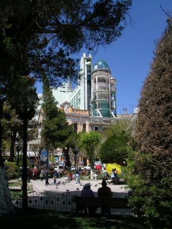
The newly built Eden Hotel overlooks the main square.
Time in Oruro


Uru Uru Lake is located south of rail town Machacamarca. At the lake you can fish and learn about coastal population customs. Machacamarca has a comprehensive railway museum.
You can also travel by train from Oruro to Uyuni and Villazon.

Routes around Oruro

Bolivian music on
youtube - diablada

more Bolivian music on
youtube - tinkus
 Luis Gutierrez, your personal guide to Oruro, and Atlantis Pampa
Aullagas
Luis Gutierrez, your personal guide to Oruro, and Atlantis Pampa
Aullagas

atlantisbolivia.org homepage

Volcan Tunupa in the centre of the rectangular Altiplano rises to a height of about 5200 metres (17060ft)
....
Volcan Tunupa is in the centre of the rectangular Altiplano surrounded today by salt salars
which turn to lakes in the wet season when they flood.
It can be likened to a Mount Atlas, holding up the sky and in the sense of the Nahuatl word "atl" meaning "water"
or "surrounded by water"....
Atlas "knew the sea in all its depths" and Tunupa was the god of rivers and waterways, a sort of equivalent
of Poseidon or the son of Poseidon - Atlas.....
Volcan Tunupa when the salar turns into a salty sea.

The central peak of Volcan Tunupa holds up the sky.
see also Tunupa Gallery for more photos of the salars and lakes around Oruro

Volcan Sajama in the north-west corner of the rectangular Altiplano rises to 21,448ft (6537 metres)
and is sometimes considered to be Pacha Mama or Mother Earth herself - Gaia in the language of the western world....
Nevado Sajama
see also The Atlantis Trail for more photos and recommended adventure route around Oruro
translated from the Spanish by J.M.Allen 
The most remote precedents are those of the local geohistory, and go back to the times when the first pockets of human population appeared here.
As far as we know up to now, the first inhabitants of our lands were the ancestors of the Urus, who extended first of all from the adjacent western coast, today belonging to Chile, and then , along all the inter-Andean corridor between Lake Titicaca (la Paz), in the north, and the village of Eskala (Sud Lipez, Potosi), in the south, crossing the mountain chain towards the east. Therefore, all the actual territory of Oruro constituted a crucially interposed centre, from west to east, between coast, mountains and eastern sub-Andean zone, and between the remote Altiplanos from north to south.
In this way, our remote ancestral homeland remained at the centre of a vast stage populated by nomadic hordes who moved along the course of the mountains. From that time, our actual State remained divided into two great lateral strips separated by the attractive forces of the sheltering rocks of both mountain chains. In those days were predestined the great divisions of the State, afterwards known as Carangas, in the west, and Paria, in the east, but which, in those times, were known by the names of Uracharqu and Warsicharqu. Or, to put it in another fashion, the road of the peaks, to the west, and that of the rivers and lakes to the east, or that of the hunting grounds and gathering of suri eggs, in the middle of lagoons, peaks and sandbanks to the west; and the fishing places and collection of molluscs, roots and totora stalks, in the great lakes and rivers of the eastern strip, from where flow the great volumes of water fed by the rains, rivers and mountain torrents from nearly half of all the State.
The proto-uru division of that which is today our State lasted for many centuries
retaining the denominations of Usu and Waruchaqu for the nearby north and the distant south, respectively
Here in Oruro, appeared meanwhile, flourishing prehistoric megalithic cultures from which were created the the villages of origin Uru or proto-Uru, already divided into distinct groups known as ethnic groups belonging to the first wave of population of long face and skull (dolichocephalic): Urus and Uru-Chipayas.
Much later, about the time of the decline of Tiwanaku, there appeared in our territory new populations of short face and skull, known today as Aymaras, bearers of the qulla or colla civilisation, constructing buildings with stone or mud with circular or quadrangular bases, which with time were called chullpas, chullperios, gentilares or casa-tumbas, (house tombs) of the Gentile peoples, those without knowledge of the Christian faith.
At that period our territory remained subdivided, from north to south as before, in the two same divisions: the western and the eastern, with the previous names given by the surviving Urus, and with those of Urqusuyo (peaks) and Umasuyo (waters) by the recently arrived proto-Aymaras.
The division lasted into Inca times, with a greater bipartite accentuation between Paria (east) of Parina (flamenco), on one side and for the other, Karanga (perhaps of "Kara" indicating "peaks and plains" says L.Bertonio).
After the Spanish Conquest, the two territorial divisions consolidated the denomination qulla or Colla, outlining subdivisions of the peoples recently arrived and mixed with their predecessors, such as the sora-uma of Paria in the north; the Charka and Karakara of the centre-west; the Killaka from around lake Poopó towards the parts centre-west, and the Qaranqa of the vast zone of Qarança or Carangas, to the west of the actual territory already described.
In the midst of all this, there existed minority groups of more or less pure ancestral origin such as the Uru-Chipayas, Uruquillas, Urumurus, Urumiris, Uru Urus, etc.
Without doubt the Hispanic colonisation accentuated the bipartition referred to between western Karanga (Chuqilla) and western Paria (Uru), then the chroniclers praised the rich province of Paria.
Pedro Cieza de León (1518 –1560) praised the "great province of Paria" as "something greatly appreciated by the ingas" (Inca) whose inhabitants must be more Uru than Aymara, because according to the chronicler they wore "tiny hats made of wool" , that is to say the chucos of Uru origin mentioned by Juan de Matienzo (1520 – 1579). Because of this Cieza as well as Matienzo each said independently that the "Collas" or Aymaras only reached as far as Caracollo. There can’t be any doubt that only the governing families of Oruro in Inca and Hispanic-colonial times were of qulla (Colla) or Aymara origin.
The Uru population was particularly based in Paria. We must take into account that this province extended from the zone south of Caracolla towards the southern extremity of the western part of our State, including the river Pampa Aullagas and Lake Poopó.
Finally, in republican times, Oruro was formed on the 23rd of January 1826, although dependant on La Plata (Charcas), with the two traditional divisions: Carangas and Paria.
The 5th of September 1826 Cercado was added. On the 16th of October 1903, Poopó was added with its capital of the same name. The same day and month, the province of Avaroa. On the 13th of October 1941, the province of Ladislao Cabrera. The 26th of November 1941, the province of Dalence. The 11th of November 1950, the province of Sabaya and the 26th of December 1959, the province of Atahuallpa.
Thus was dissolved the traditional contrast between the western Carangas and the eastern Paria, with the disappearance of this latter which extended on the east from the north to the south and having governed up to Hispanic-colonial times , the zones of Arque and Capinota (today Cochabamba), known as Jatun Paria.
Today Oruro accounts for six provinces of the old Paria: Barrón, Cercado, Dalence, Poopó, Sebastián Pagador and Avaroa, and nine of the old Carangas, with North Carangas, Saucari, South Carangas, Ladislao Cabrera, Totora, Sajama, Litoral, Mejillones and Atahuallpa. An archaic division and subdivision imposed by tiny zonal interests which break up the two great geotectonic divisions of the State.
Important pre-Columbian cultures are found in Oruro, converting it into the oldest centre in Bolivia where the remote ancestors of the Urus, Chipayas and Siriono lived..
Thus "Origin of a Millennium City" recognises that Oruro has a prehistoric antiquity two centuries older than the appearance of Tiwanaku.
The footprints of ancestral cultures may be seen in the Department. Their forces have transcended the centuries of Colonialism and the Republic and are part of the Oruro surroundings today.
To enter into this enigmatic world presents us with a series of questions about our millennium origins.
THE customary and dominant focal point in respect of the foundation of Oruro is to identify it by the calendar date of its appearance as an Hispanic city. But it has not been usual , for it is little told to the few investigators, nor suspected as a consequence, to know the millennium prehistory, just like the ups and downs of its curious destiny.
Just the same, when one talks of the foundation of the city of Oruro, we can’t miss out the five great cycles of its repeated moments of birth, appearance, peak, servitude, reappearance, splendour , new horizons, and revitalisation across time. These cycles were:
The archaic cycle of the first prehistoric settlements up to the appearance of the preclassic civilisation.
The prehistoric cycle of the sacred city.
The prehistory cycle of the Inca domination.
The almost legendary cycle of the Holding of Paria and of Lorenzo de Aldana.
The cycle of the Seat of San Miguel of Oruro, and the cycle of the town of San Felipe de Austria.
That is to say, that when we talk of the founding of Oruro in 1606, we are talking properly of a re-foundation, because that was in reality, the Hispanic founding of the town.
From this point of view, the city of Oruro is historically and socio-geographically a city capital unique in Bolivia, and, in contrast to its seven secular sisters of antiquity, Oruro is the only one of indisputable millennium antiquity, and perhaps twice times millennium antiquity.
The Prehistoric City
The science of man accepts, and no-one who was not insensitive would deny – thatthe first inhabitants of our territory were remote ancestors of the Urus, Chipayas and Sirionos, whose remaining bones are easily identifiable by the dolichocephalic (long head) skull and other particular anthropological features, which distinguish them from the later braquiodes (short head) : Aymaras and Quichuas.
Some anthropologists such as José Imbelloni, Salvador Canals Frau and others, deny that these first inhabitants had developed forms of culture superior to the Mesolithic. However, naturalists and other scholars, have not thrown out the possibility of recognising them as bearers of a high culture.
Rudolph Huathal, in 1908, assigned to the "tribe of the Urus" the "mask" of stone found by Ernest Hagemann, at a depth of 13ft, in the city of Oruro.
A.Posnasky, for his part, has collected traditions according to which the Uru people lived out six periods of varied fortune: that of their arrival at the inhabited territory, the flood or of prosperity as navigators, the Colla invasion, the drought, the destruction of Tiwanaku, and the retreat of the Urus to their locations of origin.
Besides, Posnasky intuitively held that "the true centre of the Urus was the present region of Oruro".
The Oruro archaeology, for its part, after Posnasky has succeeded in localising in each "region of Oruro"… many historic-cultural centres assignable to the pre-classic cultures of the mounds, such as Suqutiña, Qutaña, Wilahaqi, Quriwiri, etc., centres which C.Ponce S., assigned to his so called culture of Wankarani.
Finally, Dick Edgar Ibarra Grasso, without excluding the Urus from his condition of high culture, by his approximation to the historic-cultural school of José Imbelloni, came to hold that "Oruro is the oldest city in Bolivia", with "a culture much older than that of Tiahuanaco", with inhabitants who constituted " the first agricultural people amongst those of America.", although a little more recent than the Urus themselves. In fact there is no surviving ethnic testimony to this hypothetical agricultural people which would not be the Uru-Chipaya in their subsequent state of decultural prostration.
The important thing is that that this hypothesis aggrees with the historic reality witnessed as much by the Uru tradition collected since Posnasky up to Rossana Barragán Romano, which is confirmed by the toponymy (place name) of oruro (Horuro or Jururu), and it is really positive to recognise that our city has a millennium antiquity before the urban period of Tiwanaku, whose age as an urban centre strictly speaking is of 1800 years, so that the prehistoric antiquity of Oruro goes back as far as, at least, two centuries before the appearance of Tiwanaku as a city, that is to say to an antiquity interposed between Nasca 1 and Nasca A.
In Bolivia there are only three centres which merit the name of prehistoric cities: Tiwanaku, Samaypata and Incallajta, but none of these is obviously a department capital such as Oruro.
We must not leave off from thinking, in effect, that a mountain range of silver, surrounded by the four cardinal points of faraway centres and nearby preclassic civilisation, would not have begun to constitute a classic prehistoric city.
Including in our suburbs places such as Qinturaya and Quichiraya, the sandflats of the east, the south, the northeast in which are found the remains of formative civilisation with clear signs of having practised duniculture; with the remains of ancient agricultural platforms in the northern skirts of Jampatuqullu (San Pedro) ; we figure ourselves in our youth, whose peak, shows an aspect of typical Uru stamp, and it is difficult to deny the idea according to which there has been in Oruro a prehistoric city before Tiwanaku.
There are many archaic testimonies found in Oruro which show by themselves, the presence of a great pre-historic city, because these have all the characteristics belonging to the high megalithic cultures.
There are no great megalithic structures surviving, properly speaking, because they disappeared due to the great mining works of the XVIth century, something which didn’t happen at Tiwanaku. A decisive argument for this thesis is, besides, that in our departmental territory there is an ethnic group of macro-Maya language: the Chipayas, and as a fact we must record that, according to S.Linné, the Mayas were the "Greeks of the new world", the civilisers of pre-Hispanic America; and in Oruro was found, the diffusion centre for ethnic, culture and civilising languages.
The Cycle of Inca Domination
The previous paragraph shows, in a certain fashion, the exceptional esteem which the Incas had, according to Pedro Cieza de León, for the province of Paria to which Oruro belonged, a fact which is explicable also by its population trained since antiquity in the perfection of metallurgy in gold and silver.
The legendary cycle of Paria and of Lorenzo de Aldana
After the Spanish conquest we can tell of three important facts: First: The foundation of Old Paria by Juan de Saavedra, in 1535. Second: The granting of the Holding of Paria to Pedro del Barco in 1536. Third: The arrival of Lic. De la Gasca in Peru, a governor who came with the civil war of 1548, and confirmed in the same year the granting of the Holding of Paria to Lorenzo de Aldana (1548).
This last act radically changed the history of Paria, of Oruro and of the native population, that is to say the Uru population until then under the Aymara and Quichu domination.
Events happened in a cryptic fashion: Lorenzo de Aldana appeared exceptionally enriched overnight, with the contradictory antecedent that the Holding of Paria had only allowed Pedro Del Barco a rent much inferior to others of New Toledo, precursor of the Audiencie de Charcas, today Bolivia.
However, such a foundation had no other effect than to officialise the existence and growth of the old city adjusting it to the norms of the legislation of the Spanish Empire, a fact which most of us know in a more or less detailed manner, but always without suspecting that such a city raised itself up on the debris of an old prehistoric city, the City of the Urus, for the misfortune of those and the delight and happiness of the newcomers: Quichuas, Aymaras, Spanish and others.
"Oruro Inmortal", in two volumes, contains many outstanding colour photographs and is published by ECCO Publicidad Integral, La Paz, Bolivia